7 Best GPS Calibration Methods
Your GPS accuracy directly impacts everything from navigation to location-based apps, yet most people don’t realize how much community-driven methods can improve their device’s precision. Traditional GPS calibration often falls short in urban environments, dense forests, and areas with poor satellite coverage, leaving users frustrated with inaccurate positioning.
Community-based calibration techniques leverage crowdsourced data, local knowledge, and collaborative mapping to enhance GPS performance where conventional methods struggle. These innovative approaches help you achieve better location accuracy by tapping into the collective expertise of users who’ve already mapped and tested specific areas.
Disclosure: As an Amazon Associate, this site earns from qualifying purchases. Thank you!
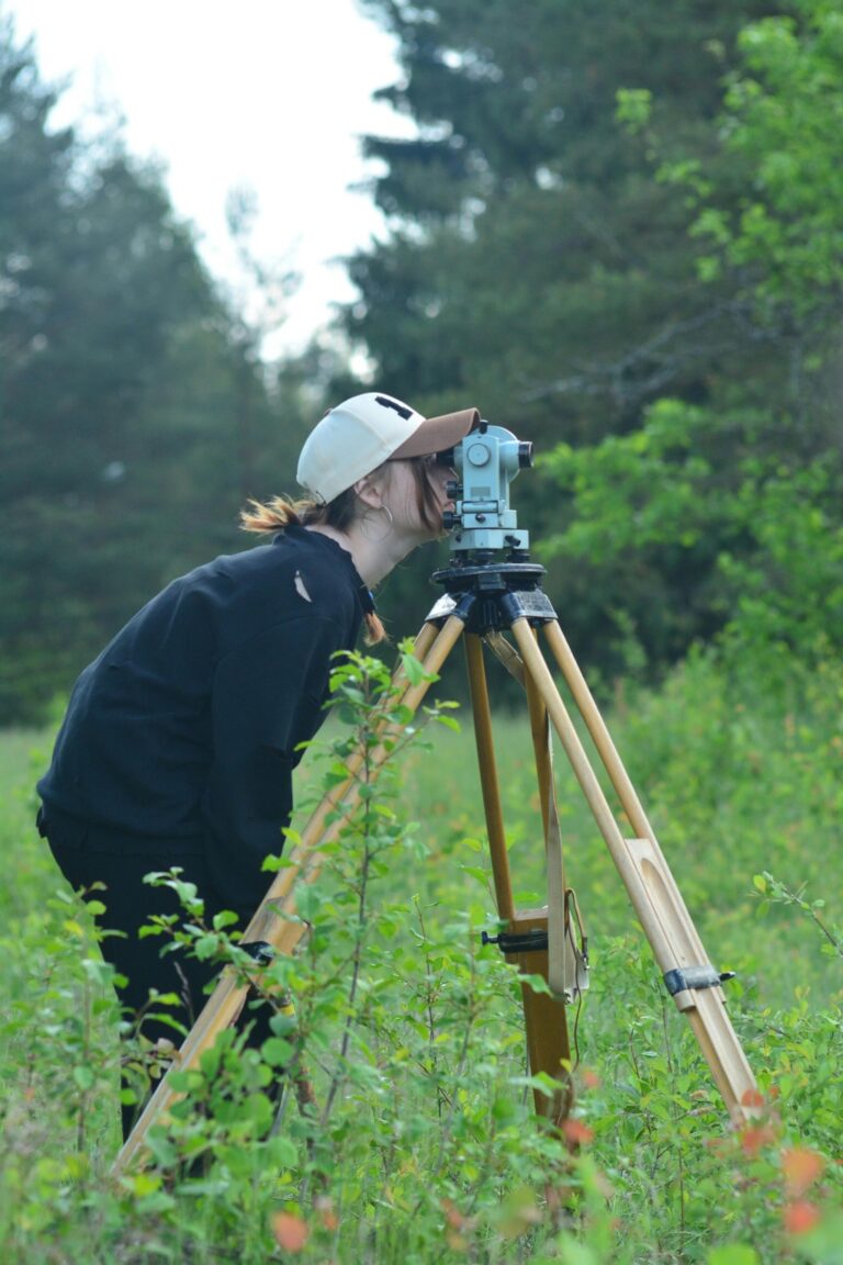
Ground Control Point Surveying Through Crowdsourced Data Collection
Building on community-driven GPS calibration methods, ground control point surveying harnesses the collective power of local volunteers to create precise reference networks. This approach transforms traditional surveying by distributing data collection across multiple community participants.
P.S. check out Udemy’s GIS, Mapping & Remote Sensing courses on sale here…
Establishing Reference Points Using Community Volunteers
Recruit trained volunteers to establish precise ground control points using handheld GPS units and smartphone applications like Survey123 or KoBoToolbox. Train participants to identify permanent landscape features such as manhole covers, survey monuments, or building corners that serve as reliable reference markers. Coordinate data collection sessions where volunteers simultaneously record GPS coordinates at predetermined locations, creating multiple measurements for statistical validation. Provide standardized data collection protocols including required metadata such as timestamp, weather conditions, and equipment specifications to ensure consistency across all volunteer contributions.
Stay connected anywhere with this compact satellite communicator. Enjoy two-way messaging, interactive SOS, and TracBack routing for confident navigation. Battery lasts up to 14 days in tracking mode.

Coordinating Local Survey Teams for Accuracy Verification
Organize verification teams using experienced community members who cross-check initial GPS measurements through independent data collection sessions. Deploy teams to resurvey critical control points using differential GPS methods or Real-Time Kinematic (RTK) positioning when available through local surveying equipment. Schedule systematic verification rounds where different volunteer groups measure identical reference points to identify measurement discrepancies and eliminate systematic errors. Establish quality control protocols requiring minimum three-person teams per verification session, with results uploaded to shared platforms like QGIS Cloud or ArcGIS Online for immediate accuracy assessment.
Open Source Software Development for GPS Correction Algorithms
Open source GPS correction algorithms empower communities to develop tailored solutions for specific geographic challenges. You’ll contribute to software libraries that address local positioning errors while building collaborative testing frameworks for enhanced accuracy.
Contributing to GNSS Processing Libraries
Contributing to established GNSS libraries like RTKLIB and pyGNSS accelerates algorithm refinement through community expertise. You’ll submit code patches that address specific positioning challenges in your region, such as multipath interference corrections or atmospheric delay models. Developing specialized modules for unique terrain types enables other users to benefit from your local calibration insights. Participating in library documentation helps newcomers understand implementation requirements and testing procedures.
Collaborative Code Review and Testing Protocols
Implementing peer review systems ensures GPS correction algorithms meet accuracy standards before community deployment. You’ll establish testing protocols that validate algorithm performance across different hardware configurations and environmental conditions. Creating standardized benchmarking datasets allows multiple contributors to evaluate correction effectiveness consistently. Organizing virtual testing sessions enables real-time collaboration between developers and field testers for immediate feedback integration.
Citizen Science Networks for Real-Time GPS Error Reporting
Citizen science networks transform GPS users into active error detection agents, creating comprehensive databases of location accuracy issues. These networks leverage smartphone sensors and community participation to identify systematic positioning errors across diverse geographic environments.
Experience vivid content on the Galaxy A16 5G's 6.7" display and capture stunning photos with its triple-lens camera. Enjoy peace of mind with a durable design, six years of updates, and Super Fast Charging.

Mobile App-Based Error Detection Systems
Automated detection apps like GPS Status & Toolbox and SatStat continuously monitor signal quality, satellite geometry, and positioning accuracy while you navigate. These applications flag anomalies in real-time, recording HDOP values, signal-to-noise ratios, and multipath interference indicators. Crowdsourced reporting platforms such as MapQuest’s GPS Logger and OpenStreetMap’s StreetComplete allow you to submit error reports with precise coordinates, timestamps, and environmental context. The apps automatically correlate your reported errors with similar incidents from other users, building comprehensive accuracy maps for specific locations and time periods.
Community Validation of GPS Anomalies
Peer verification systems enable multiple users to confirm GPS errors at identical locations, creating statistically significant datasets for accuracy assessment. You’ll participate in validation campaigns where community members visit flagged coordinates using different GPS devices and measurement techniques. Expert review processes involve experienced surveyors and GIS professionals who analyze crowdsourced error reports, verify spatial patterns, and classify anomalies by type and severity. These networks maintain quality standards through voting mechanisms, reputation systems, and cross-validation protocols that ensure only verified GPS errors contribute to calibration databases.
Amateur Radio Operator Networks for Differential GPS Support
The SMAJAYU SMA26 RTK GNSS provides precise geospatial data with 0.5cm accuracy and up to 10km range. Its IMU tilt compensation allows for efficient data capture on uneven terrain, while the long-lasting battery supports extended field use.

Amateur radio operators create robust DGPS networks that significantly enhance GPS accuracy through real-time correction broadcasting. These HAM radio networks provide critical infrastructure for precision positioning when commercial services aren’t available.
HAM Radio DGPS Beacon Establishment
HAM operators establish DGPS beacons using dedicated radio frequencies to broadcast real-time GPS corrections across regional coverage areas. You’ll find these beacons operating on designated amateur bands, typically transmitting RTCM correction messages that improve positioning accuracy to sub-meter levels. Licensed operators coordinate beacon placement to maximize geographic coverage while avoiding interference with existing services. The stations require reference receivers at surveyed locations to generate accurate correction data. Many operators integrate their beacons with existing repeater infrastructure to extend transmission range and reliability.
Emergency Communication Backup Systems
Get a clear view around your RV with the Furrion Vision S wireless backup system. It features three waterproof cameras with night vision and a 5-inch monitor for easy parking and enhanced security.

Emergency communication networks provide critical DGPS support when primary infrastructure fails during disasters or remote operations. You can access these backup systems through portable HAM radio equipment that receives correction signals from mobile or temporary beacon stations. Operators establish redundant transmission paths using multiple frequency bands and propagation modes to ensure continuous service availability. The systems often integrate with emergency services coordination centers to provide accurate positioning data for rescue operations. Battery-powered beacon stations can operate for extended periods during power outages, maintaining GPS accuracy when commercial correction services are unavailable.
University Research Partnerships with Local Communities
Academic institutions bridge GPS calibration research with community needs by combining rigorous scientific methods with local geographic knowledge. These partnerships create sustainable frameworks for improving location accuracy through collaborative field studies.
Student-Led GPS Calibration Projects
Student researchers develop calibration methodologies through thesis projects that address specific regional GPS challenges. Engineering and geography students establish campus-based reference stations to test correction algorithms in controlled environments. University teams coordinate with local government agencies to deploy temporary GPS monitoring networks during semester-long field studies. Students validate their calibration techniques by comparing results against professional surveying equipment in partnerships with municipal engineering departments.
Get accurate leveling with the KEZERS 32X Optical Level Kit. It features 32X magnification, a self-leveling system, and comes with a tripod and grade rod for easy setup.

Academic-Community Data Sharing Initiatives
Universities establish open-access GPS correction databases that serve both research purposes and community navigation needs. Academic researchers share processed DGPS correction data through institutional repositories accessible to local emergency services and transportation departments. Community partners contribute field observations and error reports to university-maintained GPS accuracy databases. Research institutions provide training workshops where community members learn to collect standardized GPS measurements for ongoing calibration research projects.
Regional GPS User Groups and Calibration Workshops
Regional GPS user communities create collaborative environments where calibration expertise spreads naturally through hands-on learning experiences. These local networks combine professional surveying knowledge with amateur GPS enthusiasm to develop region-specific accuracy improvements.
Monthly Meetups for Equipment Testing
Monthly equipment testing sessions bring together GPS users to evaluate device performance across local terrain challenges. You’ll find these gatherings typically rotate between urban canyon areas, dense forest locations, and open field environments to test positioning accuracy under various conditions. Participants compare handheld GPS units, smartphone applications, and professional surveying equipment while documenting signal strength variations and positioning errors. These sessions generate valuable calibration data specific to your region’s geographic characteristics and atmospheric conditions.
Knowledge Sharing Between Professional and Amateur Users
Professional surveyors and amateur GPS enthusiasts exchange calibration techniques through structured workshop presentations and informal mentoring relationships. You’ll discover that licensed surveyors often demonstrate differential correction methods while amateur users contribute innovative smartphone-based testing approaches and crowdsourced error detection strategies. These knowledge exchanges create hybrid calibration methodologies that combine professional accuracy standards with community accessibility. Workshop participants frequently develop regional GPS correction databases that benefit both professional surveying projects and recreational navigation applications.
Online Forums and Wiki-Based Knowledge Repositories
Online platforms create powerful hubs where GPS users document accuracy issues and share calibration solutions across diverse geographic environments.
Collaborative Documentation of GPS Issues
Documentation efforts on platforms like GPS Forums and OpenStreetMap wiki help you catalog systematic positioning errors across different terrain types. You’ll find detailed error reports that include specific coordinates, environmental conditions, and device specifications from contributors worldwide. These repositories track recurring accuracy problems in urban canyons, mountainous regions, and areas with electromagnetic interference. Contributors upload comparison data between different GPS receivers, creating comprehensive databases that highlight device-specific calibration needs for your equipment selection.
Get fast, accurate GPS positioning for your laptop, PC, car, or boat with this USB receiver. It features a high-performance chip for multi-GNSS support and a magnetic base for easy installation.

Peer-to-Peer Technical Support Networks
Technical support networks on Reddit’s r/GPS and specialized surveying forums connect you with experienced users who provide real-time troubleshooting assistance. You can access step-by-step calibration guides created by community experts who’ve solved similar accuracy challenges in your region. These platforms feature device-specific troubleshooting threads where users share firmware updates, configuration settings, and field testing results. Community moderators with professional surveying backgrounds verify technical solutions before they’re added to permanent knowledge bases, ensuring you receive accurate calibration guidance.
Conclusion
These community-driven GPS calibration methods represent a powerful shift toward collaborative navigation solutions. By participating in these initiatives you’re not just improving your own location accuracyâyou’re contributing to a global network of precision positioning data.
The beauty of these approaches lies in their accessibility and scalability. Whether you’re joining a local GPS user group or contributing to open-source correction algorithms you can make a meaningful impact without expensive equipment or specialized training.
Your involvement in community-driven calibration helps address the limitations of traditional GPS systems while building resilient networks that benefit everyone. Start with one method that interests you most and watch how your contributions enhance navigation accuracy for your entire community.
Frequently Asked Questions
What is community-driven GPS calibration?
Community-driven GPS calibration utilizes crowdsourced data and local knowledge from users to improve GPS accuracy in challenging environments where traditional methods fall short. This approach leverages collective expertise to enhance location precision in urban areas, dense forests, and other difficult terrain through collaborative data collection and verification.
How do ground control point surveys work with volunteers?
Ground control point surveys involve recruiting trained local volunteers to establish precise reference networks using handheld GPS units and smartphone apps. Volunteers identify permanent landscape features as reference markers, follow standardized data collection protocols, and coordinate with survey teams for accuracy verification and quality control.
What open source software is available for GPS correction algorithms?
Popular open source GNSS processing libraries include RTKLIB and pyGNSS, which allow communities to develop tailored GPS correction solutions. These platforms enable collaborative code review, testing protocols, and algorithm refinement through community expertise, with standardized benchmarking datasets for accuracy validation.
How do citizen science networks detect GPS errors?
Citizen science networks transform GPS users into active error detection agents through mobile apps that continuously monitor signal quality and positioning accuracy. Users report anomalies in real-time, while peer verification systems allow multiple users to confirm GPS errors at identical locations, creating statistically significant accuracy datasets.
What role do amateur radio operators play in GPS accuracy?
Amateur radio operators establish Differential GPS (DGPS) beacons that broadcast real-time GPS corrections, improving positioning accuracy to sub-meter levels. These HAM radio networks operate on designated amateur bands and provide emergency communication backup systems with portable equipment for disaster situations.
How do university partnerships support community GPS calibration?
University research partnerships combine scientific methods with local geographic knowledge through student-led GPS calibration projects. Universities establish campus-based reference stations, coordinate with government agencies for monitoring networks, and create open-access GPS correction databases for research and community navigation use.
What are regional GPS user groups?
Regional GPS user groups are collaborative networks that blend professional surveying knowledge with amateur GPS enthusiasm. They organize monthly meetups for equipment testing across various terrain challenges, facilitate knowledge sharing between professionals and amateurs, and develop region-specific accuracy improvements through structured workshops.
How do online forums help with GPS calibration?
Online forums and wiki-based repositories like GPS Forums and OpenStreetMap wiki document GPS accuracy issues and share calibration solutions. These platforms catalog systematic positioning errors with detailed coordinates and environmental conditions, while peer-to-peer networks provide real-time troubleshooting assistance and device-specific calibration guides.