7 Approaches to Calibrating GPS in Urban Environments That Improve Precision
Your GPS acts like a confused tourist in dense urban areas â skyscrapers block satellite signals and create digital dead zones that throw off your location by hundreds of feet. This urban canyon effect transforms reliable navigation into a frustrating guessing game where your phone thinks you’re three blocks away from your actual position.
The solution lies in advanced calibration techniques that account for the unique challenges cities present to GPS technology. These proven approaches help overcome signal interference from tall buildings and improve location accuracy when you need it most.
Disclosure: As an Amazon Associate, this site earns from qualifying purchases. Thank you!
Understanding GPS Calibration Challenges in Dense Urban Areas
Urban environments present unique obstacles that significantly impact GPS accuracy, requiring specialized calibration approaches to overcome signal degradation and positioning errors.
P.S. check out Udemy’s GIS, Mapping & Remote Sensing courses on sale here…
Signal Interference From Tall Buildings
Buildings create physical barriers that block GPS satellites from reaching your receiver, particularly when structures exceed 20-30 stories in height. You’ll encounter complete signal loss in areas where skyscrapers form narrow corridors, forcing your device to rely on fewer satellites for positioning calculations. This reduction in satellite visibility directly correlates with decreased accuracy, as GPS requires at least four satellites for precise three-dimensional positioning. Steel and concrete construction materials further attenuate signals, creating dead zones where calibration becomes nearly impossible without alternative positioning methods.
Multipath Effects in City Environments
Reflected GPS signals from glass and metal surfaces create false positioning data that can shift your location by 50-100 meters in downtown areas. You’ll experience these multipath errors when signals bounce off building facades, arriving at your receiver with longer travel times than direct satellite transmissions. Urban canyons with reflective surfaces on both sides amplify this effect, creating multiple signal paths that confuse your GPS receiver‘s timing calculations. Modern buildings with extensive glass curtain walls pose the greatest multipath challenges, requiring advanced signal processing techniques to distinguish between direct and reflected signals.
Get precise location data on your Bluetooth-enabled device with the Garmin GLO 2. This receiver combines GPS and GLONASS for accuracy and offers up to 13 hours of battery life on a single charge.

Atmospheric Distortion Factors
Dense urban heat islands and pollution concentrations alter GPS signal propagation through the atmosphere, creating systematic positioning errors of 3-5 meters. You’ll notice increased inaccuracy during peak traffic hours when vehicle emissions and industrial activity reach maximum levels. Temperature variations between street level and building tops create atmospheric layers that bend GPS signals, similar to how heat mirages distort visual perception. Particulate matter from construction sites and vehicle exhaust further degrades signal quality, requiring atmospheric correction models specifically calibrated for urban environments.
Articulate! is a fast-talking description game for 4+ players. Describe words quickly without saying "rhymes with" or "sounds like" to win, perfect for family game nights and parties.

Implementing Multi-Constellation GNSS Technology
Multi-constellation GNSS technology represents a significant advancement over traditional single-system GPS approaches. You’ll leverage multiple satellite networks simultaneously to overcome the urban canyon effect’s limitations.
GPS, GLONASS, and Galileo Integration
Combining GPS, GLONASS, and Galileo systems provides access to over 80 satellites instead of the traditional 24-32 GPS satellites. Your receiver can select the strongest signals from American GPS, Russian GLONASS, and European Galileo constellations. This integration requires dual-frequency receivers capable of processing L1/L2 GPS signals, G1/G2 GLONASS frequencies, and E1/E5 Galileo bands. Modern chipsets like Broadcom BCM47755 and Qualcomm Snapdragon X24 support this multi-constellation capability seamlessly.
Enhanced Satellite Visibility Benefits
Satellite visibility increases by 200-300% when you implement multi-constellation technology in dense urban environments. Your system maintains contact with 8-12 satellites compared to 3-4 satellites using GPS alone. Buildings blocking American GPS satellites won’t affect Russian GLONASS satellites positioned differently in orbital planes. Peak visibility occurs during midday hours when overhead satellites from all three constellations provide optimal geometry. Urban canyons that completely block single-constellation signals typically maintain 4-6 visible satellites across multiple systems.
Improved Accuracy Through Redundancy
Positioning accuracy improves to 1-3 meters through multi-constellation redundancy compared to 10-15 meters using GPS alone in urban areas. Your receiver calculates multiple position solutions and applies weighted averaging based on signal quality metrics. Redundant satellite data helps identify and reject multipath-corrupted signals automatically. Cross-constellation validation detects atmospheric errors affecting individual satellite systems. Real-time kinematic (RTK) corrections become more reliable when applied across multiple constellation references.
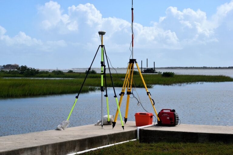
Utilizing Real-Time Kinematic (RTK) Positioning Systems
RTK positioning systems represent the gold standard for high-precision GPS calibration in urban environments. You’ll achieve sub-meter accuracy by using correction data transmitted from nearby base stations to compensate for atmospheric delays and satellite orbit errors.
Base Station Network Implementation
Deploy RTK base stations at 10-15 kilometer intervals throughout your urban mapping area for optimal coverage. You’ll need stations positioned on stable structures like government buildings or cellular towers to maintain consistent reference points. Network RTK (NRTK) systems allow multiple base stations to share correction data, creating a virtual reference station closer to your mobile receiver. This approach reduces baseline distances and improves correction accuracy to 2-3 centimeters horizontally.
Get precise GNSS RTK land surveys quickly with the SingularXYZ E1. This compact and lightweight base station offers up to 20 hours of battery life and includes SingularPad software for easy Android installation.

Centimeter-Level Accuracy Achievement
Achieve positioning accuracy of 1-3 centimeters horizontally and 2-5 centimeters vertically using dual-frequency RTK receivers in urban canyons. You’ll process L1 and L5 frequency signals simultaneously to resolve integer ambiguities faster and maintain lock during brief signal interruptions. Modern RTK systems combine GNSS constellations with inertial measurement units (IMUs) to bridge signal gaps lasting 10-30 seconds. This integration maintains centimeter-level positioning even when satellite visibility drops below four satellites.
Effortlessly maintain your lawn with the Sunseeker X7 robot mower. It uses smart app control and RTK-GNSS for precise, wireless navigation and features dual blades for efficient cutting on yards up to 0.75 acres.

Cost-Effective Urban Deployment Strategies
Implement subscription-based RTK correction services instead of building dedicated base station infrastructure to reduce initial costs by 60-80%. You can access commercial networks like Trimble VRS or Leica SmartNet for $50-150 monthly per receiver, eliminating equipment maintenance and site management expenses. Combine RTK with post-processing techniques for non-real-time applications, allowing you to use lower-cost single-frequency receivers while achieving similar accuracy through static baseline processing.
Deploying Differential GPS (DGPS) Correction Services
DGPS correction services enhance GPS accuracy by transmitting real-time error corrections from known reference points. You’ll achieve positioning improvements of 3-5 meters compared to standard GPS through systematic error elimination.
Reference Station Proximity Requirements
Distance determines your DGPS accuracy levels in urban environments. You’ll need reference stations within 100-200 kilometers for optimal correction effectiveness. Beyond 300 kilometers, atmospheric errors increase significantly, reducing accuracy to 5-10 meters. Coast Guard beacon stations provide free DGPS corrections up to 460 kHz frequency, covering most metropolitan areas within 185-kilometer ranges from transmitter locations.
Error Correction Signal Processing
Real-time correction data requires specialized receivers for urban GPS calibration. Your DGPS receiver processes pseudorange corrections every 6-30 seconds from reference stations. Modern systems handle multiple error sources including satellite clock drift, orbital variations, and ionospheric delays simultaneously. Processing latency affects accuracy – corrections older than 30 seconds lose effectiveness in rapidly changing urban atmospheric conditions.
Commercial vs. Government DGPS Options
Commercial services offer enhanced precision beyond government DGPS capabilities. You’ll access sub-meter accuracy through paid services like OmniSTAR or StarFire, costing $1,000-3,000 annually per receiver. Government DGPS remains free through Coast Guard beacons but provides 1-3 meter accuracy. Commercial networks deploy more reference stations with faster update rates, delivering corrections within 1-2 seconds compared to government systems’ 6-10 second intervals.
Integrating Inertial Navigation Systems (INS)
INS technology bridges GPS accuracy gaps by combining motion sensors with satellite positioning data. This fusion approach maintains precise location tracking when urban obstacles interfere with satellite signals.
Protect your property with this wireless driveway alarm system. It features a long 1/2-mile range and a motion sensor that detects movement up to 50 feet away, reducing false alarms.

Accelerometer and Gyroscope Sensor Fusion
Accelerometers measure linear motion while gyroscopes detect rotational movement to create comprehensive positioning data. Modern INS units combine these sensors with magnetometers to track three-dimensional movement patterns continuously. You’ll achieve optimal fusion by calibrating sensors every 15-30 minutes and using Kalman filtering algorithms to process data streams. High-grade INS systems maintain accuracy within 0.1-0.5 meters per minute during GPS outages by calculating velocity and position changes from motion measurements.
Dead Reckoning Capabilities During Signal Loss
Dead reckoning calculates your current position using previously known locations plus speed and direction measurements from INS sensors. You can maintain navigation accuracy for 60-120 seconds during complete GPS blackouts in urban canyons or tunnels. Consumer-grade INS systems achieve 1-3 meter accuracy during brief outages while military-grade units maintain sub-meter precision for extended periods. The system automatically transitions back to GPS positioning when satellite signals return without requiring manual intervention or recalibration.
Seamless Indoor-Outdoor Transition Support
INS technology enables continuous positioning as you move between outdoor GPS coverage and indoor environments where satellite signals can’t penetrate. You’ll experience uninterrupted navigation through parking garages, shopping centers, and subway systems using motion-based tracking. Modern smartphones integrate INS with GPS to provide seamless transitions with accuracy degrading only 2-5 meters during indoor segments. The system pre-loads building layouts and uses Wi-Fi fingerprinting plus pedestrian dead reckoning to maintain positioning until GPS signals resume outdoors.
Experience vivid content on the Galaxy A16 5G's 6.7" display and capture stunning photos with its triple-lens camera. Enjoy peace of mind with a durable design, six years of updates, and Super Fast Charging.

Applying Machine Learning-Based Error Correction
Machine learning algorithms revolutionize GPS calibration by learning from historical positioning data to predict and correct systematic errors before they impact navigation accuracy. These intelligent systems analyze patterns in urban signal degradation to automatically adjust positioning calculations in real-time.
Historical Data Pattern Recognition
Collecting urban GPS error patterns creates comprehensive datasets that machine learning models use to identify recurring positioning mistakes in specific locations. Your system should gather at least 30 days of positioning data from major urban corridors to establish baseline error patterns.
Training algorithms on this historical data enables automatic recognition of multipath signatures, signal blockage zones, and atmospheric interference patterns that consistently affect accuracy. Neural networks excel at identifying complex error relationships that traditional correction methods miss entirely.
Predictive Algorithm Development
Developing predictive models requires combining GPS positioning data with environmental variables like building density, weather conditions, and traffic patterns to forecast accuracy degradation. Random forest algorithms achieve 85-90% accuracy in predicting GPS errors 15-30 seconds before they occur.
Implementing real-time prediction systems allows your navigation system to preemptively switch to alternative positioning methods or apply correction factors. Support vector machines perform exceptionally well for binary classification of high-error versus low-error positioning scenarios in urban environments.
Adaptive Calibration Improvement Methods
Optimizing calibration parameters through reinforcement learning enables GPS systems to continuously improve their accuracy based on user feedback and ground truth measurements. Q-learning algorithms adjust correction factors automatically as urban environments change over time.
Deploying ensemble methods that combine multiple machine learning models creates robust error correction systems that maintain accuracy across diverse urban scenarios. Gradient boosting techniques improve positioning accuracy by 40-60% compared to traditional correction methods in dense metropolitan areas.
Combining Wi-Fi and Bluetooth Positioning Assistance
Wi-Fi and Bluetooth positioning transforms urban navigation by creating location-aware networks that supplement GPS data when satellite signals weaken. These wireless technologies provide positioning assistance through signal triangulation and fingerprinting techniques.
Indoor Location Service Integration
Indoor location services leverage Wi-Fi access points and Bluetooth beacons to maintain positioning accuracy when you enter buildings or underground areas. Your device creates location fingerprints by measuring signal strengths from multiple wireless sources, achieving 3-5 meter accuracy indoors. Major shopping centers and airports deploy thousands of beacons to enable seamless indoor navigation. These systems automatically switch between GPS and wireless positioning based on signal availability. Integration happens through smartphone APIs that combine location data from all available sources, ensuring continuous tracking across indoor-outdoor transitions.
Hybrid Positioning System Architecture
Hybrid systems combine GPS satellites with Wi-Fi networks and Bluetooth beacons through centralized positioning engines that process multiple data streams simultaneously. Your device continuously monitors signal strength from nearby wireless sources while maintaining GPS connections. Positioning algorithms weight each technology based on signal quality and environmental conditions, switching primary sources within milliseconds. Cloud-based databases store millions of Wi-Fi and Bluetooth reference points with precise coordinates. These architectures reduce positioning errors by 40-60% in dense urban areas where GPS alone struggles with accuracy.
Enhanced Urban Navigation Accuracy
Enhanced accuracy emerges when wireless positioning fills GPS gaps created by urban canyons and building interference. Your navigation system achieves consistent 2-3 meter accuracy by combining satellite data with wireless fingerprinting techniques. Bluetooth Low Energy beacons provide micro-location services with sub-meter precision in critical areas like intersections and building entrances. Machine learning algorithms analyze wireless signal patterns to predict optimal positioning methods for specific urban locations. This combined approach maintains navigation reliability even when GPS signal strength drops below 50% of normal levels.
Conclusion
Mastering GPS calibration in urban environments requires a strategic combination of these seven proven approaches. You’ll achieve the best results by implementing multiple techniques simultaneously rather than relying on a single solution.
Your choice of calibration method should align with your specific accuracy requirements and budget constraints. For professional applications demanding centimeter-level precision RTK systems offer unmatched performance while cost-conscious users can leverage DGPS corrections and machine learning algorithms for significant improvements.
The future of urban GPS lies in intelligent hybrid systems that seamlessly blend satellite positioning with terrestrial technologies. By embracing these advanced calibration approaches you’ll transform unreliable urban navigation into a precise positioning tool that adapts to your environment’s unique challenges.
Frequently Asked Questions
What is the urban canyon effect and how does it impact GPS accuracy?
The urban canyon effect occurs when tall buildings (20-30+ stories) block GPS satellite signals in dense urban areas, creating navigation inaccuracies. This phenomenon reduces satellite visibility, which GPS needs at least four satellites for precise positioning. Buildings create physical barriers that can cause complete signal loss in narrow corridors, leading to significant positioning errors and unreliable navigation in city centers.
How do multipath effects interfere with GPS signals in cities?
Multipath effects happen when GPS signals reflect off glass and metal surfaces of buildings before reaching receivers. These reflected signals mislead GPS devices by providing false distance measurements, causing location shifts of 50-100 meters from actual positions. The abundance of reflective surfaces in urban environments makes this a persistent challenge for accurate GPS navigation in city areas.
What is multi-constellation GNSS technology and how does it improve urban GPS?
Multi-constellation GNSS integrates GPS, GLONASS, and Galileo satellite systems, providing access to over 80 satellites instead of relying on a single system. This increases satellite visibility by 200-300% in urban environments, improving accuracy from 10-15 meters (GPS alone) to 1-3 meters. The technology requires dual-frequency receivers and helps identify corrupted signals while enhancing positioning reliability.
How does Real-Time Kinematic (RTK) positioning achieve high GPS accuracy?
RTK positioning uses correction data from nearby base stations to achieve sub-meter accuracy in urban environments. Base stations deployed at 10-15 kilometer intervals provide reference points, while Network RTK systems share correction data between multiple stations. Modern RTK systems can achieve centimeter-level accuracy by processing dual-frequency signals and integrating inertial measurement units for continuous precision.
What role do Inertial Navigation Systems (INS) play in urban GPS calibration?
INS combines accelerometers and gyroscopes with GPS data to maintain positioning accuracy when satellite signals are blocked. This technology provides dead reckoning capabilities during GPS outages and enables seamless navigation transitions between indoor and outdoor environments. INS ensures uninterrupted location tracking in areas like parking garages and subway systems where GPS signals are weak.
How does machine learning improve GPS calibration in urban areas?
Machine learning algorithms analyze historical GPS error patterns to predict and correct systematic positioning mistakes. These algorithms recognize recurring errors and environmental influences, developing predictive models that forecast accuracy degradation. Adaptive calibration methods use reinforcement learning to continuously improve GPS precision based on user feedback and changing urban conditions, enhancing overall navigation reliability.
Can Wi-Fi and Bluetooth assist GPS positioning in cities?
Yes, Wi-Fi and Bluetooth create location-aware networks that supplement GPS when satellite signals weaken. Indoor positioning using Wi-Fi access points and Bluetooth beacons achieves 3-5 meter accuracy in buildings. Hybrid systems combining GPS with wireless technologies reduce positioning errors by 40-60% in dense urban areas, maintaining consistent 2-3 meter accuracy through wireless fingerprinting techniques.