7 Best Cartography Tips for Creative Mapping
You’ve probably stared at a map and noticed something slightly off—maybe a building that’s moved or a road that doesn’t quite match reality. The reality: Perfect maps don’t exist and that’s actually a good thing for both cartographers and users alike.
Modern mapping technology pushes us toward pixel-perfect precision but embracing imperfection in map-making can lead to better user experiences more creative solutions and surprisingly effective navigation tools. The bottom line: Sometimes the most useful maps are the ones that deliberately leave out details prioritize clarity over accuracy or highlight what matters most to specific users.
Disclosure: As an Amazon Associate, this site earns from qualifying purchases. Thank you!
Imperfection Reflects the Dynamic Nature of Our World
Earth’s surface changes constantly, making perfectly accurate maps impossible to maintain. This inherent fluidity of our planet actually supports the argument for embracing imperfection in cartographic work.
P.S. check out Udemy’s GIS, Mapping & Remote Sensing courses on sale here…
Geographic Features Constantly Change Over Time
Rivers meander and carve new channels through sediment deposits, altering their paths seasonally or over decades. Coastlines erode from wave action and storm surge, while glacial retreat exposes new landforms. Vegetation boundaries shift with climate patterns, fire cycles, and human land use changes. Your maps capture a specific moment in time, but documenting these temporal variations through intentionally imperfect representations can communicate the dynamic nature of physical geography more effectively than static precision.
Human Settlements Evolve and Expand Continuously
Urban development occurs rapidly in growing metropolitan areas, with new subdivisions, commercial districts, and infrastructure appearing monthly. Population centers shift as economic opportunities change, creating ghost towns while establishing new communities. Transportation networks expand through highway construction, rail line additions, and airport developments. Your mapping approach should accommodate this constant urban flux by using generalized settlement patterns rather than attempting to capture every building or street modification in real-time updates.
Natural Disasters Reshape Landscapes Unpredictably
Earthquakes create fault scarps and trigger landslides that permanently alter topography and drainage patterns. Volcanic eruptions deposit new material, forming fresh landforms while destroying existing features. Flooding events carve new channels and deposit sediment across floodplains, changing surface elevation and land use capabilities. Wildfire burns modify vegetation cover and soil stability for years. Your maps gain authenticity by acknowledging these unpredictable changes rather than presenting landscapes as permanently fixed features.
Imperfection Encourages Creative Problem-Solving in Cartography
When you embrace imperfection in your mapping projects, you’ll discover that limitations become catalysts for innovation. Cartographic constraints force you to think beyond conventional solutions and develop unique approaches that often produce more effective visual communication.
Limited Data Forces Innovative Visualization Techniques
Incomplete datasets push you to develop creative representation methods that work with what’s available. You’ll find yourself combining partial satellite imagery with crowd-sourced data and field sketches to create comprehensive views. Techniques like interpolation algorithms, predictive modeling, and artistic interpretation help fill gaps where traditional data collection falls short. This approach often yields maps that capture local knowledge and community insights that pure technical data misses.
Constraints Spark Artistic Expression in Map Design
Budget restrictions and technical limitations inspire you to explore unconventional design solutions that enhance map clarity. Hand-drawn elements mixed with digital precision create distinctive visual styles that users remember and trust. Color palette restrictions force strategic choices that improve readability across different devices and printing methods. These creative compromises often result in more accessible maps that communicate complex geographic information through simplified yet powerful visual language.
Uncertainty Drives Development of New Mapping Methods
Ambiguous geographic boundaries and disputed territories challenge you to develop innovative representation techniques for contested spaces. You’ll experiment with transparency overlays, probability gradients, and multi-perspective views to show uncertainty rather than hide it. Dynamic mapping platforms allow real-time updates that acknowledge changing conditions instead of presenting false certainty. These methods help users understand the complexity of geographic reality while making informed decisions based on available evidence.
Imperfection Acknowledges the Limitations of Human Perspective
Every cartographer’s perspective is inherently limited by their cultural background, physical position, and available technology. These human constraints shape how we perceive and represent geographic space, making absolute objectivity impossible.
Cultural Biases Influence How We Interpret Space
Cultural worldviews shape your mapping decisions from color choices to feature prioritization. Western cartographic traditions emphasize property boundaries and roads, while indigenous mapping systems often highlight seasonal patterns and resource flows. Your cultural background affects which geographic features you consider important, how you label places, and even your orientation preferences. These biases aren’t necessarily negative—they reflect different ways of understanding and interacting with landscapes that can provide valuable insights.
Scale Restrictions Prevent Perfect Representation
Scale limitations force you to make selective choices about what geographic information to include. A 1:24,000 topographic map can’t show every boulder or tree, requiring generalization that introduces deliberate imperfection. You must prioritize certain features over others based on your map’s intended purpose. Street maps emphasize navigation networks while geological maps highlight rock formations. These scale-driven compromises create specialized representations that serve specific user needs rather than attempting comprehensive accuracy.
Observer Position Affects Geographic Understanding
Your physical viewpoint fundamentally shapes geographic interpretation through elevation, distance, and timing constraints. Satellite imagery provides one perspective while ground-level surveys offer another, each revealing different spatial relationships. You can’t simultaneously observe a landscape from all possible angles or capture every temporal variation. Weather conditions, seasonal changes, and accessibility limitations further restrict your observational capacity. These positional constraints create maps that reflect specific moments and viewpoints rather than universal geographic truth.
Imperfection Promotes Inclusive and Diverse Mapping Approaches
Embracing imperfection in cartography opens doors to mapping methodologies that prioritize community voices and diverse perspectives over traditional precision standards.
Community-Based Mapping Captures Local Knowledge
Community-based mapping projects leverage residents’ intimate understanding of their neighborhoods to create maps that reflect lived experiences rather than sterile datasets. You’ll find these grassroots initiatives often reveal informal pathways, cultural landmarks, and social boundaries invisible to conventional surveying methods. Local participants contribute knowledge about seasonal flooding patterns, community gathering spaces, and historical significance that GPS coordinates alone can’t capture. These imperfect but richly detailed maps serve planning decisions more effectively than technically precise alternatives lacking contextual depth.
Participatory Cartography Values Multiple Viewpoints
Participatory cartography acknowledges that single-perspective mapping inherently excludes valuable insights from diverse user groups. You can observe how these collaborative approaches intentionally incorporate conflicting viewpoints and overlapping territorial claims rather than forcing artificial consensus. Multiple stakeholders contribute different spatial knowledge through workshops, mobile mapping apps, and community forums. The resulting maps display contested boundaries, alternative place names, and varying land use interpretations that reflect real-world complexity. This inclusive methodology produces maps that better serve multicultural communities and complex governance situations.
Indigenous Mapping Traditions Offer Alternative Perspectives
Indigenous mapping traditions demonstrate sophisticated spatial knowledge systems that prioritize relationships, seasonal cycles, and cultural connections over geometric accuracy. You’ll discover these approaches often emphasize temporal changes, spiritual significance, and ecological interconnections through artistic elements and oral narratives integrated into cartographic representations. Traditional knowledge holders contribute understanding of migration patterns, resource availability, and sacred sites that Western mapping conventions typically overlook. These culturally-grounded maps challenge standard cartographic assumptions while preserving essential environmental and cultural information for future generations.
Imperfection Enhances User Engagement Through Interactivity
Interactive mapping platforms demonstrate how deliberate imperfections create more engaging user experiences than static, “complete” maps.
Incomplete Maps Invite Exploration and Discovery
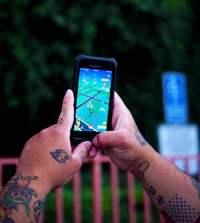
Intentionally sparse maps encourage users to become active participants in the discovery process. OpenStreetMap’s early coverage gaps motivated millions of volunteers to contribute local knowledge, transforming mapping from passive consumption to active exploration. You’ll find that leaving certain areas deliberately undefined prompts users to investigate further, creating natural curiosity loops that traditional complete maps can’t match. Gaming applications like Pokémon GO leverage this principle by revealing map details only through user movement and interaction.
User-Generated Content Improves Map Accuracy Over Time
Crowdsourced mapping platforms harness collective intelligence to continuously refine geographic data accuracy. Waze users report real-time traffic incidents, road closures, and new construction, creating maps that evolve faster than any professional survey team could manage. You benefit from this iterative improvement process where initial imperfections become starting points for community-driven accuracy. Google Maps’ “suggest an edit” feature processes over 20 million user contributions monthly, demonstrating how imperfect base maps generate superior long-term results through collaborative refinement.
Collaborative Mapping Projects Build Community Connections
Community-driven mapping initiatives transform imperfect geographic data into powerful social organizing tools. Crisis mapping efforts during natural disasters rely on incomplete initial information that local volunteers rapidly enhance with ground-truth observations, creating both accurate maps and stronger community networks. You’ll discover that projects like Missing Maps engage humanitarian volunteers worldwide, turning cartographic imperfections into opportunities for meaningful collaboration. These initiatives prove that acknowledging mapping limitations fosters stronger community participation than presenting authoritative but potentially outdated “perfect” maps.
Imperfection Reduces Production Costs and Time Constraints
Modern cartographic workflows often consume excessive resources pursuing absolute accuracy when functional precision would serve users better. Embracing calculated imperfection transforms mapping economics by reducing both financial overhead and production bottlenecks.
Accepting Minor Errors Speeds Up Publishing Timelines
Publishing deadlines become achievable when you’re not obsessing over microscopic details. Traditional quality control processes can extend project timelines by 40-60% while hunting for perfection that users rarely notice. Field verification trips for minor coordinate adjustments consume weeks of valuable time. You’ll discover that releasing maps with acceptable accuracy levels meets user needs while keeping projects on schedule. Emergency response mapping particularly benefits from this approach, where timely information trumps perfect precision.
Simplified Details Lower Resource Requirements
Resource allocation becomes more efficient when you prioritize essential cartographic elements over exhaustive detail. High-resolution satellite imagery costs $15-25 per square kilometer, while medium-resolution alternatives provide adequate detail for most applications at half the price. Automated generalization tools reduce manual drafting hours by 70% compared to hand-digitizing every geographic feature. You can redirect saved resources toward user testing and iterative design improvements. Simplified symbology also reduces printing costs and improves map readability across different output formats.
Iterative Updates Allow for Gradual Improvement
Iterative workflows enable continuous enhancement without massive upfront investments in perfect accuracy. You can launch initial map versions with 80% completeness and refine problematic areas based on user feedback. Web-based platforms like MapBox and ArcGIS Online support seamless updates without republishing entire datasets. Crowdsourced corrections through platforms like OpenStreetMap provide cost-effective accuracy improvements over time. This approach spreads production costs across multiple update cycles while maintaining user engagement through visible improvements.
Imperfection Teaches Valuable Lessons About Uncertainty and Adaptation
Mapping challenges force you to confront the reality that geographic knowledge evolves continuously. Working with imperfect data prepares you for real-world navigation scenarios where conditions change unpredictably.
Maps as Learning Tools Rather Than Perfect References
Maps function best as educational instruments that reveal spatial relationships rather than definitive authorities. When you encounter inconsistencies between different map sources, you develop skills in cross-referencing information and evaluating data quality. Field verification becomes essential as you learn to question mapping assumptions and ground-truth geographic features. This approach transforms passive map reading into active geographic investigation, where you analyze terrain patterns, settlement distributions, and infrastructure networks to understand underlying geographic processes rather than simply accepting presented information.
Critical Thinking Skills Developed Through Map Analysis
Analyzing imperfect maps sharpens your ability to identify data gaps and potential inaccuracies. You learn to recognize projection distortions that affect distance and area measurements, particularly when comparing maps using different coordinate systems. Evaluating symbol consistency helps you spot classification errors in feature representations. Temporal analysis skills develop as you compare historical maps with current conditions, revealing how landscapes evolve over time. These analytical practices prepare you to work with uncertain datasets in professional mapping projects where perfect information rarely exists.
Explore history's most significant maps with *Great Maps*. This book delves into cartographic masterpieces and their historical context.

Flexibility in Navigation and Spatial Understanding
Working with imperfect maps builds adaptive navigation skills that prove invaluable in challenging environments. You develop backup strategies when primary routes become inaccessible due to construction, weather, or seasonal changes. Multi-source navigation techniques emerge as you learn to combine GPS data with topographic maps and local knowledge. This flexibility extends to spatial reasoning, where you interpret incomplete boundary information and estimate distances when precise measurements aren’t available. These skills prove essential in emergency response situations where rapid decision-making with limited information can determine mission success.
Learn essential map reading and navigation skills with this U.S. Army guide. Designed for practical use, it provides clear instructions for navigating any terrain.

Conclusion
Your journey through imperfect cartography reveals that the most valuable maps aren’t necessarily the most precise ones. When you embrace mapping limitations you unlock creative solutions that serve real-world needs better than pursuing impossible perfection.
The dynamic nature of our world means your maps will always be works in progress. Rather than seeing this as a flaw you can view it as an opportunity to create more engaging interactive experiences that invite exploration and community participation.
By accepting imperfection in your mapping projects you’ll develop more efficient workflows reduce costs and foster inclusive approaches that capture diverse perspectives. These “flawed” maps often become more educational tools that build critical thinking skills and adaptive navigation abilities.
The path forward isn’t about abandoning accuracy—it’s about recognizing when good enough is actually better. Your willingness to embrace mapping imperfections will ultimately lead to more meaningful and effective geographic representations.
Frequently Asked Questions
Why are perfect maps impossible to achieve?
Perfect maps are unattainable because Earth’s surface constantly changes due to natural processes like erosion, volcanic activity, and weather patterns. Rivers shift course, coastlines erode, and human settlements evolve rapidly through urban development. Natural disasters unpredictably reshape landscapes, while seasonal variations affect geographic features. Additionally, every cartographer’s perspective is influenced by their cultural background and available technology, making absolute objectivity impossible in mapping.
How can imperfect maps benefit users more than perfect ones?
Imperfect maps encourage active exploration and critical thinking rather than passive consumption. They invite users to engage with their environment, develop navigation skills, and cross-reference multiple sources. Interactive platforms with intentionally sparse coverage motivate community contributions, creating more comprehensive and locally relevant maps. This approach transforms users from passive consumers into active participants in the mapping process.
What role does cultural perspective play in cartography?
Cultural background significantly influences mapping decisions, as different traditions emphasize various geographic features based on their values and needs. What one culture considers important landmarks, another might overlook entirely. Indigenous mapping traditions, for example, prioritize relationships and cultural connections over geometric accuracy, showcasing sophisticated spatial knowledge systems that challenge standard cartographic assumptions and preserve essential cultural information.
How does embracing imperfection reduce mapping costs?
Accepting minor inaccuracies speeds up publishing timelines by eliminating lengthy quality control processes that can extend project durations significantly. Simplifying details reduces resource requirements, allowing better allocation toward user testing and design improvements. Iterative updates enable continuous enhancement without massive upfront investments, spreading production costs across multiple cycles while maintaining user engagement through gradual improvements based on feedback.
Why is community-based mapping more effective than traditional methods?
Community-based mapping leverages residents’ intimate understanding of their neighborhoods, capturing lived experiences that conventional methods often miss. Local contributors reveal informal pathways, cultural landmarks, and neighborhood nuances that satellite imagery cannot detect. This participatory approach incorporates multiple viewpoints from various stakeholders, producing maps that better serve multicultural communities and reflect actual usage patterns rather than theoretical geographic representations.
How do imperfect maps enhance learning and critical thinking?
Working with imperfect maps forces users to develop critical evaluation skills by comparing multiple sources and identifying inconsistencies. This process transforms passive map reading into active geographic investigation, where users analyze terrain patterns, evaluate data quality, and cross-reference information. These skills are essential for emergency response situations where rapid decision-making with limited information can determine success.
What advantages do iterative mapping updates provide?
Iterative updates allow continuous map improvement based on real user feedback and crowdsourced corrections. This approach maintains user engagement while spreading development costs across multiple cycles. Maps can evolve gradually, incorporating new information and fixing errors over time. Platforms like OpenStreetMap and Waze demonstrate how community contributions continuously refine geographic data, creating more accurate and relevant mapping resources.
How does imperfection foster innovation in cartography?
Mapping limitations drive creative problem-solving and innovative visualization techniques. Budget constraints inspire unique design solutions that enhance clarity, while incomplete datasets encourage combining traditional mapping with crowd-sourced data and artistic interpretation. Uncertainty in geographic boundaries leads to new mapping methods that acknowledge complexity rather than concealing it, often resulting in more effective and meaningful geographic representations.