7 Best Disaster Mapping Tools for Remote Areas
When disaster strikes remote locations you face a critical challenge: how do you assess damage and coordinate relief efforts in areas where traditional access is impossible? Geographic isolation mountainous terrain and infrastructure collapse create information blackouts that delay life-saving responses.
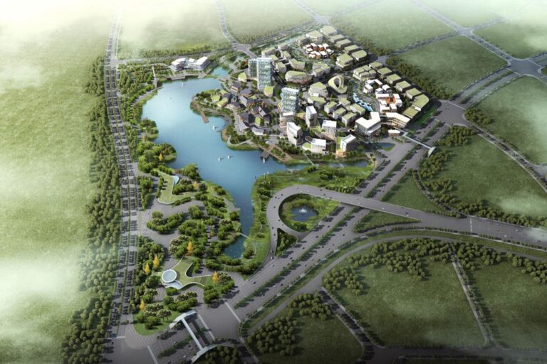
Modern mapping technologies are revolutionizing disaster response by providing real-time intelligence from the most inaccessible regions. You can now leverage satellite imagery drone surveillance and community-based reporting systems to create comprehensive damage assessments without boots on the ground.
This technological shift means you’ll get faster more accurate data that drives better decision-making when every minute counts in disaster recovery operations.
Disclosure: As an Amazon Associate, this site earns from qualifying purchases. Thank you!
P.S. check out Udemy’s GIS, Mapping & Remote Sensing courses on sale here…
Understanding the Challenges of Mapping Disaster Impacts in Remote Locations
Remote disaster mapping presents unique obstacles that traditional surveying methods can’t overcome. You’ll encounter barriers that require specialized approaches and alternative data collection strategies.
Geographic and Terrain Barriers
Mountainous terrain creates significant access limitations for ground-based mapping teams during disaster response operations. You’ll face steep slopes, unstable rockfall zones, and weather-dependent visibility that prevent direct observation of affected areas. Rivers, canyons, and dense forests further isolate impact zones from conventional survey methods. Arctic regions present extreme cold conditions that disable standard equipment, while desert environments create sandstorm interference with optical instruments. Elevation changes of 3,000+ feet within small areas make aerial photography challenging and require specialized flight planning techniques.
Limited Infrastructure and Communication Networks
Destroyed communication towers eliminate real-time data transmission from remote disaster zones to coordination centers. You’ll encounter collapsed bridges that cut off vehicle access routes, while damaged power grids prevent equipment charging and operation. Rural areas often lack cellular coverage even before disasters, creating information blackouts spanning hundreds of square miles. Satellite internet costs $500-2,000 monthly in remote locations, making continuous connectivity financially prohibitive for many mapping operations. Road washouts and runway damage further restrict equipment deployment to affected regions.
Security and Political Constraints
Armed conflict zones require security escorts that limit mapping team movement and data collection windows. You’ll need government permits that take weeks to obtain, delaying critical disaster assessment activities. Border regions involve multiple jurisdictions with conflicting authority structures and documentation requirements. Restricted airspace regulations prohibit drone flights within 5 miles of military installations or sensitive infrastructure. Political instability creates evacuation risks that force mapping teams to withdraw before completing comprehensive surveys of disaster impacts.
Leveraging Satellite Imagery and Remote Sensing Technology
Modern satellite platforms provide critical mapping capabilities when ground access becomes impossible. You’ll find these space-based sensors deliver comprehensive coverage of affected areas within hours of a disaster event.
High-Resolution Satellite Data Collection
Commercial satellites like WorldView-3 and GeoEye-1 capture imagery at 0.3-meter resolution, revealing individual structures and infrastructure damage patterns. You can access near real-time data through platforms like Planet Labs or Maxar’s SecureWatch, which offer daily coverage updates. Emergency response teams rely on change detection analysis comparing pre- and post-disaster imagery to quantify structural collapse, debris distribution, and blocked transportation routes in mountainous or isolated regions.
Synthetic Aperture Radar (SAR) Applications
SAR technology penetrates cloud cover and operates during nighttime conditions, making it invaluable for continuous disaster monitoring. You’ll use Sentinel-1 or RADARSAT-2 data to detect ground deformation, flooding extent, and landslide activity through interferometric analysis. SAR’s ability to measure surface changes at millimeter precision helps you identify unstable terrain and assess infrastructure integrity when optical sensors can’t function due to weather constraints or atmospheric interference.
Multispectral and Hyperspectral Imaging
Multispectral sensors capture data across visible and infrared wavelengths, enabling you to classify vegetation stress, water contamination, and material composition changes. Landsat-8 and Sentinel-2 provide free access to 10-30 meter resolution imagery with 16-day revisit cycles. You’ll analyze normalized difference vegetation index (NDVI) values to assess agricultural damage and use thermal bands to identify heat signatures from fires or exposed geological materials in remote terrain.
Explore multispectral image sensors using metasurfaces. This book delves into advancements in optical science and photonics.

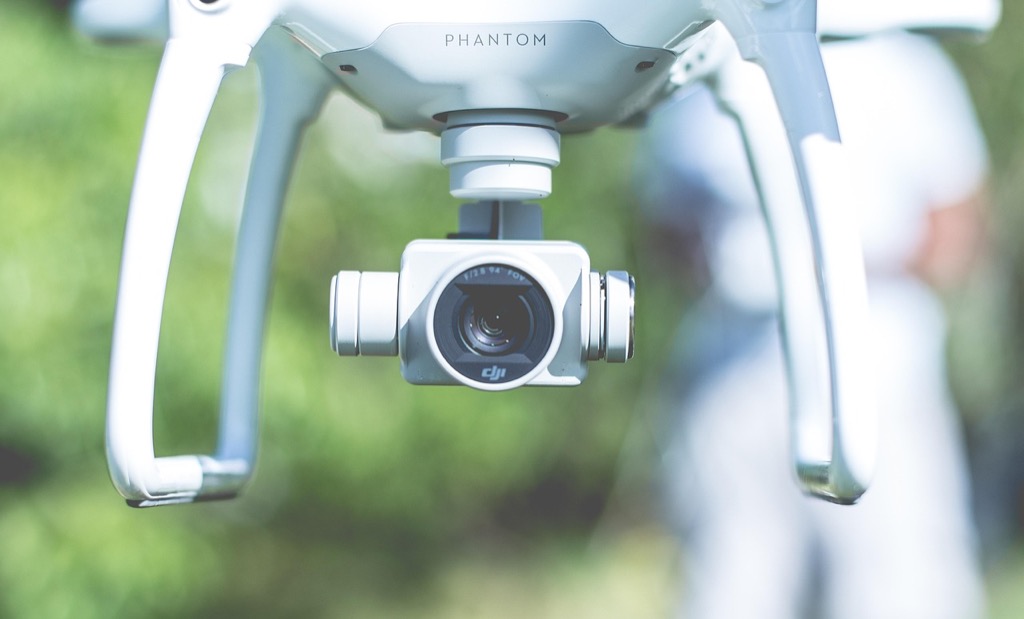
Utilizing Unmanned Aerial Vehicles (UAVs) for Damage Assessment
UAVs bridge the gap between satellite imagery limitations and ground-based survey constraints in disaster-affected areas. These versatile platforms deliver high-resolution mapping data while maintaining operational flexibility in challenging terrain conditions.
Drone Deployment Strategies
Deploy UAVs in systematic grid patterns to ensure complete coverage of affected areas without data gaps. Fixed-wing drones like the senseFly eBee X cover up to 500 hectares per flight with 2-3 cm ground resolution, making them ideal for large-scale damage surveys. Multi-rotor platforms such as the DJI Matrice 300 RTK provide superior maneuverability around structures and debris, enabling detailed infrastructure assessments in confined spaces.
Capture stunning 4K HDR video with this lightweight drone, perfect for social media with its True Vertical Shooting mode. It offers stable footage in windy conditions thanks to its 3-axis gimbal and features beginner-friendly controls like GPS Return to Home.

Real-Time Data Transmission Capabilities
Stream live video feeds directly to emergency operations centers using cellular or satellite communication links. Modern UAV platforms equipped with 4G LTE modems transmit orthomosaic imagery and thermal data within minutes of capture. The Autel EVO Max 4T processes imagery onboard using AI algorithms, automatically detecting structural damage and transmitting priority areas for immediate response coordination.
The Autel EVO Max 4T V2 drone offers advanced imaging with its wide, zoom, thermal cameras, and laser rangefinder. It features 720° obstacle avoidance, A-Mesh networking for superior anti-interference, and battery in-place detection for enhanced safety.

Cost-Effective Coverage of Large Areas
Generate comprehensive damage maps at 90% lower cost compared to traditional aerial surveys or helicopter reconnaissance. A single UAV mission covering 1,000 acres costs approximately $2,000-3,000 versus $15,000-20,000 for manned aircraft operations. Automated flight planning software like Pix4Dcapture optimizes survey routes, reducing flight time by 40% while maintaining consistent overlap ratios for accurate photogrammetric reconstruction.
Implementing Crowdsourcing and Community-Based Mapping
When traditional mapping methods fail in disaster-affected areas, local communities become your most valuable data collection assets. Community-based mapping harnesses the collective knowledge of residents who understand their terrain intimately and can provide real-time ground truth verification.
Mobile Data Collection Applications
Deploy smartphone-based mapping apps that work offline to enable local data collectors in areas with compromised connectivity. KoBo Toolbox and ODK Collect allow you to create custom forms for damage assessment that sync automatically when internet access returns. These applications capture GPS coordinates, photos, and structured data even when cellular networks are down.
Experience vivid content on the Galaxy A16 5G's 6.7" display and capture stunning photos with its triple-lens camera. Enjoy peace of mind with a durable design, six years of updates, and Super Fast Charging.

Distribute pre-loaded devices to community volunteers with standardized data collection protocols. Apps like Survey123 and Fulcrum provide intuitive interfaces that require minimal training while ensuring data quality through built-in validation rules and standardized field formats.
Local Knowledge Integration
Establish community mapping workshops before disasters strike to train local residents in basic GIS data collection techniques. Community members possess irreplaceable knowledge about local infrastructure, evacuation routes, and vulnerable populations that external teams cannot quickly acquire.
Create participatory mapping sessions where locals sketch damage assessments on printed base maps or tablets. This approach captures cultural landmarks, informal settlements, and community assets that don’t appear in official datasets but are crucial for effective disaster response coordination.
Validate crowdsourced data through cross-referencing multiple community reports and comparing them with available satellite imagery to ensure accuracy and reliability of locally-generated information.
Social Media and Citizen Reporting
Monitor geotagged social media posts from platforms like Twitter, Facebook, and Instagram to identify disaster impacts in real-time. Tools like Ushahidi and CrisisMappers aggregate citizen reports into actionable intelligence for emergency responders.
Establish official hashtags and reporting channels that direct social media users to contribute structured information rather than random posts. This approach helps filter relevant damage reports from general disaster commentary.
Implement verification protocols for social media data by cross-referencing timestamps, locations, and photo metadata to distinguish authentic reports from misinformation or outdated content that could misdirect response efforts.
Establishing Ground Truth Through Field Verification Teams
While remote sensing provides comprehensive coverage, you’ll need field verification teams to validate your satellite and drone data accuracy. These teams serve as your critical link between technological assessments and on-ground reality.
Strategic Team Deployment Planning
Deploy verification teams using a hub-and-spoke model from established base camps to maximize coverage efficiency. You’ll want to position teams at strategic locations that provide access to multiple affected zones within a 15-kilometer radius. Coordinate deployment timing with optimal weather windows and leverage local transportation networks like motorcycles or all-terrain vehicles for rapid movement. Pre-identify evacuation routes and communication checkpoints before teams enter remote areas. Establish rotating schedules that allow continuous field presence while preventing team fatigue during extended operations.
Safety Protocols and Risk Management
Implement comprehensive safety protocols including mandatory satellite communication devices for each team member operating in remote zones. You’ll need to establish check-in procedures every 4-6 hours with base operations and create detailed risk assessment matrices for different terrain types. Require hazmat training for teams entering areas with potential chemical contamination or structural collapse risks. Maintain emergency medical supplies and ensure team members receive wilderness first aid certification. Coordinate with local emergency services to establish rapid response protocols for team extraction if conditions deteriorate.
Stay connected globally with the ACR Bivy Stick. This satellite communicator offers two-way SMS, GPS tracking, and SOS emergency support via the Iridium network.

Data Quality Control Measures
Establish standardized data collection protocols using GPS-enabled mobile devices with offline mapping capabilities to ensure consistent field measurements. You’ll want to implement cross-verification procedures where teams photograph damage indicators and record precise coordinates for each assessment point. Create validation checklists that compare field observations against satellite imagery interpretations to identify discrepancies. Require teams to collect redundant measurements at 10% of assessment locations and establish real-time data transmission protocols for immediate quality checks by remote analysts.
Integrating Geographic Information Systems (GIS) for Comprehensive Analysis
GIS platforms transform fragmented disaster data into cohesive spatial intelligence for remote area mapping. You’ll consolidate multiple data streams into unified assessment frameworks that support critical decision-making.
Multi-Source Data Integration
Combine satellite imagery, drone data, and field reports within GIS platforms like ArcGIS Pro or QGIS for unified analysis. You’ll merge vector datasets from crowdsourced mapping with raster imagery from commercial satellites to create comprehensive damage assessments. Standardize coordinate systems using WGS84 projections to ensure spatial accuracy across different data sources. Attribute each dataset with collection timestamps and confidence levels to maintain data quality during integration processes.
Spatial Analysis and Modeling
Execute proximity analysis to identify affected populations within disaster impact zones using buffer tools and overlay operations. You’ll apply hotspot analysis through Getis-Ord Gi* statistics to detect damage clustering patterns in remote terrain. Generate risk models by combining elevation data with infrastructure layers to predict secondary hazards like landslides or flooding. Calculate accessibility indices using network analysis tools to determine optimal evacuation routes and supply distribution points.
Interactive Mapping Platforms
Deploy web-based dashboards using ArcGIS Online or Leaflet libraries to share real-time disaster intelligence with response teams. You’ll configure map services that automatically update as new field data arrives through mobile collection apps. Customize symbology and pop-up windows to display damage severity levels and resource requirements for each affected area. Enable collaborative editing features allowing multiple field teams to contribute updates simultaneously while maintaining version control.
Developing Partnerships with Local Organizations and Authorities
Successful disaster mapping in remote areas depends heavily on your ability to forge strategic partnerships with local stakeholders who possess critical knowledge and access capabilities.
Building Trust with Community Leaders
Building trust with local leaders requires you to demonstrate genuine respect for their expertise and decision-making authority within their communities. You’ll need to invest time in face-to-face meetings where you can explain your mapping objectives while actively listening to their concerns about privacy and data use. Successful partnerships develop when you acknowledge that community leaders understand local terrain features, population vulnerabilities, and cultural sensitivities that aren’t visible in satellite imagery. You should establish clear protocols for data sharing that protect community interests while meeting your mapping requirements. Creating formal agreements that outline mutual benefits helps maintain trust throughout the disaster response period.
Coordinating with Emergency Response Teams
Coordinating with emergency response teams ensures your mapping efforts align with active relief operations and avoid duplicating existing data collection activities. You’ll need to integrate your mapping timeline with established emergency management protocols while maintaining communication channels that allow for real-time data sharing. Most effective coordination happens when you participate in regular briefings where you can provide updated damage assessments while receiving priority area assignments from incident commanders. You should establish standardized data formats that match emergency response systems to ensure your mapping products can be immediately utilized for decision-making. Creating shared access to your mapping platforms allows response teams to contribute field observations that enhance your remote assessments.
Establishing Long-Term Collaboration Networks
Establishing long-term collaboration networks creates sustainable partnerships that extend beyond immediate disaster response into preparedness and recovery phases. You’ll want to develop memorandums of understanding with local authorities that define roles and responsibilities for future disaster mapping activities while ensuring data access agreements remain current. Successful networks include regular training sessions where you can teach local partners to use mapping tools while learning about their evolving needs and capabilities. You should create redundant communication systems that maintain connectivity during emergencies while building local capacity to continue mapping efforts independently. These partnerships become most valuable when you establish ongoing relationships that support both pre-disaster vulnerability assessments and post-disaster recovery monitoring.
Creating Standardized Data Collection and Reporting Protocols
Establishing consistent data collection methods ensures your disaster mapping efforts produce reliable, comparable results across different response teams and geographic regions.
Unified Assessment Frameworks
Standardized assessment frameworks provide consistent damage classification systems across all mapping teams and data sources. You’ll achieve better coordination by implementing universal damage scales like the EMS-98 earthquake intensity scale or FEMA’s Preliminary Damage Assessment categories. These frameworks ensure satellite analysts, drone operators, and field teams use identical terminology when reporting structural damage levels. Pre-defined attribute tables streamline data entry while maintaining consistency across multiple collection platforms and team members.
Quality Assurance Standards
Quality control protocols guarantee your mapping data meets professional accuracy standards before integration into emergency response systems. You’ll implement mandatory cross-verification procedures requiring two independent assessments for critical infrastructure damage reports. Statistical sampling methods help validate crowdsourced data by comparing random samples against verified field observations. Your quality assurance checklist should include positional accuracy tolerances, attribute completeness thresholds, and temporal currency requirements for all collected data.
Interoperable Data Formats
Standardized file formats enable seamless data sharing between different mapping platforms and emergency response organizations. You’ll prioritize open standards like GeoJSON, KML, and Esri Shapefile formats that work across multiple GIS software packages. Metadata schemas following ISO 19115 standards ensure your datasets include essential information about collection methods, accuracy levels, and update timestamps. This interoperability allows relief organizations to quickly integrate your mapping data into their existing decision-support systems.
Ensuring Data Security and Ethical Considerations
Your disaster mapping operations in remote areas must balance urgent response needs with rigorous protection of sensitive information and affected communities.
Privacy Protection Measures
Implement location obfuscation techniques when mapping residential areas to prevent individual identification. Use coordinate rounding to 100-meter grids rather than precise GPS points for household damage assessments. Deploy encrypted data transmission protocols for all remote sensing uploads, ensuring satellite imagery containing identifiable structures remains protected. Establish data retention policies limiting storage duration to active response periods plus six months maximum. Configure mapping platforms with role-based access controls, restricting detailed damage assessments to authorized emergency personnel only.
Informed Consent Procedures
Establish clear consent protocols before engaging local communities in crowdsourced mapping activities. Develop multilingual consent forms explaining data usage, storage duration, and sharing arrangements with response agencies. Train field verification teams to obtain verbal consent using standardized scripts when documenting property damage. Create opt-out mechanisms allowing residents to exclude their properties from detailed mapping coverage. Document consent status within your GIS database using dedicated attribute fields, ensuring compliance tracking throughout the response operation.
Sensitive Information Handling
Classify data sensitivity levels using standardized frameworks before integration into mapping systems. Separate personally identifiable information from spatial datasets, storing demographic data in encrypted databases with restricted access. Apply differential privacy techniques when aggregating community-level damage statistics for public reporting. Establish secure data transfer protocols for sharing assessments with international aid organizations, using end-to-end encryption and digital signatures. Implement automated data purging systems removing sensitive identifiers after predetermined retention periods while preserving anonymized spatial intelligence for future preparedness planning.
Conclusion
Mapping disaster impacts in hard-to-reach areas requires a strategic blend of cutting-edge technology and community collaboration. You’ll achieve the most effective results when you combine satellite imagery and drone surveillance with local knowledge and crowdsourced reporting.
Your success depends on building strong partnerships with local organizations while maintaining rigorous data security protocols. Remember that standardized collection methods and proper field verification will ensure your mapping efforts translate into actionable intelligence for response teams.
The investment in these comprehensive mapping strategies pays dividends through faster response times and more targeted relief efforts. You’re not just collecting data â you’re creating a foundation for saving lives and rebuilding communities in the world’s most challenging environments.
Achieve a flawless, even complexion with e.l.f. Flawless Satin Foundation. This lightweight, vegan formula provides medium coverage and a semi-matte finish for all-day wear, while hydrating your skin with glycerin.

Frequently Asked Questions
What are the main challenges in mapping disaster damage in remote locations?
Remote disaster mapping faces significant obstacles including geographic isolation, destroyed infrastructure, and limited communication networks. Mountainous terrain and extreme weather conditions prevent traditional ground-based assessments. Security concerns in conflict zones further restrict access, while collapsed roads and bridges make equipment deployment nearly impossible. These factors require specialized technological solutions and alternative data collection strategies.
How do satellites help in disaster mapping when ground access is impossible?
Modern satellite platforms provide comprehensive coverage of disaster-affected areas within hours, delivering high-resolution imagery for damage assessment. Advanced satellites like WorldView-3 use change detection analysis to identify structural damage and blocked routes. Synthetic Aperture Radar (SAR) technology enables continuous monitoring even in bad weather, while multispectral imaging helps assess vegetation stress and water contamination.
What role do drones play in disaster damage assessment?
Drones bridge the gap between satellite limitations and ground survey constraints by providing detailed, real-time aerial assessments. They use systematic grid patterns for complete area coverage and can transmit live video feeds for immediate response coordination. UAVs are cost-effective alternatives to traditional aerial surveys, with AI-powered processing capabilities that generate comprehensive damage maps efficiently.
How can local communities contribute to disaster mapping efforts?
Local communities provide invaluable real-time data through their intimate knowledge of the terrain and current conditions. Using mobile apps like KoBo Toolbox, residents can collect damage assessments even without internet connectivity. Community mapping workshops train locals in GIS data collection techniques, while social media platforms with geotagged posts offer additional intelligence sources for disaster response teams.
What are the key components of effective field verification teams?
Effective field verification teams require strategic deployment using hub-and-spoke models for maximum coverage efficiency. Essential safety protocols include mandatory satellite communication devices, regular check-ins, and comprehensive risk management training. Teams must follow standardized data collection protocols and cross-verification procedures to ensure accuracy while maintaining constant communication with coordination centers.
How do GIS systems integrate different data sources for disaster response?
GIS platforms combine satellite imagery, drone data, and field reports into unified damage assessments for comprehensive spatial analysis. They enable proximity analysis to identify affected populations and hotspot analysis to detect damage clustering patterns. Interactive mapping platforms allow real-time sharing of disaster intelligence, facilitating collaborative updates and enhanced situational awareness among response teams.
Why are partnerships with local organizations crucial for disaster mapping?
Local partnerships provide essential cultural knowledge, community trust, and logistical support that external teams cannot access independently. Community leaders offer expertise about local terrain and population dynamics while facilitating smoother data collection processes. Formal agreements ensure mutual benefits and sustainable collaboration networks that extend beyond immediate disaster response into long-term preparedness and recovery phases.
What data security measures are necessary in disaster mapping operations?
Data security requires implementing privacy protection measures such as location obfuscation techniques and encrypted transmission protocols to prevent individual identification. Informed consent procedures must include multilingual forms and opt-out mechanisms for community participation. Data classification systems help identify sensitivity levels, while secure handling practices protect personally identifiable information throughout the mapping process.