7 Unconventional Printed Map Formats That Transform Traditional Cartography
You’ve probably seen countless traditional wall maps and folded road atlases, but the world of printed cartography extends far beyond these familiar formats. Creative mapmakers are pushing boundaries with innovative designs that transform how we interact with geographic information.
Plan your next road trip with the Rand McNally 2026 Large Scale Road Atlas. Featuring detailed maps of the United States, Canada, and Mexico, this atlas offers comprehensive coverage for easy navigation.

From wearable navigation accessories to interactive puzzle maps, these unconventional formats make geography more engaging and accessible than ever before.
Disclosure: As an Amazon Associate, this site earns from qualifying purchases. Thank you!
Fabric Maps: Durable and Portable Cartographic Solutions
Fabric maps represent a revolutionary approach to cartographic durability, combining traditional mapping with textile engineering. You’ll find these solutions particularly valuable when standard paper maps can’t withstand harsh environmental conditions.
P.S. check out Udemy’s GIS, Mapping & Remote Sensing courses on sale here…
Waterproof and Tear-Resistant Materials
Ripstop nylon and polyester blend fabrics deliver exceptional durability for field mapping applications. You can rely on these materials to maintain cartographic accuracy even after repeated folding cycles and exposure to moisture. Modern synthetic textiles resist UV degradation while preserving color fidelity across topographic features. Canvas and sailcloth options provide heavyweight alternatives that withstand extreme outdoor conditions without compromising map detail clarity.
Lightweight Design for Outdoor Adventures
Ultra-lightweight polyester maps weigh 60-80% less than laminated paper equivalents while maintaining full cartographic detail. You’ll appreciate how these compact designs fold to pocket-size dimensions without creating permanent creases that obscure critical navigation information. Microfiber constructions offer excellent packability for backpacking expeditions where every ounce matters. Quick-dry properties ensure your maps remain functional after rain exposure or stream crossings during extended wilderness navigation.
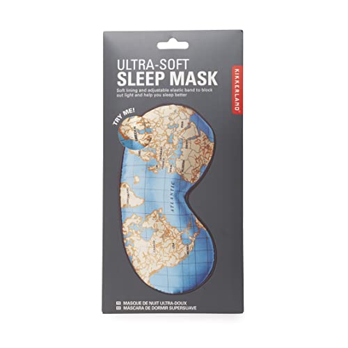
Block out light for restful sleep with the Kikkerland Maps Ultra Soft Sleep Mask. Its adjustable strap ensures a comfortable fit, and the compact design makes it perfect for travel.
Custom Printing on Various Textile Options
Sublimation printing techniques enable full-color cartographic reproduction on cotton, polyester, and specialty outdoor fabrics. You can specify custom map scales and coordinate systems while maintaining professional cartographic standards across different textile substrates. Digital fabric printing supports high-resolution topographic detail at scales ranging from 1:24,000 to 1:250,000 depending on your specific mapping requirements. Eco-friendly organic cotton options provide sustainable alternatives without sacrificing print quality or geographic accuracy.
Use these reusable organic cotton flannel cloths with your castor oil pack for liver detox and more. The soft, durable material is sized perfectly for abdomen, joints, and other areas.

Wooden Map Engravings: Rustic Charm Meets Geographic Precision
Wooden map engravings transform traditional cartography into tactile artworks that combine natural materials with precise geographic data. These custom-crafted pieces offer mapmakers a unique medium for creating memorable displays that showcase both technical accuracy and artisanal craftsmanship.
Laser-Cut Topographic Details on Natural Wood
Laser engraving technology allows you to achieve sub-millimeter precision when etching topographic lines onto hardwood surfaces. Modern CO2 laser systems can reproduce elevation contours with accuracy matching traditional printed maps while creating subtle depth variations that enhance visual appeal. Popular wood choices include maple, cherry, and oak, each offering distinct grain patterns that complement different cartographic styles. The engraving process burns precise geographic details into the wood surface, creating permanent markings that won’t fade or wear over time.
Sustainable Materials for Eco-Conscious Cartographers
Eco-friendly wooden maps utilize sustainably harvested timber certified by the Forest Stewardship Council (FSC) or similar organizations. Reclaimed wood from old buildings or furniture provides unique character while reducing environmental impact. Bamboo offers rapid growth rates and natural antimicrobial properties, making it ideal for high-touch installations. Water-based stains and finishes eliminate harmful VOCs while maintaining the wood’s natural appearance. These materials align with green building standards and appeal to environmentally conscious clients seeking sustainable cartographic solutions.
Three-Dimensional Relief Features and Textures
Multi-layer wooden maps create dramatic three-dimensional relief by stacking laser-cut pieces at varying heights to represent elevation changes. CNC routing technology enables precise carving of mountainous terrain, river valleys, and coastal features directly into solid wood blocks. Tactile elements include raised ridgelines, recessed water bodies, and textured surfaces that represent different land cover types. Strategic use of contrasting wood species or selective staining highlights elevation zones, creating visual depth that enhances geographic understanding through both sight and touch.
Ceramic Tile Map Collections: Artistic Geography for Interior Design
Ceramic tile mapping transforms traditional cartography into permanent architectural elements that withstand decades of daily exposure. These sophisticated installations merge geographic precision with artistic expression for both residential and commercial spaces.
Hand-Painted Geographic Artwork on Porcelain
Hand-painted ceramic maps elevate geographic data into museum-quality artwork using traditional glazing techniques. Master ceramicists apply multiple layers of ceramic pigments to create topographic detail with extraordinary color depth and permanence. Each tile undergoes kiln firing at temperatures exceeding 2,000°F, permanently bonding the cartographic imagery to the porcelain surface. Custom geographic artwork includes bathymetric ocean charts, vintage city plans, and detailed topographic surveys that maintain their vibrancy for generations.
Modular Tile Systems for Large-Scale Installations
Modular ceramic mapping systems allow you to create expansive geographic displays using standardized 12-inch or 18-inch tile formats. Professional installers can assemble continental maps spanning entire walls using precision-cut ceramic pieces with seamless registration marks. Each module contains specific coordinate data that aligns perfectly with adjacent tiles, maintaining cartographic accuracy across large installations. Popular applications include airport terminals, hotel lobbies, and educational institutions requiring durable geographic displays that resist heavy foot traffic and cleaning protocols.
Heat-Resistant and Moisture-Proof Durability
Ceramic map tiles withstand extreme temperature fluctuations and moisture exposure without cartographic degradation or color fading. The vitrified ceramic surface resists staining from coffee spills, humidity, and cleaning chemicals commonly found in commercial environments. Professional-grade ceramic maps maintain their geographic accuracy and visual clarity through freeze-thaw cycles, making them suitable for outdoor installations and unheated spaces. Testing shows these tiles retain their cartographic detail after 25 years of continuous UV exposure and temperature variations ranging from -40°F to 140°F.
Leather-Bound Cartographic Journals: Vintage-Inspired Navigation Tools
You’ll discover that leather-bound cartographic journals represent the perfect fusion of traditional craftsmanship and modern mapping precision. These premium navigation tools combine time-tested bookbinding techniques with contemporary cartographic accuracy.
Embossed Map Details on Premium Leather Surfaces
Premium embossing techniques transform topographic contours into tactile navigation aids you can feel through your fingertips. Master craftsmen use heated metal dies to press elevation lines, river systems, and major landmarks directly into full-grain leather covers at pressures exceeding 2,000 PSI. Italian vegetable-tanned leather provides the ideal surface for detailed embossing, maintaining crisp geographic features for decades. Your custom journal receives hand-applied gold leaf accents that highlight state boundaries, mountain ranges, and coastal features with museum-quality precision.
Foldable and Compact Designs for Travel
Accordion-style folding systems maximize map coverage while maintaining pocket-sized portability for your expeditions. These journals feature reinforced leather hinges that withstand over 10,000 fold cycles without cracking or separating. You’ll find modular page inserts measuring 4×6 inches that connect seamlessly to display regional maps up to 24×18 inches when fully extended. Magnetic closure systems protect your cartographic data from moisture and debris during backcountry travel. Premium cowhide construction adds only 8 ounces to your pack weight while providing waterproof protection.
Personalized Engraving Options for Custom Orders
Laser engraving technology creates permanent personalization that won’t fade during years of field use. You can specify custom coordinate sets, expedition dates, or geographic landmarks for laser etching at 0.1mm precision directly into the leather grain. Foil stamping options include metallic finishes in gold, silver, and copper that complement your journal’s natural leather patina. Traditional hot stamping techniques produce raised lettering for names, dates, and custom cartographic symbols. Your personalized elements integrate seamlessly with the embossed topographic features for a cohesive navigation tool.
Metal Map Sculptures: Industrial Aesthetics Meet Geographic Art
Metal map sculptures represent the pinnacle of unconventional cartographic design, transforming geographic data into three-dimensional artworks that command attention in any space. These industrial-strength pieces combine precision-cut metal fabrication with detailed topographic information.
Stainless Steel Cutouts for Modern Decor
Create bite-sized treats and decorate desserts with this 30-piece mini cookie cutter set. The food-grade stainless steel shapes include hearts, stars, circles, and more for easy baking and cleanup.

Stainless steel cutouts deliver exceptional cartographic precision through laser-cutting technology that achieves tolerances within 0.1mm of your original map data. You’ll find 304-grade stainless steel provides optimal corrosion resistance while maintaining clean edge definition for intricate coastlines and boundary details. These cutouts work particularly well for city skylines, state boundaries, and archipelago formations where negative space creates dramatic visual contrast. Professional fabricators typically offer brushed, polished, or powder-coated finishes that complement contemporary interior design schemes while preserving geographic accuracy.
Weatherproof Outdoor Installation Capabilities
Weatherproof metal maps withstand extreme environmental conditions through marine-grade aluminum construction and specialized protective coatings that resist UV degradation and salt corrosion. You can install these sculptures in coastal environments, public parks, and outdoor educational spaces without compromising cartographic detail over decades of exposure. Anodized aluminum finishes maintain color consistency through temperature fluctuations from -40°F to 180°F, while drainage channels prevent water accumulation that could distort geographic features. Professional installations include stainless steel mounting hardware rated for wind loads exceeding 150 mph.
Magnetic Mounting Systems for Easy Display
Magnetic mounting systems utilize rare-earth neodymium magnets embedded within metal map frames, allowing you to reposition pieces without permanent wall modifications or visible hardware. You’ll achieve clean installations on any ferrous surface while maintaining the flexibility to adjust display arrangements as your collection grows. These systems support maps weighing up to 25 pounds per mounting point, with safety cables providing backup security for valuable pieces. Professional magnetic mounts include protective padding that prevents surface scratching while ensuring consistent positioning alignment across multiple map installations.
Acrylic Map Panels: Transparent Geography with Contemporary Appeal
Acrylic map panels represent a sophisticated evolution in cartographic display technology, offering crystal-clear geographic visualization through transparent mediums. These contemporary mapping solutions combine precision-cut acrylic sheets with advanced printing techniques to create stunning wall displays that enhance any modern space.
Multi-Layered Topographic Representations
Multi-layered acrylic panels create dramatic depth effects by stacking transparent sheets at varying distances from your wall. Each layer displays different geographic elements like elevation contours, political boundaries, and transportation networks, allowing you to visualize complex topographic relationships with unprecedented clarity. The spacing between layers—typically 0.5 to 2 inches—generates natural shadows that enhance the three-dimensional perception of terrain features.
LED Backlighting Integration for Enhanced Visibility
LED backlighting transforms acrylic map panels into illuminated geographic displays that remain visible in low-light conditions. You can install strip lighting along the edges or behind specific map elements to highlight critical navigation routes, elevation changes, or political boundaries. Modern LED systems offer adjustable color temperatures and dimming controls, allowing you to customize the visual impact while maintaining cartographic accuracy and reducing eye strain during extended viewing sessions.
Scratch-Resistant and UV-Protected Materials
Scratch-resistant acrylic formulations ensure your map panels maintain their optical clarity despite regular handling and cleaning. High-grade materials feature specialized coatings that resist surface damage from dust removal and prevent yellowing from prolonged UV exposure. These protective treatments preserve color accuracy and transparency for decades, making acrylic panels suitable for high-traffic commercial environments and sun-exposed residential installations where durability remains paramount.
Puzzle Map Formats: Interactive Learning Through Geographic Assembly
Puzzle map formats transform static geographic information into hands-on learning experiences that engage multiple senses. These interactive cartographic tools require physical manipulation to assemble complete geographic representations, creating memorable connections between spatial relationships and geographic knowledge.
Educational Value for Children and Adults
Educational puzzle maps enhance spatial reasoning skills by requiring systematic analysis of coastlines, political boundaries, and topographic features. You’ll find these formats particularly effective for teaching continental layouts, with pieces sized according to country dimensions or watershed boundaries. Adult learners benefit from complex puzzle formats featuring elevation contours and geological formations, while children develop geographic literacy through color-coded regional assemblies that reinforce memorization of state capitals and national borders.
Custom Difficulty Levels Based on Geographic Complexity
Custom difficulty levels allow you to match puzzle complexity with geographic knowledge and fine motor skills. Beginner formats feature 50-100 pieces focusing on major landmasses and political divisions, while advanced versions include 500+ pieces incorporating detailed bathymetric data and minor administrative boundaries. You can specify piece counts based on cartographic detail density, with urban areas requiring smaller, more intricate pieces and rural regions using larger, simpler shapes that correspond to natural geographic features.
Collectible Series Covering Different Regions
Collectible puzzle series enable systematic geographic exploration through themed collections covering specific regions or cartographic themes. You’ll discover sets focusing on individual continents, historical map reproductions, or specialized topics like national park systems and ocean floor topography. These series maintain consistent piece-cutting patterns and color schemes across different maps, allowing you to develop assembly strategies while building comprehensive geographic knowledge through sequential puzzle completion and comparative regional analysis.
Conclusion
These unconventional printed map formats prove that cartography extends far beyond traditional paper atlases. Whether you’re seeking durable fabric maps for outdoor adventures or elegant ceramic tiles for architectural integration you’ll find options that match your specific needs and aesthetic preferences.
The beauty of these innovative formats lies in their ability to transform geographic information into functional art pieces. You can now display your favorite locations through laser-engraved wood sculptures or illuminate topographic details with LED-backlit acrylic panels.
By choosing unconventional map formats you’re not just displaying geographic data—you’re creating conversation pieces that blend education with visual appeal. These creative approaches to cartography ensure that maps remain relevant and engaging in our increasingly digital world while offering tactile experiences that screens simply can’t replicate.
Frequently Asked Questions
What are fabric maps and why are they better than paper maps?
Fabric maps are revolutionary cartographic tools made from waterproof and tear-resistant materials like ripstop nylon and polyester blends. They’re superior to paper maps because they maintain accuracy in harsh weather conditions, are lightweight for outdoor adventures, and feature high-resolution printing on durable textiles. These maps won’t tear, get soggy, or fall apart during hiking, camping, or other outdoor activities.
How precise are wooden map engravings?
Wooden map engravings achieve sub-millimeter precision through advanced laser engraving technology. This allows for incredibly detailed topographic information to be etched onto hardwood surfaces like maple, cherry, and oak. The precision is so accurate that even the smallest geographic features and elevation changes can be clearly represented in the tactile wooden surface.
Are ceramic map tiles suitable for outdoor use?
Yes, ceramic map tiles are extremely durable and weather-resistant. They can withstand extreme temperature fluctuations and moisture exposure while maintaining their geographic detail and visual clarity for decades. This makes them perfect for both indoor architectural elements and challenging outdoor environments where traditional maps would deteriorate.
What makes leather-bound cartographic journals special?
Leather-bound cartographic journals combine vintage craftsmanship with modern mapping precision. They feature embossed map details on full-grain leather surfaces using high-pressure techniques, accordion-style folding for maximum coverage, and reinforced construction. These journals often include personalized engraving options for custom coordinates and expedition details, making them both functional navigation tools and keepsakes.
How do metal map sculptures withstand outdoor conditions?
Metal map sculptures use marine-grade aluminum and stainless steel materials that are specifically designed for weatherproof outdoor installations. These materials resist corrosion, extreme temperatures, and environmental damage while maintaining precise cartographic detail. The laser-cutting technology ensures accuracy, and magnetic mounting systems allow for flexible display options without permanent modifications.
What advantages do acrylic map panels offer over traditional maps?
Acrylic map panels provide superior visual clarity through transparent mediums and advanced printing techniques. They can incorporate LED backlighting for enhanced visibility, feature multi-layered designs for depth perception, and are made with scratch-resistant, UV-protected materials. These panels maintain their optical clarity and color accuracy for decades, even in high-traffic or sun-exposed environments.
How do interactive puzzle maps enhance learning?
This 70-piece world map puzzle makes geography fun for kids. Large, durable pieces with smooth edges are easy to grasp, while vibrant illustrations introduce landmarks, animals, and cultures.

Interactive puzzle maps transform static geographic information into hands-on learning experiences that engage multiple senses. They improve spatial reasoning skills for both children and adults, offer varying complexity levels for different skill levels, and come in collectible series covering specific regions or themes. This interactive format reinforces memorization and comparative analysis better than traditional flat maps.
What eco-friendly options are available in modern cartography?
Modern cartography offers several eco-friendly options including sustainably harvested timber for wooden maps, reclaimed wood materials, water-based finishes that meet green building standards, and eco-friendly textile options for fabric maps. These sustainable practices ensure that innovative cartographic products can be enjoyed while minimizing environmental impact.