5 Methods for Remote Area Accessibility Mapping That Unlock Spatial Data
Why it matters: Remote area accessibility mapping has become critical for emergency response disaster relief and infrastructure planning as climate change increases extreme weather events worldwide.
The challenge: Traditional mapping methods fail in areas with limited road access poor internet connectivity and harsh terrain conditions that affect millions of people globally.
What’s ahead: Five proven mapping techniques can help organizations governments and researchers accurately assess and document accessibility in the world’s most isolated regions.
Disclosure: As an Amazon Associate, this site earns from qualifying purchases. Thank you!
P.S. check out Udemy’s GIS, Mapping & Remote Sensing courses on sale here…
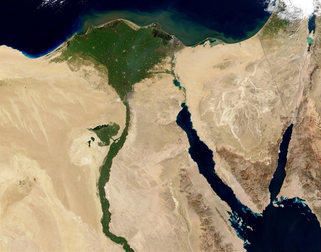
Satellite Imagery Analysis for Remote Terrain Assessment
Satellite imagery analysis transforms your ability to map inaccessible terrain by providing comprehensive visual data from space-based sensors. This method delivers critical information about remote areas without requiring physical presence or ground-based equipment.
High-Resolution Satellite Data Collection
You’ll achieve optimal results using commercial satellites like WorldView-3 or GeoEye-1 that capture imagery at 0.3-0.5 meter resolution. These platforms provide multispectral bands including near-infrared and shortwave infrared that reveal terrain features invisible to standard photography. Schedule acquisitions during optimal weather conditions and consider seasonal variations that affect visibility. Government sources like Landsat 8 offer free alternatives at 15-30 meter resolution for broader area coverage.
Digital Elevation Model Creation
You can generate accurate elevation models using stereo satellite pairs or interferometric synthetic aperture radar (InSAR) data. ASTER Global DEM provides free 30-meter resolution elevation data covering most remote areas worldwide. Advanced processing techniques like photogrammetry from overlapping satellite images create higher resolution DEMs at 5-10 meter accuracy. Validate elevation models against known ground control points when available to ensure terrain assessment reliability.
Land Cover Classification Techniques
You’ll classify terrain features using supervised classification algorithms that identify vegetation types, water bodies, and infrastructure from spectral signatures. Machine learning approaches like Random Forest or Support Vector Machines process multispectral data to distinguish between forest canopy, grasslands, rocky terrain, and human-made structures. Combine classification results with terrain slope analysis to identify potential access routes and mobility constraints across different landscape types.
GPS-Based Field Surveying in Challenging Environments
GPS field surveying remains your most reliable method for ground-truthing satellite-derived accessibility data in remote areas. This technique provides precise coordinate verification and captures real-time conditions that satellite imagery can’t detect.
Handheld GPS Device Deployment
Navigate with ease using this 7-inch GPS navigator, featuring real-time voice guidance and pre-loaded 2025 maps. Customize routes based on your vehicle type to avoid restrictions and receive speed & red light warnings.

Select ruggedized GPS units designed for extreme environments like the Garmin GPSMAP 66i or Trimble Geo 7X. These devices maintain accuracy within 3-5 meters in challenging terrain including dense forest canopy and steep mountain slopes. Configure your units for the local coordinate system before deployment and carry backup batteries for extended field operations. Test signal acquisition in similar terrain conditions to verify performance expectations before beginning your survey work.
Stay connected anywhere with this compact satellite communicator. Enjoy two-way messaging, interactive SOS, and TracBack routing for confident navigation. Battery lasts up to 14 days in tracking mode.

Ground Truth Data Collection Methods
Document accessibility barriers systematically using standardized field forms that record GPS coordinates alongside obstacle descriptions. Photograph each surveyed point with your device’s built-in camera to create geotagged visual references. Record elevation changes, surface conditions, and seasonal access limitations at 100-meter intervals along potential routes. Your field teams should measure road widths, bridge capacities, and gradient percentages to validate satellite-based terrain analysis and identify mobility constraints.
Coordinate System Standardization
Establish consistent datum reference using WGS84 or your region’s official coordinate system like NAD83 for North American projects. Configure all GPS devices to output coordinates in the same format whether decimal degrees or UTM zones to prevent georeferencing errors. Create conversion protocols for integrating field GPS data with existing GIS databases and satellite imagery layers. Document your chosen coordinate system parameters in metadata files to ensure long-term data compatibility and accurate spatial analysis.
Drone Technology for Aerial Mapping Solutions
Learn the science behind unmanned flight and UAV systems. This guide offers a step-by-step approach to understanding drone and UAV technology engineering.

Drone technology revolutionizes remote area accessibility mapping by providing high-resolution imagery and real-time data collection capabilities that complement satellite analysis methods. UAVs eliminate the need for physical ground access while delivering precision mapping data at significantly lower costs than traditional aircraft surveys.
UAV Flight Path Planning
Optimize your drone missions using automated flight path planning software like DroneDeploy or Pix4Dcapture to ensure complete coverage of remote terrain. You’ll need to calculate overlap percentages of 70-80% frontlap and 60-70% sidelap for accurate photogrammetric processing. Plan flight altitudes between 150-400 feet above ground level to balance image resolution with battery life constraints. Consider wind patterns and terrain elevation changes when programming waypoints to maintain consistent ground sampling distance across varied topography.
Real-Time Data Transmission Capabilities
Establish reliable data transmission systems using long-range radio links or cellular modules to stream mapping data during flight operations. You can implement LTE or 4G connectivity modules on drones like the DJI Matrice 300 RTK for real-time image transmission up to 15 kilometers from base stations. Configure ground control stations with high-gain antennas to extend communication range in mountainous terrain. Real-time transmission enables immediate route adjustments and ensures data collection continues even if GPS positioning becomes compromised during extended missions.
Capture stunning visuals with the DJI Mavic 3 Pro Cine. This flagship drone features a triple-camera system with Apple ProRes support and a high-bright DJI RC Pro screen for professional-grade control and clarity. Enjoy extended flight times and omnidirectional obstacle sensing for safe, confident flying.

3D Topographic Model Generation
Generate detailed digital surface models using photogrammetric processing software such as Agisoft Metashape or Pix4Dmapper to create accurate elevation datasets from drone imagery. You’ll achieve ground sampling distances of 2-5 centimeters per pixel depending on flight altitude and camera specifications. Process overlapping images through structure-from-motion algorithms to produce point clouds containing millions of elevation points. Export finished models as GeoTIFF files compatible with GIS software for accessibility analysis and route planning applications.
Geographic Information Systems (GIS) Integration
GIS integration transforms isolated mapping efforts into comprehensive accessibility analysis platforms. You’ll combine multiple data sources and analytical tools to create robust remote area mapping solutions.
Multi-Layer Data Compilation
Layer compilation requires you to standardize coordinate systems and datum references across all data sources before analysis begins. You’ll typically work with elevation models from satellite stereo pairs, road network vectors from OpenStreetMap, and land cover classifications from Landsat or Sentinel imagery. Import GPS survey points as verification layers and drone-derived orthomosaics as high-resolution base maps. Store compiled datasets in geodatabase formats like File GDB or PostGIS to maintain spatial relationships and attribute linkages throughout your accessibility mapping workflow.
Spatial Analysis Tools Implementation
Spatial analysis tools enable you to calculate least-cost paths and accessibility indices using weighted distance algorithms in ArcGIS Network Analyst or QGIS processing toolbox. You’ll apply slope analysis functions to identify terrain constraints and buffer operations to determine proximity to transportation infrastructure. Use viewshed analysis to assess visibility from potential access points and watershed delineation to understand drainage patterns affecting route viability. Implement cost-distance modeling with impedance values based on terrain difficulty, vegetation density, and seasonal accessibility factors for comprehensive route planning.
Interactive Map Visualization
Interactive visualization transforms your GIS analysis into accessible web-based mapping applications using platforms like ArcGIS Online, Mapbox, or Leaflet JavaScript libraries. You’ll create dynamic symbology that adjusts based on zoom levels and user-selected accessibility criteria. Implement pop-up windows displaying attribute information, geotagged photographs, and real-time condition updates from field surveys. Configure layer toggles allowing users to compare different accessibility scenarios and time periods. Deploy responsive design elements ensuring your maps function effectively across desktop and mobile devices for field reference applications.
Community-Based Participatory Mapping Approaches
Community-based participatory mapping harnesses local expertise to create comprehensive accessibility assessments that traditional remote sensing often misses. This approach transforms residents into skilled data collectors who understand their terrain’s seasonal variations and cultural significance.
Local Knowledge Documentation
Document local route knowledge through structured interviews with community elders and frequent travelers who possess decades of navigational experience. Create systematic recording protocols using digital audio devices like Zoom H1n Handy Recorders paired with GPS units to capture precise location references during storytelling sessions. Establish standardized data collection forms that capture seasonal accessibility patterns, traditional pathway names, and cultural restrictions that affect route selection in remote areas.
Capture pristine audio effortlessly with the Zoom H1essential. This portable recorder features 32-bit float recording, eliminating gain adjustments, and high-quality X/Y microphones for clear sound up to 120 dB SPL.

Collaborative Data Collection Training
Train community members in basic GPS operation and smartphone mapping applications like KoBoToolbox or Survey123 to ensure consistent data quality across multiple collectors. Develop simplified data collection protocols that focus on essential accessibility metrics including pathway width measurements, surface conditions, and obstacle documentation using standardized photography techniques. Implement quality control workshops where participants practice coordinate capture and learn to identify common GPS accuracy issues in challenging terrain environments.
Experience vivid content on the Galaxy A16 5G's 6.7" display and capture stunning photos with its triple-lens camera. Enjoy peace of mind with a durable design, six years of updates, and Super Fast Charging.

Indigenous Navigation System Integration
Integrate traditional navigation markers such as seasonal water sources, landmark rocks, and vegetation patterns into digital mapping frameworks using culturally appropriate symbology and naming conventions. Combine indigenous route knowledge with modern GPS coordinates to create hybrid navigation systems that respect traditional pathways while providing accurate spatial references for emergency response planning. Document traditional distance measurements and time estimates alongside metric measurements to preserve cultural navigation methods within accessibility databases.
Conclusion
These five mapping methods give you powerful tools to assess accessibility in the world’s most challenging terrains. By combining satellite technology with ground-based surveys you’ll create more accurate and comprehensive datasets than any single approach could provide.
The key to success lies in selecting the right combination of techniques for your specific project needs. Whether you’re planning emergency response routes or developing infrastructure projects your choice should align with available resources and required accuracy levels.
Remember that community involvement strengthens every mapping initiative. Local knowledge fills gaps that even the most advanced technology can’t capture making your accessibility assessments more reliable and culturally appropriate.
As remote area mapping technology continues advancing you’ll find new opportunities to reach previously unmappable regions. Start implementing these methods today to build the foundation for more effective accessibility planning in isolated communities worldwide.
Frequently Asked Questions
What is remote area accessibility mapping and why is it important?
Remote area accessibility mapping is the process of documenting and analyzing transportation routes, terrain conditions, and access points in isolated regions. It’s crucial for emergency response, disaster relief, and infrastructure planning, especially as climate change increases extreme weather events. This mapping helps organizations and governments understand how to reach vulnerable populations and plan effective interventions in areas with limited road access and challenging terrain.
What are the main challenges in mapping remote areas?
The primary challenges include limited road access, poor internet connectivity, difficult terrain, and lack of ground-based infrastructure. Traditional mapping methods often fail in these regions, leaving millions of people in unmapped areas. Weather conditions, security concerns, and the high cost of ground surveys also complicate accessibility mapping efforts in remote locations.
How does satellite imagery help in remote area mapping?
Satellite imagery provides detailed visual information without requiring physical presence in remote areas. High-resolution satellites like WorldView-3 and GeoEye-1 offer precise terrain analysis, enabling the creation of digital elevation models and land cover classification. Machine learning algorithms can identify terrain features and potential access routes, making satellite imagery a cost-effective solution for initial accessibility assessments.
What role do drones play in accessibility mapping?
Drones revolutionize aerial mapping by providing high-resolution imagery and real-time data collection that complements satellite analysis. UAVs can capture detailed photographs at lower altitudes, create accurate digital surface models through photogrammetric processing, and enable immediate route adjustments through real-time image streaming. They’re particularly valuable for mapping smaller areas with greater detail than satellites can provide.
How do GPS-based field surveys contribute to remote mapping?
GPS field surveys provide ground-truthing for satellite-derived data, using ruggedized devices like Garmin GPSMAP 66i or Trimble Geo 7X for accurate coordinate verification. Field teams document accessibility barriers, measure road conditions, and capture geotagged photographs. This method validates satellite analyses and ensures mapping accuracy by providing real-world verification of remote terrain conditions.
What is the importance of GIS in accessibility mapping?
Geographic Information Systems (GIS) integrate various data sources into comprehensive accessibility analysis platforms. GIS enables multi-layer data compilation, spatial analysis for calculating least-cost paths, and creation of interactive web-based mapping applications. It standardizes coordinate systems across different data sources and provides tools for dynamic accessibility scenario modeling and real-time field survey updates.
How does community-based participatory mapping work?
Community-based participatory mapping leverages local expertise to document accessibility routes often missed by remote sensing. It involves structured interviews with community elders and frequent travelers, training locals in GPS operation and smartphone mapping applications, and integrating traditional navigation markers into digital frameworks. This approach respects cultural significance while enhancing emergency response planning through indigenous knowledge.
What equipment is recommended for remote area mapping?
Essential equipment includes ruggedized GPS devices (Garmin GPSMAP 66i, Trimble Geo 7X), high-resolution drones with photogrammetric capabilities, digital audio recording devices for community interviews, and smartphones with mapping applications. Satellite imagery subscriptions and GIS software are also crucial for data analysis and visualization.