7 Best Drone Map Enhancements for Professionals
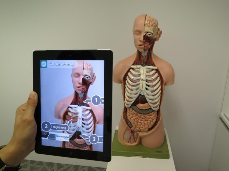
You’re looking at the future of spatial data visualization where drone mapping meets augmented reality technology. Traditional drone maps provide valuable aerial insights but AR integration transforms static imagery into interactive 3D experiences that overlay real-world environments with digital information layers.
This powerful combination lets you visualize complex datasets in ways that were impossible just a few years ago. Whether you’re managing construction projects surveying agricultural land or conducting environmental assessments AR-enhanced drone maps deliver actionable intelligence through immersive visual experiences that improve decision-making and operational efficiency.
Disclosure: As an Amazon Associate, this site earns from qualifying purchases. Thank you!
Understanding the Fundamentals of Drone Mapping and Augmented Reality Integration
The technical foundation for AR-enhanced drone mapping requires understanding how these two technologies complement each other’s capabilities.
P.S. check out Udemy’s GIS, Mapping & Remote Sensing courses on sale here…
Achieve a flawless, even complexion with e.l.f. Flawless Satin Foundation. This lightweight, vegan formula provides medium coverage and a semi-matte finish for all-day wear, while hydrating your skin with glycerin.

What Is Drone Mapping Technology
Drone mapping technology captures aerial imagery and sensor data to create accurate two-dimensional orthomosaics and three-dimensional point clouds. Modern mapping drones like the DJI Phantom 4 RTK use GPS coordinates and photogrammetry algorithms to generate precise spatial datasets with centimeter-level accuracy. You’ll find these systems particularly effective for surveying large areas quickly while maintaining consistent ground sample distances across your project site. Professional mapping software such as Pix4D and Agisoft Metashape processes the captured imagery into georeferenced maps suitable for integration with AR platforms.
Replace your damaged Phantom 4 Pro V2.0 drone body with this new aircraft, which includes a gimbal camera and carry case. Compatible with GL300L and GL300K remotes only; excludes battery, charger, propellers, and other accessories.

How Augmented Reality Transforms Spatial Data
Augmented reality technology overlays digital information onto real-world environments through specialized viewing devices or mobile applications. When you integrate drone-captured spatial data with AR systems you create immersive visualizations that display hidden infrastructure utilities or proposed construction elements directly on-site. AR platforms like ARCore and ARKit use device cameras and sensors to anchor virtual objects to precise geographic coordinates from your drone surveys. This transformation allows you to visualize subsurface features elevation changes and planned modifications within their actual physical context.
Benefits of Combining Drone Maps with AR
Enhanced visualization capabilities emerge when you combine high-resolution drone imagery with AR’s interactive display features. You’ll reduce project communication errors by up to 40% when stakeholders can view proposed changes overlaid on actual terrain through AR interfaces. Field teams experience improved decision-making speed since they can access real-time data visualization without returning to desktop workstations. Cost savings of 15-25% typically result from reduced site visits and faster problem identification when using AR-enhanced drone maps for project management tasks.
Stay organized with this 48-inch workbench featuring drawers, shelves, and a pegboard. The enamel-coated work surface supports up to 220 pounds and includes built-in power outlets and a fluorescent light.
Selecting the Right Hardware for AR-Enhanced Drone Mapping
The success of your AR-enhanced drone mapping projects depends heavily on hardware compatibility and performance specifications. Your equipment selection directly impacts data quality, processing speed, and the overall user experience of your augmented reality overlays.
Choosing Compatible Drone Models
Professional-grade drones with RTK capabilities provide the precision necessary for accurate AR alignment. The DJI Phantom 4 RTK delivers centimeter-level accuracy essential for georeferenced AR overlays. Enterprise models like the DJI Matrice 300 RTK offer superior payload capacity for multiple sensors and extended flight times up to 55 minutes. Fixed-wing drones such as the senseFly eBee X excel in large-area mapping projects requiring consistent altitude and speed. Your drone choice should support programmable flight paths and maintain stable GPS connections throughout data collection missions.
Essential AR Headsets and Mobile Devices
Experience immersive entertainment with the VITURE Pro XR Glasses, featuring a vibrant 135" virtual display with 120Hz refresh rate and built-in myopia adjustments for comfortable viewing. Enjoy enhanced privacy with electrochromic film that blocks nearly all external light and crystal-clear audio via Harman-engineered sound.

High-performance AR devices handle complex 3D rendering and real-time data processing requirements. Microsoft HoloLens 2 provides untethered operation with 6DOF tracking for professional fieldwork applications. Magic Leap 2 offers superior visual clarity with 2K per eye resolution for detailed infrastructure visualization. Mobile devices like iPad Pro models with LiDAR sensors enable cost-effective AR experiences through apps like DroneDeploy Live Map. Android tablets with ARCore support provide broader hardware compatibility options. Your device selection should prioritize processing power, battery life exceeding 4 hours, and weather resistance ratings appropriate for outdoor mapping conditions.
Get a comfortable and hygienic HoloLens 2 experience with this 10-pack of brow pads. Designed for easy replacement, these pads ensure optimal fit and cleanliness during extended use.

Camera and Sensor Requirements
Multi-spectral imaging capabilities expand your AR visualization options beyond standard RGB photography. High-resolution cameras with 20MP+ sensors capture detailed texture mapping essential for realistic AR overlays. Thermal imaging sensors like FLIR Vue TZ20 reveal infrastructure conditions invisible to standard cameras. LiDAR sensors provide precise elevation data for accurate 3D model generation and AR registration. IMU sensors with 9-axis stabilization ensure consistent image quality during flight operations. Your sensor package should include GPS/GNSS receivers with sub-meter accuracy and synchronized timestamping for proper data georeferencing across all captured datasets.
Capture stunning photos and videos with this 4K 64MP digital camera. Features include a 180° flip screen for easy vlogging and built-in WiFi for seamless sharing.

Installing and Configuring AR Mapping Software Solutions
Setting up AR mapping software requires careful attention to compatibility requirements and calibration procedures. You’ll need to configure multiple software components to work seamlessly with your drone data and AR hardware.
Popular AR Mapping Applications
Pix4D offers comprehensive AR visualization tools with drone integration capabilities for construction and surveying projects. ArcGIS Field Maps provides enterprise-level AR functionality with advanced 3D rendering and real-time collaboration features. DroneDeploy includes AR overlay features that work directly with DJI drones and mobile devices. Bentley LumenRT delivers professional-grade AR visualization for infrastructure projects with precise georeferencing capabilities.
Software Compatibility Requirements
Your AR mapping software must support OpenGL 3.0 or higher for proper 3D rendering performance. Operating systems need iOS 12+ or Android 8.0+ with minimum 4GB RAM for mobile AR applications. Desktop solutions require Windows 10 Pro or macOS 10.15+ with dedicated graphics cards supporting DirectX 11. Ensure your software accepts GeoTIFF and LAZ file formats from your drone mapping workflow for seamless data integration.
Initial Setup and Calibration Process
Download and install your chosen AR software following manufacturer specifications for your hardware configuration. Import your drone orthomosaics and point cloud data using the software’s data management tools. Configure coordinate systems to match your project’s local projection and datum requirements. Calibrate AR tracking by establishing ground control points and testing overlay accuracy in your mapping area before field deployment.
Capturing High-Quality Drone Data for AR Enhancement
Quality drone data forms the foundation for successful AR visualization projects. Your data capture strategy directly impacts AR tracking accuracy and user experience quality.
Optimal Flight Planning Techniques
Plan flight paths with 80-85% forward overlap and 70-75% side overlap to ensure complete coverage for AR reconstruction. Set your flight altitude between 200-400 feet AGL depending on ground sample distance requirements. Execute double-grid patterns at perpendicular angles to capture nadir and oblique imagery for better 3D model generation. Configure automated waypoint missions using DroneDeploy or Pix4Dcapture to maintain consistent speed and eliminate pilot error during critical data collection phases.
Image Resolution and Overlap Standards
Maintain ground sample distance between 1-3 cm/pixel for AR applications requiring precise object recognition and tracking. Capture images in RAW format when possible to preserve maximum detail for post-processing workflows. Use consistent camera settings throughout flight missions including fixed ISO, shutter speed, and aperture to ensure uniform lighting and exposure. Set your drone’s gimbal to -90 degrees for nadir shots and include 15-20% oblique images at -60 degrees for enhanced 3D reconstruction quality.
GPS and Georeferencing Best Practices
Establish ground control points every 500-1000 meters across your survey area using high-precision GPS equipment for sub-centimeter accuracy. Record GCP coordinates in the same coordinate system your AR software will use to minimize transformation errors. Verify GPS signal quality before takeoff ensuring 12+ satellite connections and HDOP values below 2.0 for reliable positioning data. Process your drone imagery using PPK or RTK corrections when available to achieve the 2-5 cm accuracy required for stable AR tracking performance.
Processing and Preparing Drone Maps for AR Integration
After capturing high-quality drone data, you’ll need to process and prepare your aerial imagery for seamless AR integration. This preparation phase transforms raw drone images into optimized 3D models that deliver smooth augmented reality experiences.
Data Processing Workflow Steps
Process your drone images using photogrammetry software like Pix4D or Agisoft Metashape. Import your RAW images and verify GPS coordinates match your ground control points. Execute automatic tie point detection to identify common features across overlapping images. Generate dense point clouds with medium to high quality settings for AR applications. Create orthomosaic maps at 2-5 cm resolution for optimal AR tracking performance. Export your processed data in multiple formats to ensure compatibility with AR platforms.
Creating 3D Models from Drone Images
Generate textured 3D meshes from your processed point clouds using software like Reality Capture or 3DF Zephyr. Set mesh resolution to 200,000-500,000 vertices for mobile AR applications to maintain performance. Apply texture mapping with 4K resolution images for visual clarity in AR environments. Optimize your 3D models by reducing polygon count while preserving geometric accuracy. Export models in OBJ or FBX formats with embedded textures for direct AR platform integration.
Optimizing File Formats for AR Applications
Convert your 3D models to AR-compatible formats like USDZ for iOS or GLB for Android platforms. Compress texture files to 1024×1024 pixels maximum to ensure smooth AR rendering on mobile devices. Use LOD (Level of Detail) techniques to create multiple model versions at different resolutions. Implement mesh decimation to reduce file sizes by 60-80% while maintaining visual quality. Store your optimized models in cloud storage services like AWS S3 for real-time AR streaming capabilities.
Implementing Real-Time AR Overlays on Drone Maps
Once you’ve prepared your drone maps for AR integration, you’ll need to implement dynamic overlay systems that respond to live conditions and user interactions.
Adding Interactive Digital Elements
Interactive elements transform static drone maps into dynamic AR experiences that respond to user gestures and environmental changes. You’ll integrate clickable 3D objects like building models and infrastructure components using Unity’s XR Interaction Toolkit or ARCore’s Anchoring API. These elements should include tap-to-reveal information windows, distance measurement tools, and draggable waypoint markers that update coordinates in real-time. Popular implementations include progress tracking overlays for construction projects and equipment status indicators for industrial inspections.
Incorporating Live Data Feeds
Live data feeds enhance AR drone maps by streaming real-time information from IoT sensors, weather stations, and project management systems. You’ll connect APIs from platforms like ThingSpeak or AWS IoT to display current temperature readings, wind speeds, and equipment operational status directly on your AR overlay. Integration typically requires WebSocket connections or REST API calls that update every 5-15 seconds. Essential data feeds include GPS tracking for moving assets, environmental monitoring sensors, and project milestone updates from platforms like Procore or Autodesk Construction Cloud.
Creating Custom AR Markers and Annotations
Custom AR markers provide precise reference points for accurate overlay alignment and user navigation within drone maps. You’ll design QR codes or ArUco markers positioned at known coordinates on-site, then configure tracking algorithms in ARKit or ARToolKit to recognize these markers automatically. Effective markers should measure 6-12 inches square for optimal detection at distances up to 50 feet. Your annotation system should include text labels, measurement callouts, and color-coded status indicators that remain stable during device movement and maintain consistent scaling across different viewing distances.
Enhancing User Experience with Interactive AR Features
Interactive AR features transform static drone maps into dynamic, engaging experiences that respond to user needs and environmental contexts. These capabilities enable real-time manipulation and exploration of spatial data through intuitive controls and collaborative workflows.
Gesture and Voice Control Integration
Gesture-based navigation allows you to manipulate drone maps through natural hand movements and finger gestures. You can pinch to zoom into specific areas, swipe to rotate 3D models, and use pointing gestures to select individual structures or terrain features. Voice commands like “show electrical systems” or “measure distance” activate specific AR layers and tools without interrupting your workflow. Popular AR platforms like ARCore and ARKit support these interactions through built-in gesture recognition APIs, while Unity’s XR Interaction Toolkit provides customizable gesture mapping for complex drone visualization tasks.
Multi-User Collaboration Capabilities
Shared AR sessions enable multiple team members to view and interact with the same drone map simultaneously from different locations. You can host collaborative sessions where up to 8 users access identical 3D models, with real-time synchronization of annotations, measurements, and viewpoint changes. Microsoft Mesh and Niantic’s 8th Wall platform support cross-device collaboration, allowing desktop users to join mobile AR sessions. Collaborative features include shared markup tools, voice chat integration, and role-based permissions that control editing access to specific map layers or project elements.
Customizable Viewing Modes and Filters
Adaptive visualization modes let you switch between different data representations based on your current task requirements. You can toggle between photorealistic textures, thermal imaging overlays, elevation contours, and infrastructure wireframes using simple interface controls. Custom filters enable selective display of specific data typesâlike showing only underground utilities or highlighting areas above certain elevation thresholds. Advanced AR applications support layer opacity adjustments, temporal data visualization for time-series drone captures, and custom color mapping for specialized datasets like vegetation indices or structural analysis results.
Troubleshooting Common AR Drone Mapping Challenges
Even experienced professionals encounter technical obstacles when implementing AR-enhanced drone mapping workflows. These challenges often stem from tracking accuracy, hardware limitations, or environmental conditions that affect data visualization quality.
Resolving Tracking and Alignment Issues
GPS drift causes AR overlays to shift unexpectedly during field operations. You’ll need to establish multiple ground control points within 100 meters of your work area and recalibrate your coordinate system every 15-20 minutes. Check your drone’s GPS accuracy indicators before each flight and ensure GLONASS or Galileo satellites supplement standard GPS signals.
Mesh alignment errors occur when your 3D model doesn’t match real-world geometry. Increase your photo overlap to 90% forward and 80% lateral for complex terrain features. Use RTK-enabled drones like the DJI Matrice 300 RTK for sub-centimeter positioning accuracy when precise AR alignment is critical.
Managing Performance and Battery Life
Frame rate drops below 30 fps make AR tracking unstable and cause user discomfort. Reduce your 3D model polygon count by 50-70% using mesh decimation tools in Blender or MeshLab before importing into AR software. Implement Level of Detail (LOD) systems that display simplified models when viewing from distances greater than 50 meters.
Battery drain accelerates with continuous AR processing and GPS tracking. Disable unnecessary background apps and reduce screen brightness to 70% on mobile devices. Plan field sessions in 45-minute intervals with backup power banks providing 10,000+ mAh capacity for extended mapping operations.
Addressing Weather and Environmental Factors
Wind conditions above 15 mph create unstable drone footage that degrades AR tracking accuracy. Monitor real-time weather data using apps like UAV Forecast and postpone flights when gusts exceed your drone’s maximum operating specifications. Fly at lower altitudes (150-200 feet AGL) during marginal wind conditions to maintain image sharpness.
Lighting variations between data capture and AR deployment cause tracking failures. Capture drone imagery during consistent lighting conditions between 10 AM and 2 PM when possible. Use exposure bracketing techniques and adjust your AR software’s lighting compensation settings to match current field conditions during deployment.
Exploring Advanced Applications and Use Cases
These sophisticated AR-enhanced drone mapping applications showcase the technology’s versatility across diverse professional sectors. Each use case demonstrates how combining aerial data with augmented reality creates powerful visualization tools for complex decision-making scenarios.
Construction and Infrastructure Monitoring
Construction teams utilize AR-enhanced drone maps to visualize building progress against planned designs with millimeter precision. You can overlay 3D architectural models directly onto construction sites using platforms like Bentley LumenRT or Autodesk BIM 360, allowing project managers to identify deviations from blueprints in real-time. Infrastructure inspectors employ thermal and RGB drone data combined with AR overlays to highlight structural issues, pipe leaks, and electrical faults that aren’t visible to the naked eye. This approach reduces inspection time by 60% while improving safety protocols for workers accessing hazardous areas.
Emergency Response and Search Operations
Emergency responders leverage AR-enhanced drone mapping to coordinate search and rescue operations with unprecedented situational awareness. You can overlay real-time heat signatures from thermal cameras onto 3D terrain models, helping locate missing persons in challenging environments like dense forests or disaster zones. Fire departments use AR visualization to display wind patterns, fire spread predictions, and evacuation routes directly on live drone feeds through tablets and AR headsets. Medical emergency teams employ this technology to identify optimal landing zones for helicopters and plan patient evacuation routes using precise elevation data and obstacle mapping.
Urban Planning and Real Estate Development
Urban planners integrate AR-enhanced drone maps to visualize proposed developments within existing cityscapes before construction begins. You can overlay zoning regulations, traffic flow patterns, and environmental impact data onto current aerial imagery using ArcGIS Urban or SketchUp Viewer. Real estate developers utilize this technology to showcase planned communities to potential investors and buyers, overlaying future buildings, landscaping, and infrastructure onto raw land. Municipal governments employ AR drone mapping to assess flood risks, plan utility expansions, and optimize public transportation routes by visualizing complex datasets in three-dimensional space with stakeholder engagement sessions.
Future Trends in AR-Enhanced Drone Mapping Technology
The evolution of AR-enhanced drone mapping continues to accelerate, with breakthrough technologies reshaping how you’ll visualize and interact with spatial data in the coming years.
Emerging Software Innovations
Revolutionary cloud-based AR platforms are streamlining your mapping workflows through automated processing pipelines. Companies like Bentley Systems and Esri are developing next-generation software that automatically converts drone imagery into AR-ready 3D models within hours instead of days. New WebAR technologies eliminate app downloads, allowing you to access AR drone maps directly through web browsers on any device. Advanced compression algorithms reduce file sizes by 70% while maintaining visual quality, enabling instant AR visualization of large-scale mapping projects.
Integration with AI and Machine Learning
Machine learning algorithms now automatically detect and classify infrastructure elements in your drone maps with 95% accuracy. AI-powered object recognition systems identify power lines, vegetation encroachment, and structural defects, instantly highlighting these features in AR overlays. Predictive analytics algorithms analyze historical drone data to forecast maintenance needs and infrastructure deterioration. Neural networks optimize AR tracking performance by learning from environmental conditions, reducing tracking errors by up to 60% in challenging lighting situations.
Industry Adoption Predictions
Enterprise adoption of AR-enhanced drone mapping will reach 40% by 2027, driven by construction and utility sectors. Major infrastructure companies are budgeting $2.3 billion for AR mapping technologies over the next three years. Regulatory frameworks are evolving to support commercial AR drone applications, with new FAA guidelines expected in 2025. Educational institutions are integrating AR drone mapping into engineering curricula, creating a skilled workforce that’ll accelerate industry adoption rates significantly.
Conclusion
The fusion of drone mapping and augmented reality represents a significant leap forward in how you visualize and interact with spatial data. This technology transforms traditional surveying and mapping workflows into immersive experiences that drive better decision-making across industries.
As cloud-based platforms continue to evolve and AI integration becomes more sophisticated you’ll find these tools becoming increasingly accessible and powerful. The investment in AR-enhanced drone mapping technology today positions your organization at the forefront of digital transformation.
Whether you’re managing construction projects conducting environmental assessments or planning urban developments this technology offers unprecedented opportunities to enhance accuracy reduce costs and improve collaboration. The future of spatial data visualization is here and it’s more interactive than ever before.
Frequently Asked Questions
What is AR-enhanced drone mapping?
AR-enhanced drone mapping combines traditional drone aerial imagery with augmented reality technology to create interactive 3D visualizations. This integration transforms static drone maps into immersive experiences where users can view complex datasets, proposed construction elements, and hidden infrastructure overlaid directly onto real-world terrain through AR devices.
What are the main benefits of combining drone maps with AR?
The key benefits include enhanced visualization capabilities that reduce project communication errors by up to 40%, improved decision-making speed, and cost savings of 15-25% through reduced site visits. Stakeholders can view proposed changes overlaid on actual terrain, leading to faster problem identification and more efficient project management.
What hardware is needed for AR-enhanced drone mapping?
Essential hardware includes professional-grade drones like the DJI Phantom 4 RTK or DJI Matrice 300 RTK for precise data capture, AR devices such as Microsoft HoloLens 2 or iPad Pro for visualization, and specialized cameras with multi-spectral imaging capabilities. GPS and sensor equipment are also crucial for accurate georeferencing.
Which software platforms support AR drone mapping?
Popular AR mapping applications include Pix4D, ArcGIS Field Maps, DroneDeploy, and Bentley LumenRT. These platforms offer features for construction and infrastructure projects, with compatibility requirements varying by operating system. Unity’s XR Interaction Toolkit and ARCore’s Anchoring API are also used for interactive elements.
What are the optimal flight parameters for AR drone mapping?
Recommended flight parameters include 80-85% forward overlap and 70-75% side overlap, flight altitudes between 200-400 feet AGL, and double-grid patterns for better 3D model generation. Ground sample distance should be 1-3 cm/pixel, with RAW format images capturing maximum detail for AR processing.
How do you process drone data for AR integration?
Processing involves using photogrammetry software to verify GPS coordinates, generate dense point clouds, and create orthomosaic maps. The workflow includes creating textured 3D meshes, optimizing file formats like USDZ and GLB for AR compatibility, compressing texture files, and implementing Level of Detail (LOD) techniques for efficient rendering.
What interactive features can be added to AR drone maps?
Interactive features include clickable 3D objects, tap-to-reveal information windows, distance measurement tools, and gesture/voice controls. Multi-user collaboration capabilities allow team members to interact simultaneously with real-time synchronization. Custom AR markers, annotations, and live data feeds from IoT sensors enhance the user experience.
What are common challenges in AR-enhanced drone mapping?
Common challenges include tracking accuracy issues, hardware performance limitations, battery life constraints, and environmental conditions affecting AR tracking. Weather and lighting conditions can impact data capture quality and AR overlay precision, requiring careful planning and optimal conditions for deployment.
What industries benefit most from AR-enhanced drone mapping?
Key industries include construction for progress visualization and deviation detection, emergency services for search and rescue operations, urban planning for development visualization, agriculture for crop monitoring, and real estate for property assessment. Each sector leverages the technology’s precision and interactive capabilities differently.
What are the future trends in AR-enhanced drone mapping?
Future trends include cloud-based AR platforms for streamlined workflows, AI and machine learning integration for automated infrastructure detection, and predictive analytics for maintenance forecasting. Enterprise adoption is expected to increase significantly, particularly in construction and utilities, as regulatory frameworks evolve to support these technologies.