6 Ideas for Creating Immersive 3D Map Experiences That Transform Digital Maps
Why it matters: 3D mapping technology is revolutionizing how businesses showcase locations and engage customers across industries from real estate to tourism.
The big picture: You can now create interactive experiences that let users explore spaces virtually with stunning detail and realistic navigation.
What’s next: These six innovative approaches will help you transform flat maps into dynamic tools that captivate audiences and drive meaningful engagement.
Disclosure: As an Amazon Associate, this site earns from qualifying purchases. Thank you!
P.S. check out Udemy’s GIS, Mapping & Remote Sensing courses on sale here…
Implement Interactive Terrain Visualization
Transform your 3D mapping experiences by integrating advanced terrain visualization techniques that respond to user interactions and environmental changes.
Real-Time Elevation Mapping
Integrate dynamic elevation data using USGS Digital Elevation Models (DEMs) or SRTM datasets to create responsive terrain that updates as users navigate. Tools like ArcGIS Pro and QGIS can process elevation data streams, allowing you to display real-time topographic changes through contour lines, hillshading, and slope analysis overlays that adjust automatically based on zoom levels and viewing angles.
Dynamic Weather and Environmental Effects
Incorporate live weather APIs from NOAA or OpenWeatherMap to overlay current conditions onto your terrain visualization. You can display precipitation patterns, temperature gradients, and wind direction vectors that change in real-time, creating immersive experiences where users see how weather affects visibility, terrain accessibility, and environmental conditions across different elevation zones.
Geological Layer Integration
Layer geological survey data from sources like USGS Mineral Resources Database to add subsurface information beneath your terrain visualization. Display rock formations, soil types, and mineral deposits through color-coded overlays that users can toggle on and off, allowing them to understand the geological composition that influences terrain features, vegetation patterns, and land use possibilities.
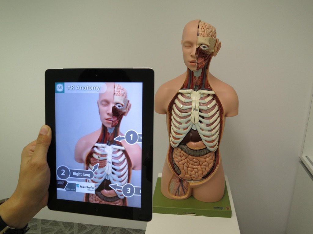
Integrate Augmented Reality Navigation Features
AR integration transforms your 3D mapping experience by overlaying digital information directly onto real-world environments. This technology bridges the gap between your immersive map visualization and actual navigation needs.
GPS-Based AR Overlays
Position your AR system using high-precision GPS coordinates to anchor virtual elements accurately in physical space. Modern AR frameworks like ARCore and ARKit achieve sub-meter accuracy when combined with RTK GPS corrections. Layer digital waypoints, property boundaries, and elevation contours directly onto your camera view using spatial anchoring techniques. Calibrate your coordinate transformation between WGS84 and local coordinate systems to prevent drift during extended navigation sessions.
Point-of-Interest Recognition
Detect landmarks automatically using computer vision algorithms that match real-world features to your 3D map database. Machine learning models trained on geographic feature datasets can identify buildings, monuments, and natural formations with 85-90% accuracy. Display contextual information cards when users point their device at recognized locations, pulling data from your spatial database. Update recognition models regularly using crowdsourced imagery to maintain accuracy as environments change over time.
Live Direction Guidance
Stream real-time routing calculations to your AR interface, showing turn-by-turn directions as floating arrows and path overlays. WebRTC protocols enable low-latency data transmission for responsive guidance updates. Adapt route visualization based on terrain difficulty, weather conditions, and user preferences stored in your mapping system. Integrate voice commands and haptic feedback to provide multi-sensory navigation cues that work effectively in various lighting conditions and outdoor environments.
Develop Multi-Sensory User Interfaces
Multi-sensory interfaces transform static 3D maps into dynamic experiences that engage users through touch, sound, and voice interactions. These interfaces create deeper spatial understanding by activating multiple sensory channels simultaneously.
Haptic Feedback Integration
Haptic feedback adds tactile sensations to your 3D mapping interface through vibration patterns and force responses. You’ll integrate haptic controllers like Xbox Wireless Controllers or specialized devices such as Ultraleap’s hand tracking sensors to provide terrain-based feedback. Configure vibration intensity to match elevation changes – gentle pulses for rolling hills and stronger vibrations for steep cliffs. Implement tactile boundary detection that buzzes when users cross geological formations or property lines. This feedback helps users understand spatial relationships without visual dependence, making your maps accessible to visually impaired users while enhancing immersion for all participants.
Control haptic motors easily with the DRV2605L module. It uses I2C communication and features an IN pin for versatile control, including analog audio input.

Spatial Audio Implementation
Spatial audio creates three-dimensional soundscapes that match your map’s geographic features and user interactions. You’ll implement Web Audio API or Unity’s Audio Source components to position sounds accurately within your 3D environment. Add ambient sounds like flowing water near rivers, wind effects at higher elevations, and urban noise in city areas. Configure directional audio cues that guide users toward points of interest through stereo panning and volume adjustments. Integrate real-time audio feedback for user actions – footstep sounds that change based on terrain materials and voice announcements for location updates. This audio layer helps users navigate intuitively while creating emotional connections to mapped locations.
Voice Command Controls
Voice command controls enable hands-free navigation through natural language processing and speech recognition systems. You’ll integrate Google Speech-to-Text API or Azure Cognitive Services to process user verbal inputs for map manipulation. Configure command sets for common actions like “zoom to downtown,” “show elevation data,” or “find nearest hospital.” Implement contextual voice responses that provide location information, directions, and feature descriptions through text-to-speech synthesis. Add voice confirmation for critical actions such as route planning or data layer changes. Program multi-language support to accommodate diverse user bases and include voice accessibility features for users with mobility limitations, ensuring your 3D maps remain functional across different interaction preferences.
Create Dynamic Data Storytelling Layers
Transform your 3D maps into compelling narratives by incorporating temporal and demographic data layers that reveal the story behind geographic spaces.
Historical Timeline Overlays
Integrate chronological data visualization to showcase how locations evolved over time through interactive timeline controls. You’ll layer historical imagery datasets like USGS Historical Topographic Maps alongside census records from different decades. Modern GIS platforms such as ArcGIS Online and QGIS enable temporal animation features that display urban expansion patterns, infrastructure development phases, and land use changes across multiple time periods simultaneously.
Learn essential map reading and navigation skills with this U.S. Army guide. Designed for practical use, it provides clear instructions for navigating any terrain.

Population and Demographic Visualizations
Deploy census tract data integration to create color-coded demographic heat maps that display population density variations across your 3D terrain. You can access American Community Survey datasets through Census Bureau APIs to visualize age distribution patterns, income levels, and ethnic composition data. Interactive choropleth mapping techniques transform raw demographic statistics into intuitive visual representations that highlight community characteristics and social geography patterns.
Economic and Social Data Integration
Incorporate socioeconomic indicator layers by connecting Bureau of Labor Statistics employment data with local business registry information to reveal economic activity clusters. You’ll overlay median household income data from census sources alongside commercial property assessments and zoning classifications. Advanced data visualization libraries like D3.js enable dynamic filtering capabilities that allow users to explore correlations between economic indicators and geographic features interactively.
Build Collaborative Virtual Exploration Tools
Transform your 3D mapping platform into a social exploration environment where multiple users can navigate and discover locations together in real-time.
Multi-User Navigation Sessions
Synchronize multiple participants within the same 3D map environment using WebRTC technology for seamless real-time collaboration. You’ll enable teams to explore complex terrains together by implementing shared viewport controls that allow designated session leaders to guide group navigation while maintaining individual camera freedom. Configure user avatars with distinct colors and labels to track participant locations across large-scale environments. Most professional platforms support 8-12 concurrent users per session without performance degradation.
Real-Time Location Sharing
Broadcast precise coordinate positions between session participants using GPS integration and manual pin-dropping functionality for enhanced collaborative mapping. You’ll create dynamic location markers that update every 2-3 seconds to maintain accuracy during active exploration sessions. Implement proximity alerts that notify users when team members approach within 100-meter radius zones of their current position. This feature proves especially valuable for field research teams and urban planning collaborations.
Community-Generated Content
Enable user-contributed annotations, photos, and contextual data layers that enrich your 3D mapping experience with crowd-sourced local knowledge. You’ll establish moderation workflows using automated content filtering combined with community reporting systems to maintain data quality standards. Integrate user-generated waypoints with star rating systems and timestamp metadata to create valuable exploration databases. Popular mapping platforms report 40-60% higher engagement rates when community contributions are actively encouraged and showcased.
Design Gamified Discovery Experiences
Transform your 3D maps into engaging game-like environments that motivate users to explore every corner of your virtual terrain. Gamification elements create compelling reasons for continued interaction while building user loyalty through progressive discovery mechanics.
Achievement-Based Exploration
Achievement systems drive exploration by rewarding users for discovering hidden locations, landmarks, and geographic features within your 3D environment. You’ll create digital badges for reaching elevation milestones, finding rare geological formations, or visiting all points of interest in specific regions. Progress indicators show completion percentages for different map sections, encouraging systematic exploration. Difficulty tiers unlock advanced terrain features as users demonstrate mapping proficiency, creating natural progression pathways that maintain long-term engagement with your cartographic content.
Interactive Challenges and Quests
Location-based missions guide users through structured exploration sequences that reveal geographic relationships and spatial patterns. You’ll design treasure hunts using coordinate systems, elevation puzzles requiring topographic analysis, and navigation challenges that teach proper map reading techniques. Time-limited events create urgency around seasonal geographic phenomena like migration patterns or weather systems. Collaborative quests enable team-based problem solving where multiple users must coordinate their positions to unlock shared discoveries, fostering community engagement within your mapping platform.
Progress Tracking and Rewards
Visual progress maps display user exploration coverage through color-coded completion overlays and statistical dashboards showing distance traveled and features discovered. You’ll implement point-based reward systems that convert geographic achievements into redeemable benefits like premium map layers or enhanced visualization tools. Leaderboards showcase top explorers while personal milestones celebrate individual achievements through customizable profile displays. Unlockable content provides access to specialized datasets, historical map overlays, or advanced analytical tools as users demonstrate sustained engagement with your 3D mapping environment.
Conclusion
The future of 3D mapping lies in your ability to blend cutting-edge technology with user-centered design. By implementing these six innovative approaches you’ll transform static maps into powerful engagement tools that captivate audiences and drive meaningful interactions.
Your success depends on choosing the right combination of features that align with your specific goals and audience needs. Whether you’re focusing on AR integration spatial audio or gamification elements the key is creating experiences that feel natural and intuitive.
Remember that the most effective 3D map experiences are those that solve real problems while delighting users. Start with one or two core features and gradually expand your capabilities as you gather user feedback and refine your approach.
Frequently Asked Questions
What is 3D mapping technology and how does it benefit businesses?
3D mapping technology creates immersive, interactive experiences that allow users to virtually explore spaces in great detail. It transforms traditional flat maps into dynamic tools that effectively captivate audiences and foster deeper engagement. Businesses can enhance how they present locations and interact with customers, leading to improved user experiences across various industries.
How does real-time elevation mapping work in 3D terrain visualization?
Real-time elevation mapping utilizes USGS Digital Elevation Models to provide accurate topographical data. This technology creates dynamic terrain visualizations that can be enhanced with live weather effects through APIs. The integration of geological layer data provides insights into subsurface information, helping users understand geological composition and land use possibilities.
What are AR navigation features in 3D mapping?
AR navigation features overlay digital information onto real-world environments using high-precision GPS coordinates. Users can view digital waypoints and property boundaries in their physical surroundings. Point-of-interest recognition through computer vision algorithms identifies landmarks and provides contextual information, while live direction guidance offers real-time routing calculations and multi-sensory navigation cues.
How do multi-sensory user interfaces enhance 3D mapping experiences?
Multi-sensory interfaces transform static 3D maps through touch, sound, and voice interactions. Haptic feedback provides tactile sensations for better spatial understanding, while spatial audio creates immersive soundscapes corresponding to geographic features. Voice command controls enable hands-free navigation through natural language processing, making maps accessible to users with mobility limitations.
What are dynamic data storytelling layers in 3D mapping?
Dynamic data storytelling layers transform 3D maps into compelling narratives by incorporating temporal and demographic data. Historical timeline overlays showcase location evolution using interactive controls and historical imagery. Color-coded demographic heat maps visualize population density and socioeconomic indicators, revealing economic activity clusters and community characteristics through advanced data visualization techniques.
How do collaborative features work in 3D mapping platforms?
Collaborative features enable multi-user navigation sessions allowing real-time exploration by multiple participants using WebRTC technology. Users can share precise locations and utilize dynamic markers for enhanced collaboration, particularly beneficial for field research and urban planning. Community-generated content allows users to contribute annotations and data layers, enriching the mapping experience.
What gamification strategies are used to enhance 3D mapping engagement?
Gamification transforms 3D maps into game-like environments through achievement-based exploration, where users earn rewards for discovering locations and reaching milestones. Interactive challenges guide users through structured exploration sequences. Progress tracking systems showcase achievements through visual progress maps and leaderboards, while offering redeemable benefits for sustained engagement and motivation.