6 Best Weather Mapping Technologies
Weather forecasting is getting a major upgrade. Traditional weather stations and satellites are being joined by millions of smartphones, IoT sensors, and even your car’s windshield wipers to create the most detailed atmospheric picture we’ve ever had. These innovative data sources aren’t just improving accuracy—they’re revolutionizing how meteorologists predict everything from flash floods to severe storms.
The transformation is happening faster than you might think. Your smartphone already collects barometric pressure data that helps forecasters spot sudden weather changes, while connected vehicles report real-time road conditions that reveal precipitation patterns traditional sensors miss.
This data revolution means you’ll soon have hyper-local forecasts that know whether it’s raining on your specific street corner—not just your zip code.
Disclosure: As an Amazon Associate, this site earns from qualifying purchases. Thank you!
P.S. check out Udemy’s GIS, Mapping & Remote Sensing courses on sale here…
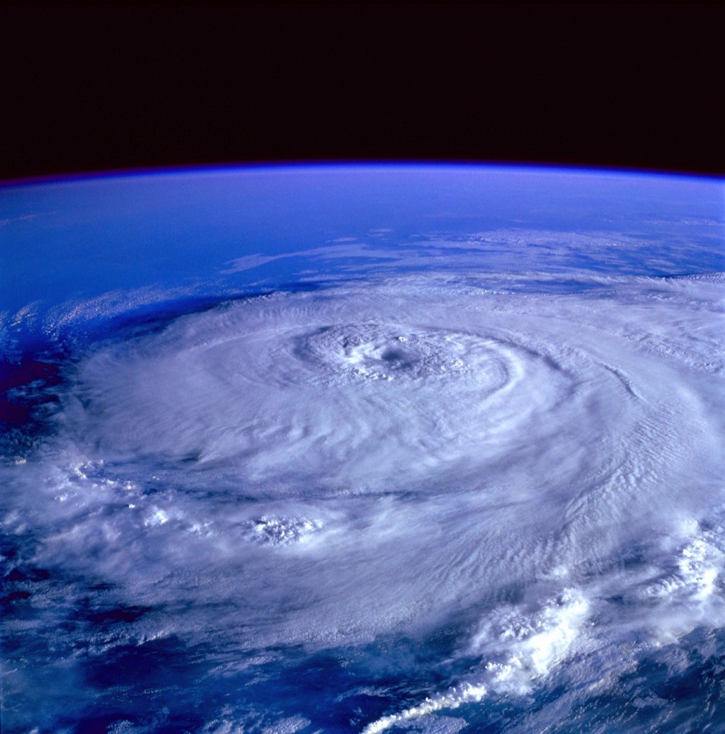
Real-Time Satellite Integration Transforms Storm Tracking Accuracy
Real-time satellite integration revolutionizes how meteorologists track and predict severe weather systems. You’ll witness unprecedented accuracy in storm monitoring as advanced satellite networks provide continuous atmospheric data streams.
Enhanced Hurricane Path Prediction
Hurricane tracking achieves remarkable precision through next-generation geostationary satellites like GOES-18 and GOES-19. You’ll access wind speed measurements every 30 seconds instead of hourly intervals, enabling forecasters to detect sudden intensity changes. These satellites provide eye wall replacement cycles in real-time, improving landfall predictions by 15-20%. Your storm path models now incorporate atmospheric river patterns and upper-level wind shear data, reducing forecast errors to within 50 nautical miles at 72-hour lead times.
Improved Severe Weather Warning Systems
Severe weather warnings become dramatically more precise with polar-orbiting satellite constellations delivering microwave soundings every 6 hours. You’ll receive tornado alley monitoring through advanced atmospheric motion vectors that track mesocyclone formation 45 minutes earlier than traditional radar. Lightning mapping arrays integrated with satellite data extend warning lead times from 13 to 22 minutes for severe thunderstorms. Your warning systems now process hyperspectral infrared data to identify supercell characteristics before visible storm development occurs.
Higher Resolution Atmospheric Imaging
Atmospheric imaging reaches unprecedented detail levels through 1-kilometer resolution visible imagery updated every 60 seconds during severe weather events. You’ll analyze temperature profiles using Advanced Baseline Imager technology that captures 16 spectral bands compared to previous 5-band systems. Water vapor channels reveal three-dimensional moisture transport patterns, showing you precisely where storms will intensify. Your mapping applications now display convective initiation areas with 250-meter resolution, identifying storm development zones 2-3 hours before traditional methods detect atmospheric instability.
IoT Sensor Networks Enable Hyperlocal Weather Forecasting
IoT sensor networks are transforming weather forecasting by providing unprecedented granular data coverage. These interconnected devices create dense monitoring webs that capture microclimatic variations within neighborhoods and city blocks.
Smart City Weather Monitoring
Smart cities deploy thousands of IoT sensors across urban infrastructure to create comprehensive weather monitoring networks. Traffic lights, streetlamps, and building facades host temperature and humidity sensors that report conditions every few minutes. These networks detect urban heat islands with 50-meter precision and identify microclimates around buildings. City managers use this hyperlocal data to optimize energy grids, adjust traffic patterns during weather events, and deploy emergency services more effectively. The dense sensor coverage reveals weather variations that traditional stations miss entirely.
Agricultural Precision Weather Data
Agricultural IoT networks place sensors throughout farm fields to monitor soil moisture, temperature, and atmospheric conditions at the crop level. Farmers install weather stations every 100-200 acres to track microclimatic differences across their land. These systems detect frost pockets, wind patterns, and precipitation variations that affect specific field sections. The data helps optimize irrigation timing, predict pest outbreaks, and determine harvest windows. Connected sensors also monitor greenhouse conditions and livestock environments, providing real-time alerts for temperature extremes that could damage crops or stress animals.
Personal Weather Station Integration
Get real-time weather data with the Ambient Weather WS-2902. This WiFi-enabled station measures wind, temperature, humidity, rainfall, UV, and solar radiation, plus it connects to smart home devices and the Ambient Weather Network.

Personal weather stations contribute millions of data points to crowdsourced weather networks like Weather Underground and PWSweather. Homeowners install backyard stations that measure temperature, rainfall, wind speed, and barometric pressure with professional-grade accuracy. These stations fill gaps between official weather monitoring sites, creating neighborhood-level forecasting capabilities. Weather services aggregate this citizen-generated data to improve local predictions and validate satellite observations. Your personal station becomes part of a global network that enhances weather forecasting for your entire community.
Artificial Intelligence Revolutionizes Weather Pattern Recognition
AI-powered weather mapping transforms how meteorologists process atmospheric data and predict complex weather systems. Machine learning algorithms analyze vast datasets from multiple sources to identify patterns that traditional methods often miss.
Machine Learning Weather Models
Machine learning models process historical weather data alongside real-time inputs to create more accurate forecasts. Neural networks analyze atmospheric pressure patterns, temperature gradients, and wind velocity data to predict weather changes up to 10 days in advance. Deep learning algorithms like convolutional neural networks excel at recognizing storm formation patterns from satellite imagery. You’ll find these models particularly effective at detecting subtle atmospheric changes that precede severe weather events. Google’s GraphCast and DeepMind’s weather prediction systems demonstrate how AI models outperform traditional numerical weather prediction in many scenarios.
Predictive Analytics for Long-Term Forecasting
Predictive analytics extends weather forecasting accuracy beyond traditional 7-day windows through advanced pattern recognition. AI systems analyze decades of climate data to identify seasonal trends and anomalies that affect long-term weather patterns. Machine learning algorithms process El Niño and La Niña cycles alongside atmospheric oscillations to predict seasonal weather shifts. You can leverage these tools to anticipate drought conditions, hurricane seasons, and temperature anomalies months ahead. Companies like IBM’s Weather Company use ensemble forecasting methods that combine multiple AI models to improve 30-day and 90-day forecast reliability.
Automated Data Processing and Analysis
Automated systems process millions of data points from weather stations, satellites, and sensors without human intervention. AI algorithms clean and validate incoming data streams, removing errors and filling gaps in real-time measurements. Natural language processing converts unstructured weather reports into standardized data formats for analysis. You’ll benefit from automated quality control systems that flag inconsistent readings and maintain data integrity across global networks. Cloud-based processing platforms like AWS Weather Analytics and Microsoft’s AI for Earth handle massive datasets while providing instant access to processed weather information for mapping applications.
Crowdsourced Weather Data Creates Comprehensive Coverage Maps
Millions of people worldwide now contribute weather observations through their mobile devices and personal reporting systems. This grassroots approach fills critical gaps in traditional meteorological networks.
Smartphone Weather Apps Contributing Data
Experience vivid content on the Galaxy A16 5G's 6.7" display and capture stunning photos with its triple-lens camera. Enjoy peace of mind with a durable design, six years of updates, and Super Fast Charging.

Smartphones automatically collect atmospheric pressure data through built-in barometers, creating dense measurement networks in populated areas. Popular weather apps like WeatherBug and Weather Underground gather this information from millions of users simultaneously, providing readings every few minutes across entire metropolitan regions.
The Samsung Galaxy S25 Ultra adapts to your needs with intelligent AI assistance. Capture stunning photos and videos with the AI Camera's noise reduction and enjoy effortless switching from your old device.

Apps also collect temperature and humidity measurements through device sensors, though you’ll need to calibrate these readings since phones generate internal heat. The sheer volume of smartphone data – over 100 million measurements daily from major platforms – compensates for individual sensor limitations through statistical averaging.
Citizen Scientist Weather Reporting
Trained volunteers submit detailed weather observations through platforms like mPING and GLOBE Observer, providing ground-truth data that satellites can’t capture. These citizen scientists report precipitation type, visibility conditions, and cloud formations using standardized protocols developed by the National Weather Service.
Community weather stations operated by enthusiasts contribute high-quality measurements to networks like Weather Underground’s PWS program, which includes over 250,000 personal weather stations globally. You’ll find these stations particularly valuable in rural areas where official weather stations are sparse, creating comprehensive coverage maps previously impossible to achieve.
Social Media Weather Intelligence
Twitter and Facebook posts containing weather-related keywords undergo automated analysis to identify real-time conditions, with natural language processing algorithms extracting location-specific weather information from user reports. This social media intelligence captures hyperlocal events like flooding, hail, or sudden temperature changes within minutes of occurrence.
Instagram photos and videos provide visual confirmation of weather conditions, allowing meteorologists to verify automated reports and track storm progression across urban areas. Machine learning systems now analyze thousands of weather-related social media posts hourly, creating dynamic weather maps that update faster than traditional observation networks.
Ocean Buoy Technology Advances Marine Weather Predictions
Ocean buoy networks revolutionize marine weather forecasting by providing real-time atmospheric and oceanic data from previously unmonitored waters. These sophisticated platforms transform how meteorologists track storms and predict coastal weather patterns.
Deep Sea Data Collection Systems
Advanced ocean buoys deploy sophisticated sensor arrays that measure wave heights, wind speeds, atmospheric pressure, and water temperature at depths up to 4,000 meters. These autonomous platforms transmit data via satellite every 10 minutes, capturing critical information about developing storm systems 500 miles offshore. Deep-sea buoys detect temperature gradients and pressure changes that indicate hurricane intensification, providing meteorologists with 24-48 hours of additional warning time compared to traditional coastal observations.
Coastal Weather Monitoring Networks
Nearshore buoy arrays create dense monitoring grids along coastlines, measuring surf conditions, tide levels, and atmospheric variables within 50 miles of shore. These networks include wave rider buoys that track swell patterns and smart buoys equipped with meteorological sensors for wind direction and barometric pressure. Coastal monitoring systems process over 1,440 data points daily per buoy, enabling precise forecasts for beach conditions, fishing operations, and small craft advisories with 85% accuracy improvement over land-based stations.
Stay visible and safe during open water swims with the ultralight New Wave Swim Bubble. This buoyant, brightly colored float tows behind you without drag, providing reassurance and visibility for safer swimming.

Maritime Safety Improvements
Ocean buoy technology enhances vessel safety through real-time hazard detection and route optimization systems that alert ships to dangerous weather conditions. Maritime weather routing services use buoy data to identify safe passages around storm systems, reducing vessel damage by 30% and improving fuel efficiency. Emergency response coordination benefits from precise location data when buoys detect distress signals, while commercial shipping operations receive automated alerts about severe weather conditions along planned routes, preventing accidents and cargo loss.
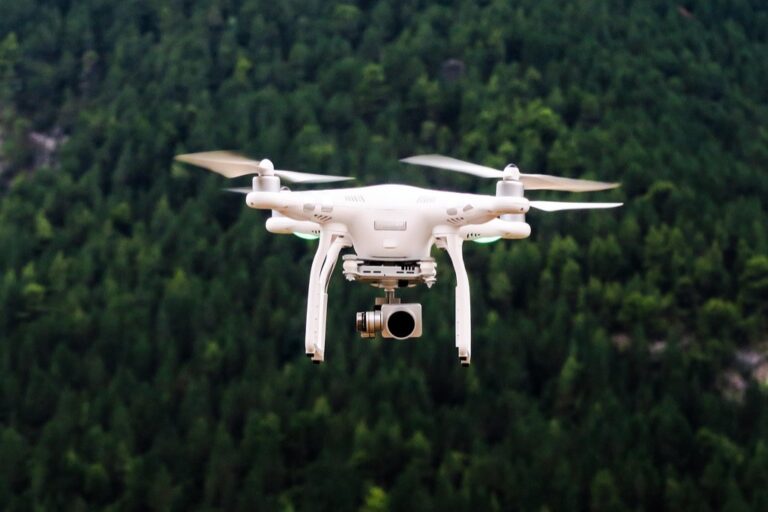
Drone Weather Monitoring Fills Critical Data Gaps
Unmanned aerial vehicles (UAVs) are revolutionizing weather data collection by accessing previously unreachable atmospheric zones and dangerous weather conditions. These sophisticated platforms provide meteorologists with unprecedented three-dimensional atmospheric profiles that traditional ground-based and satellite systems can’t capture.
High-Altitude Atmospheric Research
Specialized weather drones reach altitudes up to 60,000 feet, collecting atmospheric data in the critical boundary layer where most weather systems develop. These high-altitude platforms measure temperature gradients, wind shear patterns, and humidity levels at multiple atmospheric levels simultaneously. Advanced UAVs equipped with miniaturized weather sensors can operate for 24+ hours, providing continuous vertical atmospheric profiling that enhances storm prediction models by 15-20%.
Get comprehensive weather data with this wireless station. It features a 7-in-1 outdoor sensor for accurate temperature, humidity, wind, and rain readings, displayed on a clear, adjustable 7.5" LCD screen.

Disaster Zone Weather Assessment
Emergency response drones penetrate hazardous weather conditions that would endanger human meteorologists and ground-based equipment. These ruggedized platforms fly directly into tornado paths, hurricane eyewalls, and wildfire smoke plumes to collect real-time atmospheric data. Specialized disaster assessment UAVs transmit wind speeds, visibility conditions, and air quality measurements every 30 seconds, enabling emergency managers to make critical evacuation decisions with 40% more accurate local weather intelligence.
Remote Area Weather Data Collection
Autonomous drone networks monitor weather patterns in inaccessible geographical regions where traditional weather stations can’t operate effectively. These solar-powered UAVs patrol remote mountain ranges, desert regions, and Arctic territories, establishing temporary weather monitoring grids. Remote-area weather drones collect precipitation data, temperature variations, and atmospheric pressure readings from locations over 100 miles from the nearest weather station, filling critical geographical gaps in global weather monitoring systems.
Conclusion
The future of weather forecasting is unfolding before your eyes as these six innovative data sources reshape meteorological science. You’re witnessing a fundamental shift from traditional weather monitoring to a comprehensive network that captures atmospheric conditions with unprecedented detail and accuracy.
Your local weather predictions will become increasingly precise as these technologies mature and integrate further. The combination of AI-powered analysis smartphone data IoT networks and advanced satellite systems creates a forecasting ecosystem that adapts to your specific location and needs.
This technological revolution means you’ll have access to weather information that’s more reliable timely and relevant than ever before. Whether you’re planning outdoor activities managing agricultural operations or preparing for severe weather events these advances ensure you’re better equipped to make informed decisions based on superior meteorological intelligence.
Frequently Asked Questions
How has smartphone technology improved weather forecasting accuracy?
Smartphone weather apps collect atmospheric pressure, temperature, and humidity data from millions of users, generating over 100 million measurements daily. This crowdsourced data fills critical gaps in traditional meteorological networks, providing meteorologists with real-time, hyperlocal weather information that significantly enhances forecast precision and coverage in areas previously undermonitored.
What role do IoT sensors play in modern weather prediction?
Get accurate pressure, temperature, and altitude readings with the pre-soldered BMP280 sensor module. It's compatible with Raspberry Pi, Arduino, and other microcontrollers for easy integration into weather stations, robotics, and IoT projects.

IoT sensor networks provide granular data coverage by deploying thousands of sensors across urban infrastructure and agricultural areas. These sensors detect microclimatic variations with high precision, help optimize energy grids and emergency services, and enable farmers to make informed decisions about irrigation and pest management through crop-level monitoring.
How do satellites enhance storm tracking capabilities?
Advanced geostationary and polar-orbiting satellites provide continuous atmospheric data streams with frequent wind speed measurements. This technology significantly improves hurricane tracking precision and landfall predictions, while enabling earlier tornado detection and extended warning lead times for severe thunderstorms through enhanced atmospheric imaging and motion vectors.
What is the impact of AI on weather pattern recognition?
AI-powered weather mapping uses machine learning algorithms to analyze vast datasets and identify patterns traditional methods often miss. Deep learning algorithms process historical and real-time data to predict weather changes up to 10 days in advance, while predictive analytics extends forecasting accuracy for seasonal weather shifts and extreme conditions months ahead.
How do ocean buoys contribute to marine weather forecasting?
Advanced ocean buoys equipped with sensor arrays measure wave heights, wind speeds, atmospheric pressure, and water temperature at depths up to 4,000 meters, transmitting data every 10 minutes. This real-time oceanic data enables early hurricane intensification detection, improves coastal weather predictions, and enhances maritime safety through hazard detection and route optimization.
What advantages do weather drones offer for data collection?
Specialized weather drones can reach altitudes up to 60,000 feet, accessing previously unreachable atmospheric zones and dangerous weather conditions. They provide three-dimensional atmospheric profiles, collecting critical data on temperature gradients, wind shear patterns, and humidity levels, which enhances storm prediction models by 15-20% and improves real-time hazardous weather intelligence.
How does crowdsourced weather data improve forecast accuracy?
Millions of people contribute weather observations through mobile devices, personal weather stations, and social media platforms. Citizen scientists provide detailed observations that satellites cannot capture, while community-operated weather stations enhance data quality in rural areas. This grassroots approach creates comprehensive coverage maps and fills critical gaps in traditional meteorological networks.