6 Traditional vs Modern Land Methods That Transform Surveying
Why it matters: You’re living through a measurement revolution that’s transforming how we define property boundaries and calculate land areas.
The big picture: Traditional methods like chains and compass surveys dominated for centuries but they’re rapidly giving way to GPS satellites laser scanners and drone technology that can map entire properties in minutes rather than days.
This WoneNice handheld barcode scanner offers fast, reliable scanning for businesses. It's easy to install via USB and boasts a rapid 200 scans per second, compatible with Windows, Mac, and Linux.

What’s ahead: Understanding these six key differences between old and new approaches will help you make smarter decisions whether you’re buying property developing land or just curious about how surveyors work today.
Disclosure: As an Amazon Associate, this site earns from qualifying purchases. Thank you!
P.S. check out Udemy’s GIS, Mapping & Remote Sensing courses on sale here…
Traditional Land Measurement Methods Relied on Physical Tools and Manual Calculations
Before technological advances revolutionized surveying, you’d depend on tried-and-true physical instruments and time-consuming manual processes to measure land accurately.
Chain and Tape Measurements
Chain measurements formed the backbone of traditional surveying, requiring you to physically walk property boundaries with steel chains or measuring tapes. You’d stretch these tools across terrain while accounting for slopes, obstacles, and chain corrections due to temperature changes. Surveyors typically used 66-foot Gunter’s chains or 100-foot engineer’s chains, marking distances with stakes and recording measurements in field books. This method demanded multiple team members and could take days to complete what modern tools accomplish in hours.
Get accurate measurements with this 25-foot retractable tape measure. Features an easy-to-read blade and durable construction with a riveted end hook.

Compass and Theodolite Surveying

Compass and theodolite instruments enabled you to measure horizontal and vertical angles with remarkable precision for their era. You’d set up these heavy brass instruments on tripods, carefully level them, and take multiple readings to establish property corners and boundary lines. Theodolites measured angles to seconds of arc, while magnetic compasses provided directional bearings despite declination variations. Weather conditions significantly affected accuracy, and you’d often need to return multiple times to verify critical measurements.
Manual Record Keeping
Manual record keeping required you to meticulously document every measurement, calculation, and observation in leather-bound field books using pencil or ink. You’d sketch property boundaries, note natural landmarks, and perform trigonometric calculations by hand using logarithm tables. Creating final survey plats involved drafting with specialized pens, rulers, and compasses on vellum or paper. This process took weeks to complete, and any errors meant starting calculations over from the beginning.
Protect your 3.5 x 5.5 inch field notes with this durable full-grain leather cover. It features a convenient card and pen holder for effortless organization on the go.

Modern Land Measurement Methods Utilize Advanced Technology and Digital Systems
Today’s surveying landscape transforms traditional measurement approaches through sophisticated technology and digital integration. Modern land measurement methods deliver unprecedented accuracy and efficiency compared to their historical counterparts.
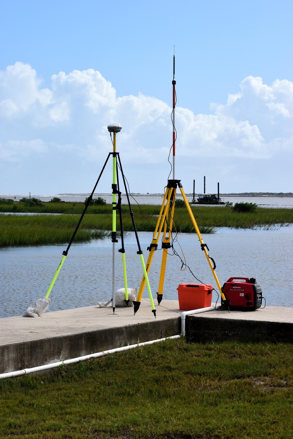
GPS and Satellite Technology
GPS systems provide centimeter-level accuracy through satellite constellation networks that triangulate positions from space. You’ll find Real-Time Kinematic (RTK) GPS units achieving precision within 1-2 centimeters, dramatically reducing measurement time from days to hours. Modern surveyors utilize multi-constellation receivers that connect to GPS, GLONASS, and Galileo satellites simultaneously, ensuring reliable positioning even in challenging environments with tree cover or urban obstacles.
Navigate with ease using this 7-inch GPS navigator, featuring real-time voice guidance and pre-loaded 2025 maps. Customize routes based on your vehicle type to avoid restrictions and receive speed & red light warnings.

Electronic Distance Measurement (EDM)
EDM instruments use laser technology to measure distances with millimeter precision across several kilometers without physical contact. You can complete boundary measurements in minutes rather than hours using total stations that combine EDM with electronic theodolites for simultaneous distance and angle calculations. These devices automatically correct for atmospheric conditions and temperature variations, eliminating human error factors that affected traditional chain measurements and providing consistent accuracy regardless of terrain challenges.
This 15-piece natural wood percussion set encourages musical exploration and creativity. Includes a variety of instruments with a safe, round-edge design and a convenient storage bag.

Digital Data Management
Digital systems automatically capture, store, and process measurement data through integrated software platforms that eliminate manual calculation errors. You’ll benefit from cloud-based data storage that enables real-time collaboration between field crews and office personnel, reducing project completion times by 60-70%. Modern surveying software generates automated reports, CAD drawings, and legal descriptions directly from field measurements, transforming weeks of manual documentation into same-day deliverables with built-in quality control checks.
Accuracy Levels Differ Significantly Between Traditional and Modern Approaches
The accuracy gap between traditional and modern land measurement methods represents one of the most dramatic improvements in surveying technology.
Traditional Method Margins of Error
Traditional surveying methods typically produce accuracy levels ranging from 1:1,000 to 1:5,000 ratios. Chain measurements accumulate errors of 1-3 feet per 1,000 feet measured due to temperature variations and chain sag. Compass surveys introduce angular errors of 15-30 minutes of arc, while manual calculations compound these discrepancies. Weather conditions further reduce precision, with humidity affecting steel chains and wind impacting instrument stability during measurements.
Modern Technology Precision Standards
Modern surveying achieves accuracy levels of 1:10,000 to 1:100,000 ratios through advanced instrumentation. GPS systems deliver centimeter-level precision with error margins under 0.1 feet for most applications. Total stations provide angular accuracy within 1-5 seconds of arc, while laser scanning technology measures distances with millimeter precision. Digital processing eliminates human calculation errors, and automated data collection reduces field measurement mistakes by up to 95% compared to traditional methods.
Time Requirements Vary Dramatically for Land Surveying Projects
Surveying project timelines represent one of the most significant differences between traditional and modern measurement approaches. The time investment required can influence project costs, client satisfaction, and overall efficiency in land development initiatives.
Traditional Surveying Timeline Constraints
Traditional surveying methods required extensive field time and manual processing phases that stretched project timelines significantly. You’d typically spend 3-5 days measuring a 10-acre property using chain and compass techniques, followed by 2-3 weeks of manual calculations and hand-drawn plan preparation. Weather delays, equipment setup requirements, and multiple site visits for verification often extended these timelines by an additional 30-50%. Complex boundary disputes or irregular property shapes could push completion times to 6-8 weeks for standard residential surveys.
Modern Efficiency and Speed Benefits
Modern surveying technologies compress traditional timelines into manageable timeframes through automated data collection and digital processing capabilities. You can complete the same 10-acre property survey in 4-6 hours using GPS and total station equipment, with digital processing reducing office work to 1-2 days maximum. Drone surveys capture comprehensive site data in 30-60 minutes, while laser scanning technology maps complex structures in hours rather than days. Real-time data validation and cloud-based processing eliminate most verification visits, reducing overall project completion times by 75-85%.
Cost Structures Show Distinct Differences in Equipment and Labor Expenses
While traditional and modern land measurement methods both achieve surveying objectives, their financial investment patterns create vastly different budget requirements and long-term cost implications.
Traditional Method Investment Requirements
Traditional surveying requires lower initial equipment costs but higher ongoing labor expenses. You’ll typically invest $5,000-$15,000 for basic instruments including theodolites, steel chains, measuring tapes, and manual calculation tools. However, labor costs dominate your budget since traditional methods demand 3-5 surveyors per project working extended field hours. Personnel expenses account for 70-80% of total project costs, with experienced surveyors commanding $25-$40 per hour rates.
Modern Technology Cost-Benefit Analysis
Modern measurement technology demands significant upfront investment but delivers substantial long-term savings through efficiency gains. You’ll face initial equipment costs of $50,000-$200,000 for GPS systems, laser scanners, drones, and software licenses. However, reduced labor requirements offset these expenses since one operator can accomplish work previously requiring multiple surveyors. Projects complete 75-85% faster with 60% fewer labor hours, creating cost savings of $10,000-$30,000 per major survey project within the first year.
Data Storage and Accessibility Present Contrasting Approaches
Traditional and modern surveying methods showcase fundamentally different approaches to data management and information accessibility. These contrasting systems directly impact project efficiency and long-term record maintenance.
Traditional Paper-Based Documentation
Traditional surveying relies on physical documentation systems that require extensive manual record-keeping. You’ll find surveyors creating hand-drawn field notes, maintaining leather-bound survey books, and storing paper maps in filing cabinets. These documents often include measurements written in ink, sketch drawings of property boundaries, and calculation sheets filled with trigonometric computations. Physical storage systems demand considerable office space, with some surveying firms maintaining archives spanning decades in warehouse facilities.
Modern Cloud-Based Digital Archives
Modern surveying transforms data management through cloud-based digital storage systems that provide instant accessibility from anywhere. You’ll access survey data through secure online platforms, view interactive maps on mobile devices, and share project files with clients in real-time. Digital archives include GPS coordinates stored in databases, high-resolution aerial imagery, and 3D point cloud data from laser scanning. Cloud storage eliminates physical space requirements while enabling automated backups, version control, and collaborative editing capabilities across multiple team members simultaneously.
Conclusion
Understanding these fundamental differences between traditional and modern land measurement methods empowers you to make better decisions for your surveying needs. Whether you’re considering cost implications or accuracy requirements your choice will significantly impact your project’s success.
The surveying industry’s digital transformation offers compelling advantages that extend far beyond simple efficiency gains. You’ll find that modern methods provide superior accuracy data management and time savings that traditional approaches simply can’t match.
Your specific project requirements budget constraints and timeline expectations should guide your decision-making process. By weighing these factors against the capabilities of each approach you can select the surveying method that best serves your property measurement objectives.
Frequently Asked Questions
What is the main difference between traditional and modern land surveying methods?
Traditional surveying relies on physical tools like chains, compasses, and manual calculations, while modern surveying uses advanced technology such as GPS satellites, laser scanners, and drones. Modern methods offer significantly higher accuracy (1:10,000 to 1:100,000 ratios) compared to traditional methods (1:1,000 to 1:5,000 ratios) and complete projects 75-85% faster.
How long does traditional surveying take compared to modern methods?
Traditional surveying typically requires 3-5 days for field measurements followed by 2-3 weeks of manual processing, with complex cases extending to 6-8 weeks. Modern surveying can complete a 10-acre property survey in just 4-6 hours, with digital processing reducing office work to 1-2 days, achieving overall time reductions of 75-85%.
What are the cost differences between traditional and modern surveying?
Traditional surveying has lower initial equipment costs ($5,000-$15,000) but higher ongoing labor expenses (70-80% of project budgets). Modern technology requires higher upfront investment ($50,000-$200,000) but offers substantial long-term savings of $10,000-$30,000 per major survey project within the first year through efficiency gains and reduced labor hours.
How accurate are modern surveying methods compared to traditional ones?
Modern surveying achieves exceptional accuracy levels of 1:10,000 to 1:100,000 ratios, with GPS systems providing centimeter-level precision and laser scanning offering millimeter precision. Traditional methods typically produce accuracy levels of 1:1,000 to 1:5,000 ratios, with various factors like weather conditions and temperature variations contributing to errors.
What technology is used in modern land surveying?
Modern surveying utilizes GPS satellites for precise positioning, laser scanners for detailed measurements, drones for aerial data capture, and total stations for angular accuracy within 1-5 seconds of arc. Digital processing systems eliminate human calculation errors and provide cloud-based storage with real-time accessibility and collaboration capabilities.
How has data management changed in modern surveying?
Traditional surveying relies on physical documentation with hand-drawn field notes and paper maps stored in filing cabinets, requiring extensive office space. Modern surveying uses cloud-based digital storage systems that provide instant accessibility from anywhere, automated backups, version control, and real-time sharing capabilities, eliminating physical storage requirements entirely.