6 Best Digital Map Conversion Methods
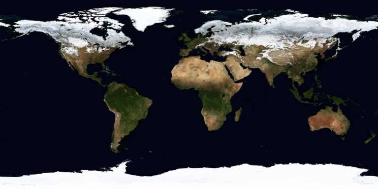
Digital map conversion presents a critical challenge: preserving the historical integrity and authenticity of original cartographic materials while making them accessible in modern formats. You’re dealing with centuries-old maps that contain unique artistic elements, precise geographical data, and cultural significance that can easily be lost during the digitization process.
The stakes are high when converting analog maps to digital formats. Libraries, museums, and research institutions must balance technological advancement with preservation accuracy to maintain scholarly value and historical credibility.
Successful digital conversion requires specific methodologies that protect both the visual authenticity and informational integrity of your original maps while creating usable digital assets for research and education.
Disclosure: As an Amazon Associate, this site earns from qualifying purchases. Thank you!
P.S. check out Udemy’s GIS, Mapping & Remote Sensing courses on sale here…
Preserve Original Color Schemes and Visual Elements
Color palettes and visual elements form the aesthetic foundation of historical maps, requiring careful preservation during digital conversion. Your scanning methodology must capture these distinctive characteristics while maintaining their historical accuracy.
Achieve a flawless, even complexion with e.l.f. Flawless Satin Foundation. This lightweight, vegan formula provides medium coverage and a semi-matte finish for all-day wear, while hydrating your skin with glycerin.

Maintain Historical Color Palettes
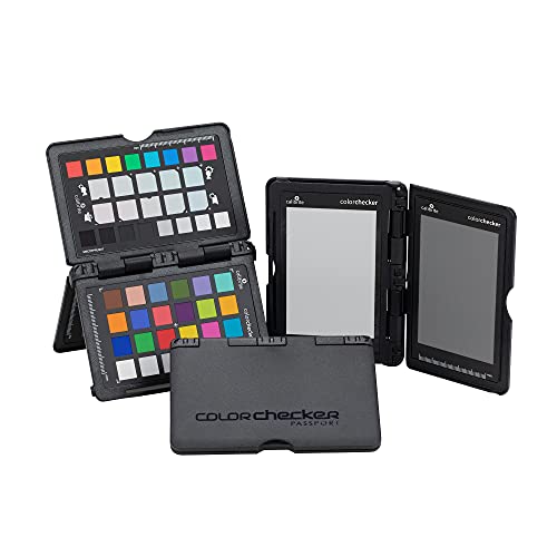
Historical maps feature unique pigments and ink formulations that create specific color relationships you can’t replicate with modern printing. You’ll need to calibrate your scanning equipment using ColorChecker targets and document the original map’s color temperature under standardized lighting conditions. Professional archival scanners capture 48-bit color depth to preserve subtle tonal variations in aged inks, weathered paper, and faded pigments. Create custom ICC profiles for each map collection to ensure color accuracy across different viewing devices and future reproduction needs.
Achieve consistent and accurate colors with this portable Passport. Create custom camera profiles for DNG and ICC workflows, and easily set in-camera white balance.
Retain Original Typography and Fonts
Typography preservation requires high-resolution scanning at minimum 600 DPI to capture letterform details, serif characteristics, and hand-lettered variations. You’ll encounter period-specific typefaces, engraved lettering, and calligraphic elements that define the map’s historical context. Document font families, stroke weights, and spacing measurements before digitization begins. Use vector tracing software like Adobe Illustrator to recreate damaged text elements while maintaining the original’s typographic personality. Archive both raster scans and vector recreations to support future scholarly research and reproduction projects.
Learn Adobe Illustrator with the 2025 release of this comprehensive guide. Master essential skills through hands-on lessons.

Keep Decorative Cartographic Elements
Cartographic decorations including compass roses, scale bars, ornamental borders, and illustrated vignettes require specialized attention during digital conversion. You’ll need to balance detail preservation with file size management when capturing intricate engravings and watercolor illustrations. Scan decorative elements at higher resolutions than base map features to maintain their artistic integrity. Create separate image layers for ornamental components to enable selective enhancement without affecting underlying geographic data. Document the cultural significance and artistic techniques used in these elements to preserve their historical context alongside visual accuracy.
Create vibrant watercolor art with this portable set. It includes 40 colors (metallic & fluorescent), a brush pen, watercolor paper, and more, all in a stylish tin box.

Document and Reference Source Materials Thoroughly
Comprehensive documentation forms the foundation of any successful map digitization project. You’ll need systematic record-keeping to maintain authenticity throughout the conversion process.
Create Detailed Provenance Records
Document your map’s complete history including acquisition date, previous ownership, and any restoration work performed. Record the original publication details such as cartographer name, printing house, and estimated creation year. Photograph any publisher’s marks, stamps, or annotations that provide historical context before scanning begins. Include measurements of the physical map dimensions and note any damage or deterioration patterns that affect digitization decisions. Maintain these records in standardized metadata formats like Dublin Core to ensure long-term accessibility for researchers and institutions.
Maintain High-Resolution Master Files
Capture your original maps at 600 DPI minimum using professional archival scanners to preserve fine details and texture. Save master files in uncompressed TIFF format to avoid quality degradation during future edits or format conversions. Create multiple resolution versions including a preservation master, access copy, and thumbnail for different research needs. Store color calibration data alongside each scan to maintain accurate color reproduction across different display systems. Document your scanning equipment specifications and settings for each digitization session to ensure consistent results.
Establish Version Control Systems
Implement systematic file naming conventions that track each revision stage from raw scan to final processed image. Use version numbers like “MapName_v01_rawscan.tiff” and “MapName_v03_coloradjusted.tiff” to maintain clear editing histories. Create backup copies at each major processing milestone to prevent data loss and enable rollback capabilities. Document all digital enhancements or corrections in accompanying text files that explain your decision-making process. Store multiple copies across different storage systems including cloud backup and physical media for redundancy protection.
Implement Proper Scanning and Digitization Techniques
Your scanning methodology directly determines the visual fidelity and long-term preservation value of digitized historical maps.
Use Professional-Grade Equipment
Professional archival scanners deliver superior results compared to standard office equipment when digitizing historical maps. Large-format scanners like the Cruse Scanner or Zeutschel OS series handle oversized maps without folding or damage. Flatbed scanners with overhead lighting systems prevent shadows and ensure even illumination across the entire map surface. Contact-free scanning eliminates physical pressure on fragile materials while maintaining precise focus throughout the digitization process.
Scan large documents quickly with the Plustek S30. This wide-format scanner handles documents up to 12" wide and includes a 100-sheet duplex auto document feeder for efficient, high-volume scanning.

Apply Correct Resolution Standards
Capture maps at minimum 600 DPI resolution to preserve fine cartographic details and enable future zoom functionality. Academic institutions typically scan at 800-1200 DPI for maps containing intricate typography or decorative elements. Higher resolutions of 1200+ DPI prove essential for maps with damaged areas requiring digital restoration. Store master files in uncompressed TIFF format to prevent quality degradation during repeated access and manipulation.
Ensure Proper Color Calibration
Calibrated color management systems maintain historical accuracy throughout the digitization workflow. Use IT8 color targets and spectrophotometers to establish baseline color profiles before scanning sessions. Document ambient lighting conditions and scanner lamp temperatures to ensure consistent results across multiple scanning sessions. Create custom ICC profiles for each historical map collection to account for period-specific pigments and ink formulations that may not match modern color spaces.
See your shots instantly with these 10" reactive splatter targets. The multi-color design on heavy-duty tag board reveals each hit clearly, perfect for firearms, airsoft, or BB guns.

Maintain Geographic Accuracy and Coordinate Systems
Geographic precision forms the foundation of authentic digital map conversions. You’ll need to preserve the original mathematical framework that defines spatial relationships within your historical maps.
Preserve Original Projection Methods
Identify the source projection before beginning your digital conversion process. Historical maps often use outdated projection systems like Cassini-Soldner or local coordinate grids that require specialized handling. Document the original projection parameters including false easting, false northing, and central meridian values. Use GIS software like ArcGIS Pro or QGIS to maintain these original projection definitions rather than automatically converting to modern standards. Store projection metadata within your digital files using GeoTIFF tags or world files to ensure future users understand the mathematical foundation of your converted map.
Verify Spatial Reference Information
Cross-check coordinate systems against historical surveying records and contemporary reference materials. Compare your digitized map’s control points with known geographic features using tools like the National Geodetic Survey database or historical triangulation station records. Validate datum information since many historical maps use local datums that differ significantly from modern NAD83 or WGS84 systems. Create transformation parameters when necessary but document any adjustments made during the verification process. Test your spatial reference accuracy by overlaying digitized features with modern satellite imagery or topographic maps.
Cross-Reference Geographic Data
Compare geographic features across multiple authoritative sources to ensure positional accuracy during conversion. Use contemporary topographic maps, aerial photography, and cadastral records to verify the placement of roads, waterways, and boundary lines. Check elevation data against Digital Elevation Models (DEMs) when working with topographic maps that include contour information. Validate place names and geographic nomenclature using the Geographic Names Information System (GNIS) or historical gazetteers. Document any discrepancies between your source map and reference materials, noting potential surveying errors or intentional artistic liberties taken by the original cartographer.
Apply Appropriate Metadata and Attribution Standards
Proper metadata standards ensure your digitized maps remain discoverable and academically credible. Digital preservation requires systematic documentation that follows established library science protocols.
Include Comprehensive Cataloging Information
Catalog your digitized maps using Dublin Core metadata standards, incorporating title, subject headings, geographic coverage, and scale information. Record specific details including map dimensions, original materials used, and condition assessments at the time of digitization. Document unique identifiers, collection numbers, and cross-references to related cartographic materials in your institutional database. Include Library of Congress subject headings and geographic coordinate boundaries to enhance searchability across digital repositories.
Add Creator and Publication Details
Identify original cartographers, engravers, and publishers with complete names and biographical context when available. Document publication dates, printing methods, and edition information to establish the map’s place in cartographic history. Record copyright holders and licensing restrictions that affect digital distribution and usage rights. Include information about commissioned work, institutional affiliations, and any collaborative efforts involved in the map’s creation, ensuring proper attribution for scholarly citations.
Document Historical Context
Capture the socio-political circumstances surrounding the map’s creation, including territorial disputes, exploration campaigns, or administrative changes it represents. Record the intended audience and purpose, whether for navigation, military planning, or educational use. Document contemporary events that influenced cartographic decisions, such as treaty negotiations or scientific discoveries that shaped geographic understanding. Include connections to other maps in the series or collection, establishing relationships that provide researchers with broader historical context.
Establish Quality Control and Validation Processes
Implementing systematic validation processes ensures your digitized historical maps maintain their authenticity and scholarly value throughout the conversion workflow.
Conduct Regular Accuracy Audits
Schedule weekly accuracy audits to verify color fidelity, spatial accuracy, and metadata completeness across your digitization batches. Compare random samples of your digitized maps against original materials using calibrated monitors and standardized viewing conditions. Document any discrepancies in resolution, color matching, or geometric accuracy to identify patterns that require process adjustments. Maintain audit logs that track scanning parameters, color profiles, and operator performance metrics to ensure consistent quality standards.
Implement Peer Review Systems
Establish multi-reviewer validation teams where cartographers, archivists, and subject matter experts independently assess digitized maps before final approval. Assign specific review criteria including projection accuracy, historical context verification, and technical quality assessment to each reviewer type. Create standardized review forms that capture feedback on spatial reference systems, metadata accuracy, and visual fidelity to streamline the evaluation process. Schedule regular reviewer calibration sessions to maintain consistent evaluation standards across your quality control team.
Create Feedback Loops for Improvements
Develop structured feedback mechanisms that capture user reports, researcher observations, and technical issues discovered post-publication. Implement version control systems that allow you to track corrections and improvements while maintaining clear revision histories for each digitized map. Establish monthly review meetings where scanning technicians, quality control specialists, and end users discuss recurring problems and propose workflow refinements. Use feedback data to update scanning protocols, adjust color profiles, and refine metadata standards for future digitization projects.
Conclusion
Successfully preserving map authenticity during digital conversions requires your commitment to technical excellence and historical accuracy. By implementing these six methodologies you’ll ensure that digitized maps maintain their scholarly value while becoming accessible to modern researchers.
The investment in proper equipment calibrated scanning and comprehensive documentation pays dividends through enhanced preservation and research capabilities. Your attention to geographic accuracy metadata standards and quality control processes creates a robust foundation for long-term digital archival success.
Remember that each historical map represents irreplaceable cultural heritage. When you apply these proven techniques you’re not just creating digital copiesâyou’re safeguarding cartographic history for future generations while enabling new discoveries through improved accessibility.
Frequently Asked Questions
What are the main challenges in digitizing historical maps?
The primary challenges include preserving authenticity and integrity while converting centuries-old maps to digital formats. Key difficulties involve maintaining original color schemes, typography, and decorative elements without losing their artistic and cultural value. Balancing technological advancement with historical accuracy requires specialized equipment, proper documentation, and careful attention to detail throughout the digitization process.
What scanning resolution is recommended for historical map digitization?
Historical maps should be scanned at a minimum of 600 DPI using professional-grade scanners. Higher resolutions are recommended for maps with intricate details or damage. Large-format flatbed scanners with overhead lighting are preferred to avoid physical damage and ensure even illumination. Uncompressed TIFF format should be used for master files to maintain maximum quality.
How important is color accuracy in map digitization?
Color accuracy is crucial for preserving historical authenticity. Original pigments and ink formulations must be captured precisely using calibrated scanning equipment and professional archival scanners. IT8 color targets and spectrophotometers should be used for proper color calibration. Color calibration data should be stored alongside scans to maintain consistency and historical accuracy throughout the process.
What metadata standards should be used for digitized historical maps?
Dublin Core metadata standards are recommended for cataloging digitized maps. Essential information includes title, subject headings, geographic coverage, scale, creator details, publication dates, and copyright information. Historical context such as socio-political circumstances and intended audience should also be documented to provide researchers with comprehensive understanding of the map’s significance and place in cartographic history.
How should geographic accuracy be maintained during digitization?
Geographic accuracy requires preserving the original mathematical framework and projection methods that define spatial relationships. Projection parameters should be documented using GIS software to maintain these definitions. Spatial reference information must be verified by cross-checking coordinate systems against historical records and contemporary materials, with any discrepancies and adjustments thoroughly documented for research integrity.
What quality control measures are essential for map digitization projects?
Quality control involves conducting regular accuracy audits to verify color fidelity, spatial accuracy, and metadata completeness. Audit logs should track scanning parameters and operator performance. Implementing peer review systems where experts assess digitized maps against specific criteria is crucial. Creating feedback loops to capture user observations helps continuously improve workflows and maintain high preservation standards.
How should decorative elements be preserved in digital maps?
Decorative elements like compass roses and ornamental borders require special attention during digitization. These intricate details should be captured using separate image layers to preserve their complexity. Their cultural significance must be thoroughly documented. High-resolution scanning ensures these artistic elements retain their visual impact and historical value in the digital format.
What file management practices are recommended for digitized maps?
Proper file management includes maintaining high-resolution master files in uncompressed TIFF format with complete color calibration data. Version control systems should track all revisions and maintain clear editing histories. Data redundancy through multiple storage methods is essential. Detailed provenance records documenting the map’s history, restoration work, and digitization process should accompany all digital files.