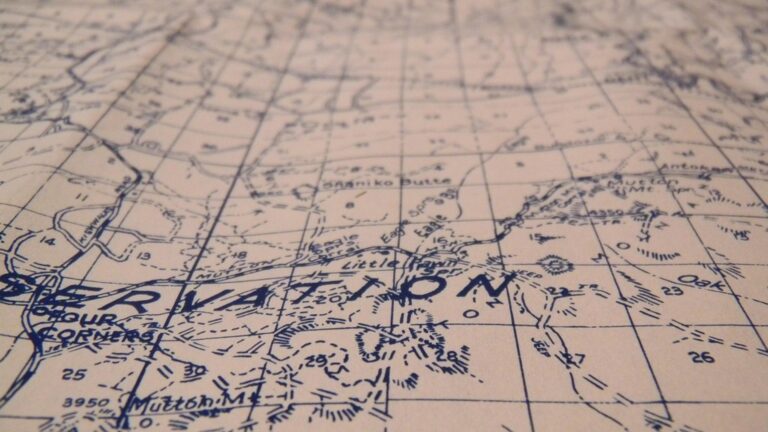
7 Best Map Typography Tips
Why it matters: Typography makes or breaks your map’s readability and professional appearance — yet most cartographers struggle with creating consistent text styles across different map elements.
Explore and map the wilderness for the Queen in Cartographers! Draw unique terrain shapes and score points based on randomly selected goals each game, but beware of monster ambushes.

The big picture: A cohesive typography system helps your audience quickly understand hierarchies between cities states and landmarks while maintaining visual harmony throughout your design.
What’s next: These seven proven strategies will transform your maps from cluttered text disasters into clean professional visualizations that guide readers exactly where you want them to look.
Disclosure: As an Amazon Associate, this site earns from qualifying purchases. Thank you!
P.S. check out Udemy’s GIS, Mapping & Remote Sensing courses on sale here…
Choose a Consistent Font Family System
Your map’s typography foundation starts with establishing a coherent font family system that guides all text decisions. This systematic approach prevents the visual chaos that occurs when multiple unrelated typefaces compete for attention across your cartographic elements.
Achieve a flawless, even complexion with e.l.f. Flawless Satin Foundation. This lightweight, vegan formula provides medium coverage and a semi-matte finish for all-day wear, while hydrating your skin with glycerin.

Select Primary and Secondary Typefaces
Choose one primary typeface for major geographic labels like cities, countries, and primary features. Select a secondary typeface that complements your primary choice for supporting elements such as legends, scale bars, and annotations. Popular cartographic combinations include Helvetica for primary labels paired with Georgia for descriptive text, or custom font families like National Geographic’s proprietary system that maintains consistency across all their mapping products.
Establish Hierarchy Through Font Weights
Create clear information hierarchy using weight variations within your chosen font family rather than switching between different typefaces. Use bold weights for capital cities, medium weights for major towns, and light weights for smaller settlements. This approach maintains visual unity while clearly communicating the relative importance of geographic features. Professional mapping software like ArcGIS Pro and QGIS offer precise weight controls that help you establish these hierarchical relationships systematically.
Consider Readability at Different Zoom Levels
Test your font choices at multiple scale levels to ensure consistent readability across your map’s intended zoom range. What appears crisp at 1:10,000 scale may become illegible at 1:100,000 scale. Sans-serif fonts like Arial or Calibri typically perform better at smaller sizes, while serif fonts can enhance readability for larger text blocks. Digital mapping platforms require particular attention to screen resolution variations, so test your typography on both high-DPI displays and standard monitors.
Experience smooth, tear-free gaming and video with the Acer KB272 G0bi 27" Full HD monitor, featuring Adaptive-Sync (FreeSync Compatible) and a rapid 1ms response time. Enjoy vibrant colors with 99% sRGB coverage and versatile connectivity through HDMI and VGA ports.

Develop a Strategic Color Palette for Text Elements
Your text color choices directly impact map readability and information hierarchy. A cohesive color palette ensures your typography system functions effectively across all map elements.
Create Contrast Between Text and Background
Establish sufficient contrast ratios between your text and background elements to ensure readability at various scales. Use dark text on light backgrounds for primary labels and reverse this approach for specialized elements like water features. Test your contrast ratios using tools like WebAIM’s contrast checker to verify WCAG AA compliance. Consider how your chosen colors will appear when printed on different paper types or displayed on various screen types.
Enjoy refreshing water with the Avalon Bottom Loading Water Cooler. It offers hot, cold, and room temperature options, a BioGuard anti-microbial coating, and a child safety lock for peace of mind.

Use Color to Differentiate Information Types
Assign specific colors to distinct information categories to create visual hierarchy and improve map comprehension. Reserve black or dark gray for primary geographic features like cities and major roads. Use blue tones for water-related labels including rivers, lakes, and coastal features. Apply earth tones like brown or dark green for topographic elements such as mountains and parks. Maintain consistent color assignments across your entire map series to build user familiarity.
Maintain Accessibility Standards
Follow accessibility guidelines to ensure your maps serve users with various visual capabilities. Avoid using color alone to convey critical information – combine color with font weight, size, or style variations. Test your color palette using colorblindness simulators to verify that red-green colorblind users can distinguish between different label types. Use sufficient color contrast ratios that meet WCAG 2.1 AA standards for normal text (4.5:1) and large text (3:1).
Establish Clear Typography Hierarchy Rules
Typography hierarchy rules form the backbone of professional map design, ensuring your text elements communicate geographic importance through systematic visual relationships.
Define Size Relationships Between Label Types
Size relationships create immediate visual hierarchy across your map elements. Establish a mathematical ratio system where country labels measure 16-18pt, state labels use 12-14pt, and city labels range from 8-10pt. This 1.3x scaling ratio maintains proportional relationships while ensuring readability. Reserve your largest sizes for continental or ocean labels, stepping down systematically to neighborhood-level features.
Set Consistent Spacing Guidelines
Spacing consistency prevents visual clutter and improves map readability across different zoom levels. Apply uniform letter-spacing of 0.05em for capital letters in major labels and maintain line spacing at 1.2x your font size. Keep minimum 3pt clearance between text and geographic features, with 6pt spacing between different label categories. These measurements ensure adequate breathing room while maintaining professional density standards.
Create Visual Weight Distribution
Visual weight distribution balances information density throughout your map composition. Use bold weights sparingly for primary geographic features like capitals or major rivers, medium weights for secondary elements, and light weights for supplementary information. Distribute heavy text elements across quadrants to avoid visual clustering. This systematic approach prevents any single map area from becoming text-heavy while maintaining clear feature prominence.
Create Standardized Label Placement Guidelines
Your label placement decisions directly determine whether readers can efficiently extract information from your map. Consistent positioning rules eliminate the guesswork that leads to cluttered and confusing cartographic presentations.
Position Labels for Optimal Readability
Place point feature labels to the upper right of symbols when possible, maintaining 2-3 pixels of buffer space. This positioning follows natural reading patterns and prevents labels from obscuring important map symbols. For linear features like rivers and roads, curve text along the feature’s path while keeping letters upright and readable. Avoid placing labels where they cross multiple elevation contours or terrain boundaries that could interfere with text legibility.
Avoid Overlapping Text Elements
Establish minimum clearance zones around each label to prevent visual interference between text elements. Use automated label engines in GIS software like ArcGIS or QGIS to detect potential overlaps during initial placement. Create priority rankings for different feature types—cities override streams, major roads take precedence over minor ones. When manual adjustment becomes necessary, shift lower-priority labels rather than reducing font sizes below your established minimum thresholds.
Use Consistent Alignment Principles
Align area labels to the geometric center of polygons for balanced visual weight distribution across your map composition. Left-align multi-line labels for complex features to maintain reading flow and prevent awkward text spacing. For coastal features and political boundaries, position labels parallel to the dominant edge or shoreline direction. Establish angular limits for rotated text—typically no more than 45 degrees from horizontal—to preserve readability while accommodating curved geographic features.
Design Scalable Typography for Multiple Zoom Levels
Scalable typography systems prevent text from becoming illegible during zoom transitions and maintain professional appearance across all viewing scales.
Optimize Text Size for Digital Display
Digital displays require specific font size considerations to ensure readability across various screen resolutions and pixel densities. Set your minimum font size to 12 pixels for web applications and 10 pixels for mobile devices to maintain legibility on standard screens. Use relative units like em or rem instead of fixed pixels to allow text scaling with user preferences. Test your typography at 100%, 150%, and 200% zoom levels to verify readability remains consistent. Consider retina displays by ensuring your text renders crisply at 2x pixel density, particularly for major geographic labels and street names.
This 43" Samsung 4K UHD commercial display delivers crisp visuals with a non-glare screen and built-in media player. Designed for 16/7 operation, it offers versatile connectivity and a three-year warranty for reliable performance.

Plan for Print and Web Applications
Print and web applications demand different typography approaches due to resolution and viewing distance variations. Design your font sizes using a 3:4 ratio between web and print versions, with 12pt web text converting to 9pt for print materials. Choose fonts that perform well in both mediums – Helvetica and Arial work effectively for digital displays while maintaining clarity in print formats. Establish separate style sheets for print and web versions, adjusting line spacing and character spacing to accommodate different output methods. Test color contrast ratios at 4.5:1 minimum for web accessibility and 7:1 for print readability.
Test Legibility Across Devices
Legibility testing across multiple devices ensures your typography performs consistently regardless of viewing platform or screen technology. Evaluate your map typography on smartphones, tablets, desktop monitors, and large displays to identify scaling issues before publication. Use device emulators in your browser’s developer tools to simulate different screen sizes and pixel densities without requiring physical devices. Check text rendering on both iOS and Android platforms, as font rendering engines differ between operating systems. Document minimum readable sizes for each device category and adjust your typography scale accordingly to maintain professional standards across all platforms.
Experience vivid content on the Galaxy A16 5G's 6.7" display and capture stunning photos with its triple-lens camera. Enjoy peace of mind with a durable design, six years of updates, and Super Fast Charging.

Implement Consistent Text Styling Across Map Elements
Consistent text styling across all map elements creates visual unity and reinforces your established typography hierarchy. This systematic approach ensures every text element follows the same formatting rules you’ve developed for your cartographic design.
Standardize Road and Street Labels
Road labels require uniform styling to maintain navigational clarity across your entire map system. Apply consistent font weights for different road classifications—use bold for highways, medium weight for arterial roads, and regular weight for local streets. Maintain identical letter-spacing values of 0.05em for all road text and position labels consistently along the centerline of linear features. Test your road typography at multiple zoom levels to ensure Interstate highways remain readable at city-wide scales while residential streets stay legible in neighborhood views.
Unify Point of Interest Typography
Point of interest labels benefit from standardized formatting that distinguishes them from geographic features while maintaining readability. Use your secondary typeface consistently for all POI categories—restaurants, parks, schools, and landmarks should share identical font properties. Establish uniform positioning rules by placing all POI labels 3-5 pixels to the upper right of their symbols with consistent background treatments like subtle drop shadows or semi-transparent backgrounds. Apply the same text size within each POI category and use your established color palette to differentiate between commercial, recreational, and institutional points of interest.
Coordinate Administrative Boundary Text
Administrative boundary labels require coordinated styling that reflects governmental hierarchy while maintaining visual consistency. Apply your font size ratios systematically—use your largest text size for countries, medium sizes for states or provinces, and smaller sizes for counties or municipalities. Position all boundary labels using identical placement rules, typically centered within polygonal areas and parallel to dominant edges for linear boundaries. Maintain consistent text rotation limits of ±15 degrees and apply uniform text effects like subtle outlines or halos to ensure readability against varied background colors and terrain features.
Test and Refine Your Typography System
Testing validates your typography decisions against real-world map usage scenarios. Your system requires continuous refinement to maintain professional standards across different viewing conditions.
Conduct User Testing for Readability
Reading comprehension tests reveal whether your typography hierarchy communicates geographic relationships effectively. You’ll need to observe users scanning your map for specific locations while timing their response rates. Test participants at different distances from screens to simulate various viewing conditions. Deploy A/B testing with alternative font sizes for critical labels like major cities and highways. Document which typography combinations allow fastest information extraction during navigation tasks.
Gather Feedback on Visual Cohesion
Visual consistency assessments identify typography elements that disrupt your map’s professional appearance. Survey experienced cartographers and GIS professionals about your font weight relationships and color contrast choices. Request specific feedback on label placement conflicts and spacing irregularities across different map scales. Use focus groups to evaluate whether your typography system maintains clarity when displaying complex urban areas with dense feature clusters.
Make Data-Driven Adjustments
Performance metrics guide systematic improvements to your typography framework based on quantifiable user behavior patterns. Track click-through rates on interactive map labels to identify which text styles encourage user engagement. Analyze heat map data showing where users focus attention to optimize label positioning and sizing ratios. Monitor loading speeds for different font combinations to balance visual appeal with technical performance requirements across various devices and connection speeds.
Conclusion
Implementing these seven typography strategies will transform your maps from confusing text jumbles into clear professional visualizations. Your readers will navigate geographic information more efficiently when you maintain consistent font families create proper hierarchy and establish standardized placement rules.
Remember that effective map typography isn’t just about making text look good—it’s about guiding your audience through complex spatial relationships. By developing scalable systems and testing your choices across different devices and zoom levels you’ll ensure your maps remain readable and accessible to all users.
The investment you make in creating cohesive typography standards will pay dividends in every map you produce. Your cartographic work will stand out with professional polish while delivering the clear communication your audience needs to understand geographic information quickly and accurately.
Frequently Asked Questions
What is the most important principle for map typography?
Establishing a consistent font family system is the foundation of effective map typography. Choose one primary typeface for major geographic labels and a complementary secondary font for supporting elements. This prevents visual chaos and creates professional-looking maps with clear hierarchy and improved readability.
How do I create proper text hierarchy on maps?
Use systematic font size relationships based on mathematical ratios to establish clear hierarchy. Apply bold weights for primary features like major cities, medium weights for secondary elements, and lighter weights for supplementary information. This creates visual balance while communicating geographic importance effectively.
What font sizes work best for digital maps?
For web applications, use a minimum of 12 pixels for primary text and 10 pixels for mobile devices. Employ relative units like em or rem for better scalability across different screen sizes. Test your typography on multiple devices to ensure consistent readability and performance.
How should I choose colors for map text?
Develop a strategic color palette with sufficient contrast between text and background. Use dark text on light backgrounds for primary labels and assign specific colors to different information categories. Always test your color choices for colorblind accessibility to ensure inclusive design.
Where should I place labels on different map features?
Position point feature labels to the upper right of symbols with adequate buffer space. Curve text along linear features like roads and rivers. For area labels, align text to the geometric center of polygons and maintain minimum clearance zones to prevent overlaps.
How do I ensure typography works at different zoom levels?
Test font choices at various scales during design phase. Sans-serif fonts typically perform better at smaller sizes, while serif fonts enhance readability for larger text blocks. Use automated label engines in GIS software to detect conflicts and establish priority rankings for different feature types.
What’s the difference between print and web map typography?
Print maps can use smaller font sizes due to higher resolution, typically following a 3:4 ratio compared to web fonts. Choose fonts that perform well in both mediums and consider the viewing distance and context. Web maps require larger, more readable fonts due to screen limitations.