6 Alternative Contour Mapping Techniques That Transform Digital Maps
Traditional contour mapping has dominated surveying and cartography for decades but you’re missing out on game-changing alternatives that could revolutionize your projects. Modern technology has unlocked six powerful techniques that deliver faster results with greater accuracy than conventional methods. These innovative approaches aren’t just theoretical conceptsâthey’re practical solutions that savvy professionals are already using to gain competitive advantages in everything from construction planning to environmental monitoring.
Disclosure: As an Amazon Associate, this site earns from qualifying purchases. Thank you!
Traditional Contour Mapping vs. Alternative Techniques
Modern mapping demands faster precision than traditional methods can deliver. You’ll find that alternative techniques now outperform conventional approaches in both accuracy and efficiency.
Understanding Conventional Methods
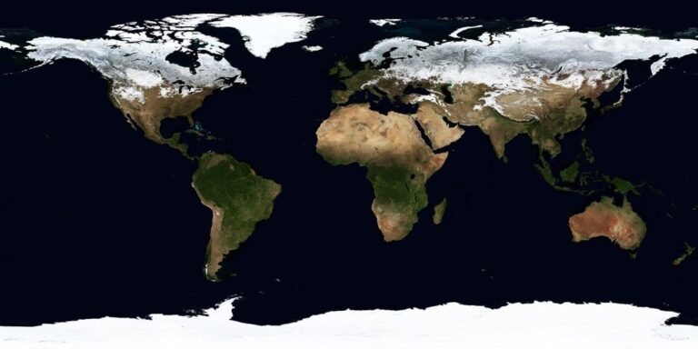
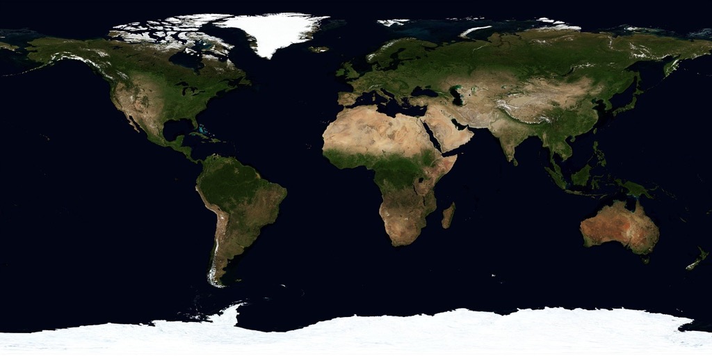
Traditional contour mapping relies on surveyor theodolites and manual field measurements to establish elevation points. You’ll typically spend weeks collecting data across terrain using total stations and GPS units. This method requires extensive fieldwork where you physically traverse the landscape to gather topographic information. The process involves plotting individual points on paper maps and hand-drawing contour lines between elevation markers. Manual interpolation between measured points often introduces human error and inconsistencies in your final maps.
P.S. check out Udemy’s GIS, Mapping & Remote Sensing courses on sale here…

Why Alternative Techniques Matter
Alternative mapping techniques deliver survey-grade accuracy in hours rather than weeks using drone photogrammetry and LiDAR sensors. You’ll reduce field time by 80% while achieving centimeter-level precision across large areas. These methods capture millions of elevation points automatically through aerial platforms and satellite imagery. Digital processing eliminates manual interpretation errors and provides consistent results across your entire project area. Cost savings become significant when you factor in reduced labor hours and equipment rental fees for extensive surveying projects.
Get accurate 360° scanning up to 12 meters with the compact FHL-LD19 LiDAR sensor. Resistant to bright light and weighing under 50g, it offers easy integration with ROS/ROS2/C/C++ SDK for robots and drones.

Digital Elevation Model (DEM) Based Contour Generation
DEM-based contour generation transforms raw elevation data into precise topographic lines using automated processing algorithms. This technique eliminates the time-intensive manual interpretation required in traditional surveying methods.
Automated Contour Creation Process
Automated contour creation processes elevation data through interpolation algorithms that calculate smooth lines connecting points of equal elevation. You’ll input your DEM file into specialized software that analyzes elevation values across a grid system. The software automatically generates contour lines at specified intervals, typically every 1-10 feet depending on your project scale. Modern algorithms apply smoothing filters to eliminate jagged edges while maintaining topographic accuracy, producing publication-ready contours in minutes rather than hours.
Software Tools and Applications
Software tools for DEM-based contouring range from open-source options like QGIS and GRASS GIS to professional platforms including ArcGIS Pro and Global Mapper. You can process elevation data from sources like USGS 3DEP datasets, drone surveys, or LiDAR collections. Many tools offer batch processing capabilities for large projects, allowing you to generate contours across multiple map sheets simultaneously. Cloud-based platforms like ArcGIS Online enable real-time collaboration and instant sharing of contour maps with project stakeholders.
LiDAR Point Cloud Contour Mapping
LiDAR technology captures millions of elevation points per second using laser pulses, creating dense three-dimensional datasets that surpass traditional surveying methods in both speed and accuracy. You’ll achieve centimeter-level precision across vast areas with this advanced remote sensing approach.
High-Precision Elevation Data Collection
LiDAR sensors emit up to 400,000 laser pulses per second, recording precise X, Y, and Z coordinates for each return point. You’ll capture elevation data with vertical accuracy ranging from 2-15 centimeters depending on flight altitude and terrain conditions. Airborne LiDAR systems like the Leica ALS80 collect point densities exceeding 15 points per square meter, while terrestrial scanners achieve sub-centimeter accuracy for detailed site analysis.
Processing Point Clouds for Contour Lines
Point cloud processing software like CloudCompare and Bentley Descartes converts raw LiDAR data into Digital Terrain Models through automated filtering algorithms. You’ll use ground classification tools to separate terrain points from vegetation and structures, then apply Triangulated Irregular Network interpolation to generate smooth elevation surfaces. Most software packages export contour lines directly from processed point clouds at user-defined intervals, maintaining the original dataset’s precision throughout the conversion process.
Photogrammetric Contour Extraction
Photogrammetric contour extraction transforms overlapping aerial photographs into precise elevation models through sophisticated computer vision algorithms. This technique generates topographic contours by analyzing stereoscopic image pairs to calculate depth and height variations across terrain surfaces.
Stereo Image Analysis Methods
Stereo photogrammetry creates three-dimensional terrain models by comparing corresponding points between overlapping aerial photographs. You’ll process image pairs using digital photogrammetric workstations like SOCET SET or Trimble INPHO, which automatically identify matching features and calculate elevation differences. Modern software applies dense matching algorithms that analyze thousands of points per square meter, producing elevation accuracies within 10-30 centimeters for typical aerial surveys.
Stay organized with this 48-inch workbench featuring drawers, shelves, and a pegboard. The enamel-coated work surface supports up to 220 pounds and includes built-in power outlets and a fluorescent light.
Drone-Based Photogrammetry Applications
Drone photogrammetry delivers rapid contour mapping for smaller project areas using consumer-grade UAVs equipped with high-resolution cameras. You can capture overlapping images at 80% forward and 60% side overlap, then process them through Structure-from-Motion software like Pix4D or Agisoft Metashape. These platforms generate dense point clouds and digital surface models within hours, enabling contour extraction at intervals as fine as 0.5 meters for construction sites and environmental studies.
Capture stunning photos and videos with this 4K 64MP digital camera. Features include a 180° flip screen for easy vlogging and built-in WiFi for seamless sharing.

GPS and RTK Survey Contour Mapping
GPS and RTK survey methods deliver centimeter-level accuracy for contour mapping projects requiring survey-grade precision. You’ll achieve real-time positioning corrections that eliminate atmospheric delays and satellite orbit errors affecting standard GPS measurements.
Real-Time Kinematic Positioning
RTK positioning uses base station corrections transmitted to your rover receiver for real-time accuracy improvements. You’ll establish a known reference point within 10 kilometers of your survey area to broadcast differential corrections via radio or cellular networks. Modern RTK systems like Trimble R12i and Leica GS18 T achieve horizontal accuracy of 8mm + 1ppm and vertical accuracy of 15mm + 1ppm. Your rover unit receives correction data continuously, eliminating post-processing requirements and enabling immediate field verification of elevation measurements.
Effortlessly maintain your lawn with the Sunseeker X7 robot mower. It uses smart app control and RTK-GNSS for precise, wireless navigation and features dual blades for efficient cutting on yards up to 0.75 acres.

Field Data Collection Techniques
Field data collection combines systematic point sampling with strategic breakline identification for comprehensive terrain modeling. You’ll establish survey control points using static GPS observations for 30-60 minutes to create your local coordinate framework. Walk systematic grid patterns or follow natural terrain features while collecting elevation points every 25-50 feet depending on terrain complexity. Modern data collectors like Trimble TSC7 or Carlson RT4 integrate RTK positioning with field coding software, allowing you to classify points as spot elevations, breaklines, or feature boundaries during collection for streamlined contour generation.
Power your Trimble TSC7 data collector with this reliable 3100mAh replacement battery. It's built to original specifications with safety certifications and a fully decoded chip for seamless performance.

Interpolation-Based Contour Generation
Interpolation algorithms transform scattered elevation measurements into continuous surface models, creating smooth contour lines from irregular point distributions. These mathematical methods estimate elevation values at unmeasured locations using spatial relationships between known data points.
Kriging and Spline Methods
Kriging techniques provide optimal interpolation by analyzing spatial correlation patterns within your elevation dataset. This geostatistical method weights nearby points based on their distance and directional relationships, producing accurate contours with quantified uncertainty estimates. Spline interpolation creates mathematically smooth surfaces by fitting curved functions through control points, generating contour lines that appear natural and eliminate artificial angular artifacts. Software like ArcGIS Pro and Surfer implement both methods with customizable parameters for different terrain types.
Grid-Based Interpolation Approaches
Grid-based methods convert irregular point data into regular matrix formats, enabling systematic contour generation across your study area. Inverse Distance Weighting (IDW) calculates cell values using nearby points with exponential decay functions, while Triangulated Irregular Networks (TIN) create contours along triangle edges formed by Delaunay triangulation. Natural neighbor interpolation preserves local data characteristics without extrapolation beyond the convex hull of input points. QGIS and Global Mapper offer these algorithms with adjustable grid resolution and smoothing parameters.
Machine Learning Enhanced Contour Detection
Machine learning algorithms now enable automated contour extraction from satellite imagery and elevation datasets with minimal human intervention. These AI-driven approaches process complex terrain patterns that traditional interpolation methods often struggle to interpret accurately.
AI-Powered Terrain Analysis
AI algorithms analyze elevation patterns to identify natural terrain features and breaklines that significantly impact contour accuracy. Machine learning models trained on thousands of topographic datasets can detect subtle elevation changes, ridge lines, and drainage patterns that human operators might miss during manual digitization.
Supervised learning techniques use labeled training data to teach algorithms how to distinguish between true terrain features and data noise. Popular frameworks like TensorFlow and PyTorch enable you to build custom terrain classification models that adapt to specific geographic regions and vegetation types.
Neural Network Applications
Convolutional neural networks (CNNs) excel at processing raster elevation data by recognizing spatial patterns across grid cells. These networks can automatically identify terrain discontinuities, water bodies, and man-made structures that require special contour handling during the mapping process.
Deep learning models integrated into GIS software like ESRI’s ArcGIS Pro now offer automated feature extraction tools that generate contours directly from raw imagery. These neural networks achieve 85-95% accuracy rates when processing high-resolution Digital Surface Models, significantly reducing manual editing time.
Conclusion
These six alternative contour mapping techniques represent a significant shift in how you approach topographic surveying. You’ll find that each method offers unique advantages depending on your project requirements budget and timeline constraints.
The technology landscape continues evolving rapidly with AI and machine learning integration becoming increasingly sophisticated. You can expect even greater automation and accuracy improvements in the coming years.
Your choice of technique should align with your specific project needs. Whether you’re working on large-scale infrastructure development or detailed environmental studies these modern approaches will help you deliver superior results while reducing both time and costs.
The future of contour mapping lies in combining multiple techniques for optimal outcomes. You’ll achieve the best results by understanding each method’s strengths and applying them strategically to your surveying challenges.
Frequently Asked Questions
What are the main limitations of traditional contour mapping methods?
Traditional contour mapping relies on manual field measurements and can take weeks to gather data. This method is time-intensive, prone to human error, and inconsistent in results. Modern techniques address these issues by providing survey-grade accuracy in hours rather than weeks, significantly reducing field time and associated costs while improving precision.
How does drone photogrammetry improve contour mapping efficiency?
Drone photogrammetry uses consumer-grade UAVs equipped with high-resolution cameras to rapidly map smaller project areas. This technique generates dense point clouds and digital surface models within hours, enabling contour extraction at fine intervals. It’s particularly effective for construction planning and environmental monitoring applications.
What accuracy levels can LiDAR point cloud mapping achieve?
LiDAR sensors can achieve vertical accuracy ranging from 2-15 centimeters, depending on flight altitude and terrain conditions. The technology captures millions of elevation points per second using laser pulses, creating dense three-dimensional datasets that surpass traditional surveying methods in both speed and precision.
What is Digital Elevation Model (DEM) based contour generation?
DEM-based contour generation transforms raw elevation data into precise topographic lines through automated processing algorithms. This method eliminates time-intensive manual interpretation and can produce publication-ready contours in minutes using interpolation algorithms to generate smooth contour lines at specified intervals.
How accurate is GPS/RTK surveying for contour mapping?
GPS/RTK surveying delivers centimeter-level accuracy with horizontal precision of 8mm + 1ppm and vertical accuracy of 15mm + 1ppm. RTK positioning uses base station corrections transmitted to rover receivers for real-time accuracy improvements, making it ideal for projects requiring survey-grade precision.
What software tools are available for modern contour mapping?
Popular software options range from open-source tools like QGIS to professional platforms like ArcGIS Pro, Surfer, and Global Mapper. These tools facilitate batch processing, real-time collaboration for large projects, and implement various interpolation methods including Kriging, Spline, IDW, and TIN with customizable parameters.
How does machine learning enhance contour detection?
Machine learning algorithms automate contour extraction from satellite imagery and elevation datasets with minimal human intervention. Using supervised learning techniques and frameworks like TensorFlow and PyTorch, these AI-driven systems analyze elevation patterns to identify terrain features and breaklines, significantly reducing manual editing time.
What are the main interpolation methods used in contour generation?
Key interpolation methods include Kriging (analyzes spatial correlation patterns), Spline (fits curved functions through control points), Inverse Distance Weighting (IDW), and Triangulated Irregular Networks (TIN). These algorithms transform scattered elevation measurements into continuous surface models for smooth contour line creation.