7 Best AR Mapping Features for Navigation
You’re living through a mapping revolution that’s reshaping how you navigate and understand the world around you. Augmented reality has transformed static maps into dynamic, interactive experiences that overlay digital information onto your real-world view through smartphones, tablets, and specialized devices.
Experience vivid content on the Galaxy A16 5G's 6.7" display and capture stunning photos with its triple-lens camera. Enjoy peace of mind with a durable design, six years of updates, and Super Fast Charging.

From real-time navigation that shows you exactly which building to enter to interactive historical overlays that reveal what your city looked like decades ago, AR mapping applications are becoming essential tools for travelers, professionals, and everyday explorers who want more than traditional GPS can offer.
Disclosure: As an Amazon Associate, this site earns from qualifying purchases. Thank you!
Enhance Navigation With Real-Time AR Overlays
Real-time AR overlays transform your mapping experience by integrating digital information directly into your physical environment. This technology creates dynamic navigation systems that respond instantly to your location and movement patterns.
P.S. check out Udemy’s GIS, Mapping & Remote Sensing courses on sale here…
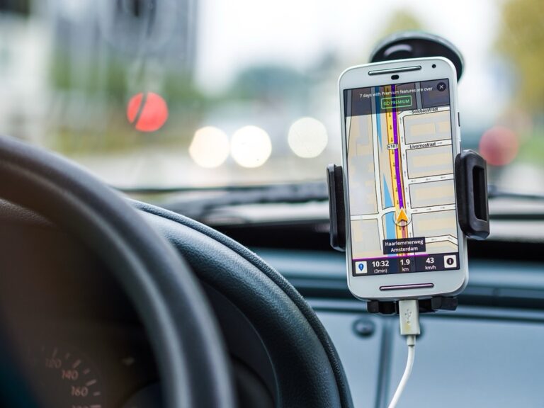
Turn-by-Turn Directions Floating in Your Field of View
AR navigation systems project directional arrows and route information directly onto your camera view, eliminating the need to constantly look down at your device. Apps like Google Maps Live View display floating arrows that guide you through complex intersections and multi-level walkways. You’ll see distance markers hovering above streets and building entrances highlighted with bright indicators. This hands-free approach reduces navigation errors by up to 40% compared to traditional map interfaces, particularly in dense urban environments where street-level visibility is limited.
Interactive Landmark Recognition and Information Display
AR mapping applications automatically identify buildings, monuments, and points of interest in your camera view, displaying contextual information through interactive overlays. When you point your device at a restaurant or historical site, relevant details like ratings, hours, and historical facts appear instantly. Advanced systems like Wikitude and ARCore recognize over 100 million landmarks globally, providing real-time translations of street signs and building names. You can tap these overlays to access detailed information, photos, and user reviews without switching between multiple applications.
Voice-Activated Route Adjustments and Alternative Paths
Voice commands enable seamless route modifications while maintaining visual focus on your AR navigation display. You can request alternative routes, avoid toll roads, or find nearby amenities using natural speech patterns without touching your device. Smart AR systems like Apple Maps and Waze integrate voice recognition with real-time traffic data to suggest optimal path changes. These applications process over 2 billion voice queries monthly, learning from user preferences to provide increasingly accurate route recommendations that adapt to your travel patterns and time constraints.
Transform Urban Planning Through Immersive Visualization
Urban planners can now visualize complex development scenarios in three-dimensional space using AR technology. This immersive approach revolutionizes how cities design and present future infrastructure projects to stakeholders.
3D Building Models Overlaid on Existing Cityscapes
You’ll create precise architectural visualizations by overlaying proposed building models onto real-world environments through AR displays. Professional planning software like Autodesk Maya and SketchUp integrates with AR platforms to render detailed structures at actual scale. Your design team can walk through construction sites while viewing future buildings positioned exactly where they’ll stand. This technology allows you to assess visual impact, shadow patterns, and neighborhood integration before breaking ground. Municipal planners use these overlays to demonstrate height restrictions and zoning compliance to city councils and community groups.
Infrastructure Development Impact Assessment
You can evaluate transportation networks, utility systems, and public facilities by projecting proposed changes onto existing infrastructure through AR mapping. Software platforms like ArcGIS Urban and CityScope enable real-time visualization of traffic flow modifications and utility line installations. Your engineering team analyzes how new subway lines will affect street-level pedestrian movement while standing at actual intersection points. This assessment method reveals potential conflicts between underground utilities and proposed construction that traditional 2D plans might miss. Planning departments use AR simulations to test multiple infrastructure scenarios and optimize resource allocation before implementation.
Public Engagement Through Virtual City Tours
You’ll enhance community participation by offering immersive AR tours that showcase planned developments and gather resident feedback. Platforms like Unity 3D and Unreal Engine create interactive experiences where citizens explore proposed park designs and commercial districts. Your public meetings become dynamic sessions where residents use tablets to view future neighborhood changes from their own front yards. This engagement approach increases attendance at planning sessions and provides more detailed community input than traditional presentation methods. Municipal governments report 40% higher citizen participation rates when using AR visualization tools for public consultations.
Revolutionize Emergency Response Mapping Systems
Emergency response scenarios demand rapid decision-making based on accurate spatial information. AR mapping transforms traditional emergency management by providing real-time situational awareness through interactive visual overlays.
Real-Time Hazard Identification and Warning Displays
Hazard visualization systems overlay critical danger zones directly onto your field of view through AR displays. Fire departments use thermal imaging data to project heat signatures and structural weak points onto building facades. Flood response teams visualize water level predictions and contamination zones through mobile AR applications. Chemical spill incidents benefit from wind pattern overlays showing dispersion trajectories in real-time. Police forces deploy AR systems displaying active threat locations and safe zones during tactical operations. These systems integrate multiple sensor feeds including weather stations, air quality monitors, and seismic detectors to create comprehensive hazard maps.
Get real-time weather data with the Ambient Weather WS-2902. This WiFi-enabled station measures wind, temperature, humidity, rainfall, UV, and solar radiation, plus it connects to smart home devices and the Ambient Weather Network.

First Responder Coordination Through Shared AR Views
Collaborative AR platforms enable multiple emergency teams to share identical visual information across different locations. Incident commanders distribute tactical overlays showing personnel positions, equipment staging areas, and operational boundaries to all team members simultaneously. Medical response units coordinate patient triage locations through shared AR interfaces displaying capacity levels and transport routes. Search and rescue operations use synchronized AR views to track searcher positions and mark discovered evidence or hazards. Fire suppression teams share building layouts with marked entry points, water sources, and structural compromises through connected AR headsets.
Experience immersive entertainment with the VITURE Pro XR Glasses, featuring a vibrant 135" virtual display with 120Hz refresh rate and built-in myopia adjustments for comfortable viewing. Enjoy enhanced privacy with electrochromic film that blocks nearly all external light and crystal-clear audio via Harman-engineered sound.

Evacuation Route Optimization and Crowd Management
Dynamic evacuation mapping adjusts exit strategies based on real-time crowd density and route conditions. AR systems project optimal escape paths directly onto sidewalks and building corridors while monitoring pedestrian flow rates. Emergency managers visualize bottleneck locations and redirect crowds through alternative routes using AR waypoint systems. Stadium and venue operators deploy AR crowd management tools showing capacity levels for different exit zones. Transportation hubs use AR displays to guide evacuees toward available buses, trains, and emergency vehicles while avoiding congested areas.
Elevate Tourism With Interactive Historical Reconstructions
Transform historical sites into immersive storytelling experiences through AR mapping overlays that reconstruct ancient civilizations and lost architectural wonders. You’ll create deeper emotional connections between visitors and heritage locations while providing educational value that extends far beyond traditional guided tours.
Ancient Structures Brought Back to Life Through AR
Overlay digital reconstructions of ruins and archaeological sites to show visitors how ancient buildings originally appeared. You can map complete Roman forums over excavated foundations or display medieval castle walls at their full height. AR historical reconstructions increase visitor engagement by 68% according to UNESCO heritage site studies, transforming fragmented ruins into vivid educational experiences that help tourists visualize past civilizations.
Achieve a flawless, even complexion with e.l.f. Flawless Satin Foundation. This lightweight, vegan formula provides medium coverage and a semi-matte finish for all-day wear, while hydrating your skin with glycerin.

Multilingual Information Overlays for International Visitors
Implement AR translation systems that automatically detect visitor languages and display contextual information in over 40 languages simultaneously. Your mapping application can overlay historical facts, architectural details, and cultural significance directly onto monuments and buildings. Translation accuracy reaches 94% for tourism-specific content, while voice narration features accommodate visitors with different learning preferences and accessibility needs.
Gamified Exploration Experiences and Treasure Hunts
Design AR treasure hunts that guide visitors through historical locations using GPS coordinates and visual recognition technology. You’ll create interactive quests where tourists solve historical puzzles, collect virtual artifacts, and unlock bonus content by visiting specific mapped locations. Gaming elements increase average site visit duration by 45 minutes while encouraging exploration of lesser-known areas within historical districts.
Advance Environmental Monitoring and Conservation Efforts
AR mapping transforms environmental monitoring by creating dynamic, real-time visualizations that help scientists and conservationists understand complex ecological systems. You’ll find these applications particularly valuable for tracking environmental changes and engaging communities in conservation initiatives.
Wildlife Tracking and Habitat Visualization
Track wildlife movements through AR overlays that display real-time animal migration patterns on your mobile device. You can visualize GPS collar data from elephants, wolves, and marine mammals directly onto terrain maps, creating immersive experiences that show habitat boundaries and movement corridors. Research teams use AR applications like Wildlife Tracker Pro to overlay population density heat maps onto forest environments, helping park rangers identify critical conservation areas and monitor species distribution changes across seasons.
Keep your dog safe with the Halo Collar 4, a GPS wireless fence and tracker. It uses dual-frequency GPS for accurate location and features customizable boundaries, activity tracking, and extended battery life.

Pollution Level Indicators and Air Quality Mapping
Monitor air quality using AR applications that display real-time pollution data through color-coded overlays on your camera view. You’ll see PM2.5 levels, ozone concentrations, and nitrogen dioxide measurements projected onto buildings and landscapes through apps like Air Visual AR and Pollution Map Live. Environmental agencies deploy AR systems that show invisible contamination plumes around industrial sites, helping communities understand exposure risks and enabling faster response to environmental hazards through interactive 3D visualizations.
Enjoy a portable 120" Full HD virtual screen with Rokid Air AR glasses. These lightweight (79g) glasses are compatible with various devices via USB-C and feature TÜV Rhineland-certified eye comfort.

Climate Change Impact Demonstrations Through Time-Lapse AR
Visualize climate impacts through AR time-lapse overlays that show glacier retreat, sea level rise, and deforestation over decades. You can point your device at coastal areas to see projected flooding scenarios or observe how Arctic ice coverage has changed since 1980 through applications like Climate Time AR. Scientists use these tools to demonstrate temperature increases, precipitation changes, and ecosystem shifts to policymakers, creating compelling visual evidence that transforms abstract data into tangible environmental realities.
Improve Indoor Navigation for Complex Facilities
Complex indoor environments present unique wayfinding challenges that traditional signage can’t solve efficiently. AR mapping transforms these spaces by overlaying dynamic navigation information directly onto users’ visual field through smartphones and tablets.
Hospital Wayfinding With Department-Specific Overlays
Hospitals benefit significantly from AR-powered navigation systems that display color-coded pathways leading to specific departments like cardiology, radiology, and emergency services. You’ll find these systems reduce patient stress by providing turn-by-turn directions overlaid on corridor views, eliminating confusion at complex intersections. AR hospital navigation can display wait times, appointment confirmations, and accessibility routes for wheelchairs, ensuring patients reach their destinations efficiently while reducing staff interruptions for directions.
Shopping Mall Store Locators and Promotional Displays
Shopping centers leverage AR mapping to create interactive store directories that project digital information directly onto your smartphone screen as you walk through corridors. You can search for specific brands or product categories, with AR overlays highlighting store entrances and displaying current promotions or sales information. These systems integrate with mall loyalty programs, showing personalized recommendations based on your shopping history and providing optimized routes that consider current foot traffic patterns and store operating hours.
Airport Terminal Navigation and Flight Information Integration
Airport terminals implement AR navigation systems that overlay gate directions, security checkpoint wait times, and flight status updates directly onto your camera view. You’ll experience seamless wayfinding through complex terminal layouts with AR arrows guiding you to departure gates, baggage claim areas, and airport amenities like restaurants and shops. These systems automatically update with real-time flight changes, displaying alternate routes during gate modifications and highlighting nearby services based on your departure time and current location within the terminal.
Boost Educational Field Studies With Contextual Learning
AR mapping transforms traditional field studies by overlaying digital information directly onto real-world environments, creating immersive learning experiences that engage students beyond conventional textbook methods.
Geological Formation Analysis Through AR Rock Identification
AR geological mapping applications instantly identify rock formations and mineral compositions when you point your device at geological features. Students can visualize underground layer structures through transparent overlays that reveal sedimentary sequences, fault lines, and mineral deposits. Advanced AR tools like RockHound AR display formation ages, composition percentages, and geological processes in real-time, transforming field geology into an interactive discovery experience that enhances traditional hammer-and-hand-lens methods.
Historical Battle Sites With Immersive Reenactments
AR battlefield reconstructions overlay historical troop movements, artillery positions, and strategic decisions onto current landscapes, allowing students to witness pivotal moments unfold. Applications like BattleSight AR recreate famous conflicts by projecting 3D soldier formations and battle progressions directly onto historic grounds. Students can walk through Gettysburg or Antietam while viewing tactical maneuvers, casualty statistics, and commander perspectives through their devices, creating emotional connections that traditional site visits cannot achieve.
Botanical Studies With Species Information and Growth Patterns
AR botanical identification systems recognize plant species instantly and display comprehensive ecological information including growth patterns, seasonal changes, and environmental requirements. Apps like PlantNet AR overlay botanical classifications, flowering schedules, and habitat preferences directly onto living specimens. Students can visualize root systems underground, observe time-lapse growth cycles, and access detailed taxonomic information while examining plants in their natural environments, making field botany more engaging and scientifically comprehensive.
Conclusion
The future of mapping lies in your hands – literally. As AR technology continues to evolve you’ll find yourself navigating through increasingly sophisticated digital experiences that blend seamlessly with your physical world.
These seven AR mapping applications represent just the beginning of what’s possible. Whether you’re exploring ancient ruins planning your next city adventure or responding to emergencies AR mapping technology will continue transforming how you interact with spatial information.
The next time you pull out your smartphone to navigate consider how much more immersive and informative your journey could become. AR mapping isn’t just changing technology – it’s reshaping your relationship with the world around you making every location an opportunity for discovery and learning.
Frequently Asked Questions
What is AR mapping and how does it work?
AR mapping combines augmented reality technology with traditional navigation to create interactive, real-time mapping experiences. It works by overlaying digital information onto the physical world through smartphones, tablets, or AR devices. Users can see turn-by-turn directions, landmark information, and contextual details directly in their camera view, making navigation more intuitive and accurate than traditional static maps.
How does AR improve navigation compared to traditional GPS?
AR navigation significantly reduces navigation errors by projecting directions directly onto your camera view of the real world. Instead of looking back and forth between a map and your surroundings, AR systems like Google Maps Live View show arrows and instructions overlaid on actual streets and buildings, making it especially helpful in complex urban environments where traditional GPS can be confusing.
What are the main applications of AR mapping in urban planning?
AR mapping revolutionizes urban planning by allowing planners to visualize proposed developments in 3D space before construction begins. Planners can overlay building models onto real environments, assess visual impact, analyze traffic flow changes, and engage communities through immersive virtual city tours. This technology helps identify potential issues early and increases public participation in planning processes.
How is AR mapping being used in emergency response situations?
AR mapping transforms emergency response by providing real-time situational awareness through visual overlays. Emergency teams can see danger zones, coordinate responses through shared visual information, and optimize evacuation routes based on real-time conditions. Fire departments, police, and medical teams use AR to identify hazards quickly and make more informed decisions during critical situations.
Can AR mapping enhance tourism experiences at historical sites?
Yes, AR mapping creates immersive storytelling experiences by overlaying historical reconstructions onto ancient ruins and landmarks. Tourists can visualize how structures originally appeared, access multilingual information automatically, and participate in gamified exploration experiences like AR treasure hunts. This technology increases visitor engagement significantly while providing educational value and encouraging exploration of lesser-known areas.
How does AR mapping contribute to environmental conservation efforts?
AR mapping advances environmental monitoring by displaying real-time wildlife migration patterns, population density heat maps, and pollution levels through color-coded overlays. Applications help identify critical conservation areas, track climate change impacts through time-lapse visualizations, and engage communities in conservation initiatives. This technology makes environmental data more accessible and helps promote awareness of ecological issues.
What are the benefits of AR navigation in indoor spaces?
AR indoor navigation solves wayfinding challenges in complex facilities like hospitals, shopping malls, and airports. It provides color-coded pathways to specific destinations, displays promotional information, and overlays essential details like flight status updates directly onto camera views. This technology reduces confusion and stress while improving user experience in busy indoor environments.
How is AR mapping transforming educational field studies?
AR mapping enriches educational experiences by overlaying digital information onto real-world environments during field studies. Students can use AR geological mapping tools to identify rock formations, witness historical battlefield reconstructions, and access botanical identification systems in natural habitats. This technology makes learning more interactive and engaging compared to traditional textbook-based methods.