5 Best 3D Map Integration Methods
Why it matters: Modern mapping has evolved beyond flat representations and you’re now seeing stunning three-dimensional visualizations that transform how we navigate and understand geographic data.
The big picture: From interactive city models to terrain elevation displays 3D mapping elements create immersive experiences that make complex spatial information instantly accessible and engaging for users.
What’s ahead: You’ll discover five proven methods that developers and designers use to seamlessly integrate 3D components into digital maps — turning static geography into dynamic visual storytelling tools.
Disclosure: As an Amazon Associate, this site earns from qualifying purchases. Thank you!
P.S. check out Udemy’s GIS, Mapping & Remote Sensing courses on sale here…
Photogrammetry: Transforming Real-World Photography Into 3D Map Elements
Photogrammetry revolutionizes how you create three-dimensional map elements by extracting precise geometric data from overlapping photographs. This proven technique transforms ordinary images into detailed 3D models that integrate seamlessly with digital mapping platforms.
Aerial Photography Techniques for Accurate Terrain Mapping
Position your drone or aircraft at 300-400 feet altitude for optimal ground sampling distance when capturing terrain features. Maintain 80% forward overlap and 60% side overlap between consecutive images to ensure complete coverage. Set your camera to manual mode with consistent exposure settings across the entire flight mission. Plan your flight paths in parallel strips using automated flight planning software like DroneDeploy or Pix4Dcapture. Capture images during midday hours to minimize shadows that can distort elevation calculations. Ground control points placed every 500 meters provide essential reference data for accurate georeferencing and scale verification.
Improve drone mapping accuracy with this 10-pack of numbered (0-9) 24"x24" GCP targets. Durable, waterproof Oxford cloth with high-contrast black and white design ensures clear visibility and reliable performance in various conditions.

Ground-Level Image Capture for Building and Structure Detail
Circle each building structure completely while maintaining consistent 15-20 foot distance from walls to capture architectural details effectively. Take photographs every 10-15 degrees around the perimeter ensuring vertical overlap of building facades. Use a polarizing filter to reduce reflections from glass surfaces and water features that interfere with photogrammetric processing. Capture multiple elevation angles including ground level upward shots and elevated downward perspectives. Document entrance areas and architectural features with close-up detail shots at 3-5 foot distances. Maintain consistent ISO settings below 800 to minimize digital noise that degrades model quality during processing workflows.
Enhance colors and reduce reflections with the K&F Concept 67mm Circular Polarizer Filter. Its ultra-slim frame prevents vignetting, while multi-coated Japanese AGC glass ensures optimal image quality.

Software Processing Workflows for Converting Photos to 3D Models
Import your image datasets into Agisoft Metashape or Pix4Dmapper for professional-grade photogrammetric reconstruction workflows. Configure camera calibration parameters and enable automatic tie point detection with high accuracy settings. Generate dense point clouds with medium to high quality settings depending on your final model resolution requirements. Create mesh surfaces from point cloud data using Poisson reconstruction algorithms for smooth terrain representation. Export textured 3D models in OBJ or FBX formats compatible with mapping platforms like Cesium or ArcGIS Online. Process ground control point coordinates to achieve sub-meter horizontal accuracy for survey-grade mapping applications.
LiDAR Technology: Precision Laser Scanning for Detailed Topographic Integration
LiDAR technology represents the gold standard for capturing precise elevation data in modern cartographic workflows. You’ll find this active remote sensing method delivers unmatched accuracy for three-dimensional terrain integration across diverse mapping applications.
Airborne LiDAR Systems for Large-Scale Terrain Mapping
Airborne LiDAR platforms provide comprehensive topographic coverage at remarkable speeds across extensive geographic areas. You’ll achieve point densities of 1-15 points per square meter while maintaining vertical accuracy within 10-15 centimeters for most terrain types. Modern aircraft-mounted systems like the Leica TerrainMapper and Riegl VQ-1560i deliver consistent data quality across flight paths spanning hundreds of square kilometers. Your flight planning software calculates optimal altitude and overlap parameters to ensure complete surface coverage while minimizing data gaps.
Terrestrial LiDAR for High-Resolution Urban Environment Capture
Terrestrial LiDAR systems excel at documenting complex urban structures with millimeter-level precision through ground-based scanning stations. You’ll capture detailed building facades, infrastructure elements, and street-level features that airborne systems can’t reach effectively. Professional scanners like the Faro Focus3D and Leica RTC360 generate dense point clouds exceeding 1 million points per second. Your scanning workflow requires multiple station setups with overlapping coverage to eliminate shadow zones and ensure complete architectural documentation.
Power your FARO 3D laser scanner with this high-capacity 6750mAh replacement battery. It's certified for safety and offers overcharge/discharge protection for reliable performance.

Data Processing and Point Cloud Integration Methods
Point cloud processing transforms raw LiDAR data into usable 3D mapping elements through specialized software workflows. You’ll classify point returns into categories like ground, vegetation, buildings, and water using algorithms in platforms such as TerraSolid or Global Mapper. Your processing pipeline includes noise filtering, ground surface generation, and feature extraction to create clean Digital Elevation Models. Modern software automates much of this classification work while allowing manual refinement for complex urban environments or challenging terrain conditions.
Digital Elevation Models: Creating Realistic Height-Based Terrain Features
Digital elevation models form the foundational layer for realistic terrain visualization in 3D mapping applications. These height-based datasets provide the geometric framework that transforms flat geographic data into immersive topographic representations.
Achieve a flawless, even complexion with e.l.f. Flawless Satin Foundation. This lightweight, vegan formula provides medium coverage and a semi-matte finish for all-day wear, while hydrating your skin with glycerin.

Satellite-Derived DEM Data Sources and Applications
Satellite-based elevation data provides global coverage through multiple high-resolution sources for your mapping projects. NASA’s SRTM dataset offers 30-meter resolution worldwide, while the ASTER GDEM delivers 30-meter global coverage with improved accuracy in mountainous regions. Commercial providers like Maxar’s WorldDEM supply sub-meter precision for detailed urban and infrastructure mapping. You’ll access these datasets through platforms like USGS Earth Explorer, NASA Earthdata, or commercial GIS services. Processing workflows typically involve coordinate system conversion, datum adjustments, and quality validation to ensure seamless integration with your existing mapping frameworks.
Contour Line Conversion Techniques for 3D Visualization
Contour line interpolation transforms traditional elevation data into continuous 3D surfaces using advanced algorithmic approaches. You’ll employ spline interpolation methods to generate smooth elevation transitions between contour intervals, typically using tools like ArcGIS Spatial Analyst or QGIS interpolation plugins. Triangulated irregular networks (TINs) provide accurate representations of terrain breaks and ridgelines from your contour datasets. Natural neighbor and inverse distance weighting algorithms handle irregular contour spacing effectively. Professional workflows include validation against known elevation points, edge matching between map sheets, and density optimization to balance file size with terrain accuracy requirements.
Mesh Generation and Smoothing Algorithms for Natural Landscapes
Mesh optimization algorithms create natural-looking terrain surfaces from raw elevation data through systematic geometric processing. You’ll apply Laplacian smoothing to eliminate artifacts while preserving essential topographic features like ridges and valleys. Delaunay triangulation generates optimal mesh connectivity for irregular elevation datasets. Advanced techniques include feature-preserving smoothing that maintains sharp terrain breaks and adaptive mesh refinement for variable detail levels. Tools like MeshLab, Blender’s geometry nodes, or specialized GIS software handle complex mesh operations. Quality control involves slope analysis, aspect verification, and visual inspection to ensure your terrain models accurately represent natural landscape characteristics.
Manual 3D Modeling: Custom Asset Creation for Unique Map Features
Manual 3D modeling gives you complete creative control over specialized map elements that automated capture methods can’t provide. You’ll create custom assets tailored to your specific cartographic requirements.
CAD Software Integration for Architectural Elements
Create professional designs with BeckerCAD 15 3D PRO, compatible with AutoCAD. Import/export DWG/DXF files and visualize your projects in realistic 3D.

CAD software integration transforms architectural blueprints into precise 3D map components for complex building visualization. You’ll import AutoCAD DWG files directly into mapping platforms like ArcGIS Pro or QGIS, maintaining accurate dimensional relationships and layered structure information. Autodesk AutoCAD and SketchUp Pro offer robust georeferencing tools that align architectural models with coordinate systems. Professional workflows typically involve exporting models as CityGML or 3D Tiles formats for seamless web map integration.
Procedural Generation Tools for Repetitive Structures
Procedural generation tools automate the creation of repetitive urban infrastructure elements like street furniture and utility poles. Houdini and Blender’s Geometry Nodes excel at generating parametric models based on rules you define for specific map areas. You’ll establish templates for lamp posts, traffic signals, and building facades that automatically populate along street networks. These tools reduce modeling time by 80% while maintaining consistent visual quality across large-scale mapping projects.
Texture Mapping and Material Application for Realistic Rendering
Texture mapping and material application transform basic 3D geometry into photorealistic map elements that enhance spatial understanding. You’ll apply high-resolution facade textures using Substance Painter or 3ds Max, ensuring UV coordinates align properly with building surfaces. PBR materials (Physically Based Rendering) provide accurate light interaction for different surface types like concrete, glass, and vegetation. Quality texture resolution should match your map’s zoom levels—typically 1024×1024 pixels for city-scale visualization and 2048×2048 for detailed architectural features.
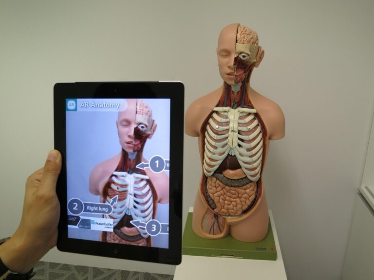
Augmented Reality Overlays: Interactive 3D Elements for Enhanced User Experience
Augmented reality transforms traditional mapping by overlaying dynamic 3D elements onto real-world environments through mobile devices and specialized hardware. This integration creates immersive navigation experiences that bridge digital cartographic data with physical spaces.
GPS-Based Positioning for Accurate 3D Object Placement
GPS positioning anchors 3D map elements to precise geographic coordinates using differential correction techniques. You’ll achieve centimeter-level accuracy by combining RTK (Real-Time Kinematic) corrections with IMU (Inertial Measurement Unit) sensors that compensate for device orientation changes. Professional AR mapping applications like Esri’s ArcGIS Field Maps utilize WAAS (Wide Area Augmentation System) corrections to maintain consistent object placement within 1-3 meter accuracy ranges. Coordinate transformation algorithms convert WGS84 positions into local reference frames, ensuring 3D elements remain stable during user movement and device rotation.
Real-Time Rendering Techniques for Mobile Devices
Real-time rendering optimizes 3D map elements for mobile hardware constraints through level-of-detail (LOD) algorithms and occlusion culling. You’ll implement frustum culling to render only visible geometry, reducing processing overhead by 40-60% in complex urban environments. Graphics APIs like Metal (iOS) and Vulkan (Android) provide low-level access to GPU resources, enabling 60fps performance for textured 3D buildings and terrain meshes. Texture streaming and progressive mesh loading techniques manage memory consumption, allowing devices with 4GB RAM to display detailed city models spanning several square kilometers without performance degradation.
User Interface Design for Seamless AR Map Navigation
User interface design balances information density with spatial awareness through context-sensitive controls and gesture-based interactions. You’ll position UI elements outside the central field of view to prevent occlusion of important 3D map features, typically placing controls in the lower 20% of screen space. Touch gestures like pinch-to-zoom and two-finger rotation manipulate 3D map perspectives while maintaining GPS tracking accuracy. Visual feedback systems use color-coded waypoints and distance indicators that scale dynamically based on user proximity, ensuring navigation cues remain visible at distances ranging from 10 meters to 2 kilometers.
Track vehicles and assets with the LandAirSea 54 GPS Tracker. Get real-time location alerts and historical playback using the SilverCloud app, with a long-lasting battery and discreet magnetic mount.

Conclusion
These five integration methods give you powerful tools to transform your mapping projects from basic 2D displays into engaging three-dimensional experiences. Whether you’re leveraging photogrammetry’s precision or AR’s immersive capabilities you’ll find the right approach for your specific needs and technical requirements.
The key to successful 3D map integration lies in matching your chosen method to your project’s scope budget and desired level of detail. Start with one technique that aligns with your current resources then gradually expand your toolkit as you gain experience.
Your users will appreciate the enhanced spatial understanding and visual appeal that 3D elements bring to your maps. The investment in these technologies pays dividends through improved user engagement and more effective data communication.
Frequently Asked Questions
What is 3D mapping and how does it differ from traditional maps?
3D mapping creates three-dimensional visualizations of geographic areas, displaying terrain elevation, building heights, and spatial relationships in a realistic way. Unlike traditional flat maps, 3D mapping provides immersive, interactive experiences that make complex spatial information more accessible and engaging for navigation and geographic understanding.
What is photogrammetry and how is it used in 3D mapping?
Photogrammetry creates 3D map elements by extracting geometric data from overlapping photographs. This method uses aerial photography for terrain mapping and ground-level capture for building details. Special software then processes these images to generate accurate, georeferenced 3D models suitable for various mapping platforms.
How does LiDAR technology work for creating 3D maps?
LiDAR (Light Detection and Ranging) uses laser pulses to measure precise distances and create detailed point clouds of terrain and structures. Airborne LiDAR systems provide extensive topographic coverage, while terrestrial scanners document urban structures with millimeter-level precision. The data is then processed into usable 3D mapping elements.
What are Digital Elevation Models (DEMs) in 3D mapping?
Digital Elevation Models are foundational datasets that represent terrain elevation across geographic areas. They use satellite-derived data like NASA’s SRTM and convert contour lines into continuous 3D surfaces. DEMs provide the base layer for realistic terrain visualization in 3D mapping applications.
Can I create custom 3D map elements manually?
Yes, manual 3D modeling allows creation of custom assets for specific mapping needs. This involves using CAD software to transform blueprints into 3D components, employing procedural generation tools for repetitive elements, and applying texture mapping techniques to enhance realism and visual quality.
How does augmented reality enhance 3D mapping?
Augmented reality overlays dynamic 3D elements onto real-world environments through your device’s camera. It uses GPS positioning for accurate object placement and real-time rendering optimized for mobile devices, creating immersive navigation experiences that blend digital map information with the physical world.
What software is needed for 3D mapping workflows?
3D mapping requires specialized software for different processes: photogrammetry software for image processing, LiDAR processing tools for point cloud data, CAD programs for manual modeling, and AR development platforms for mobile applications. The choice depends on your specific mapping method and project requirements.
How accurate are 3D mapping technologies?
Accuracy varies by technology: LiDAR can achieve millimeter-level precision for terrestrial scanning and centimeter accuracy for airborne systems. Photogrammetry typically provides centimeter to meter-level accuracy depending on image quality and processing methods. Professional-grade equipment and proper workflows ensure the highest accuracy levels.