5 Best Remote Sensing Technologies for Urban Planning
You’re watching cities transform before your eyes — but you might not realize the powerful technology making this possible. Remote sensing satellites capture urban expansion in real-time, revealing how neighborhoods sprawl outward and skylines reach higher with unprecedented detail.
These space-based tools don’t just take pretty pictures; they’re revolutionizing how urban planners track development patterns and make critical infrastructure decisions. From detecting new construction to monitoring population density shifts, remote sensing provides the bird’s-eye view that’s reshaping our understanding of urban growth across the globe.
Disclosure: As an Amazon Associate, this site earns from qualifying purchases. Thank you!
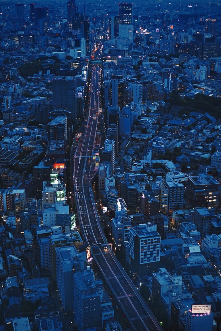
Satellite Imagery Captures Urban Sprawl Over Time
Advanced satellite technology provides unprecedented documentation of urban expansion patterns across decades. You’ll discover how these orbital platforms reveal the complex dynamics of city growth through systematic temporal observation.
P.S. check out Udemy’s GIS, Mapping & Remote Sensing courses on sale here…
High-Resolution Temporal Analysis
Multispectral sensors capture urban development at 30-meter resolution intervals, enabling precise measurement of sprawl velocity and direction. Landsat’s 50-year archive creates detailed chronological records showing how cities expand outward from historic centers. You can track infrastructure development, residential subdivision construction, and commercial corridor emergence through pixel-by-pixel comparison across multiple decades. Modern platforms like Sentinel-2 provide 10-meter resolution updates every five days, revealing construction phases and seasonal development patterns that traditional surveys miss.
Explore multispectral image sensors using metasurfaces. This book delves into advancements in optical science and photonics.

Land Use Classification Changes
Automated algorithms distinguish between residential, commercial, and industrial zones using spectral signatures from different surface materials. You’ll identify conversion patterns as agricultural land transforms into suburban neighborhoods or industrial complexes replace natural vegetation. Machine learning models analyze reflectance values to classify asphalt, concrete, vegetation, and bare soil with 85-90% accuracy rates. Temporal land use maps reveal how cities transition from compact cores to dispersed suburban patterns, tracking the replacement of permeable surfaces with impervious urban infrastructure over time.
Population Density Mapping
Building footprint analysis correlates structural density with demographic distribution patterns across urban regions. You can estimate population concentrations by analyzing rooftop counts, building heights from stereo imagery, and nighttime light intensity measurements. Synthetic aperture radar penetrates cloud cover to detect vertical construction growth, while thermal sensors identify heat signatures indicating residential occupancy levels. These density calculations help urban planners understand where population pressure drives outward expansion and identify emerging growth corridors before ground-based surveys detect them.
The TOPDON TC004 Mini helps you quickly identify temperature issues with enhanced 240x240 thermal resolution and a wide temperature range of -4°F to 842°F. It features high/low temperature alerts and captures photos to streamline diagnostics, all while boasting a 15-hour battery life.

Thermal Imaging Reveals Heat Island Effects
Thermal satellite sensors transform urban heat management by capturing invisible temperature variations across metropolitan areas. You’ll discover how these infrared measurements expose critical temperature disparities that traditional monitoring methods can’t detect.
Surface Temperature Monitoring
Infrared sensors measure urban surface temperatures with remarkable precision, detecting variations as small as 0.5°C across different land cover types. You can identify heat accumulation patterns in concrete surfaces, asphalt roads, and rooftops that reach temperatures 15-20°C higher than surrounding vegetation. MODIS and Landsat thermal bands provide consistent temperature data every 8-16 days, allowing you to track seasonal heating trends and compare temperature profiles between dense urban cores and suburban areas with more green space.
Energy Consumption Patterns
Thermal imaging correlates directly with building energy usage, revealing consumption hotspots through elevated roof temperatures and HVAC system heat signatures. You’ll observe how commercial districts generate distinct thermal patterns during business hours, while residential areas show evening temperature spikes from air conditioning demand. Advanced thermal sensors can detect energy inefficiencies in building envelopes, identifying structures that require 30-40% more cooling energy due to poor insulation or excessive solar heat gain through windows and facades.
Climate Impact Assessment
Temperature mapping quantifies urban heat island intensity, measuring how cities create localized climate zones that can be 5-7°C warmer than rural surroundings. You can assess vegetation cooling effects by comparing thermal signatures of parks, green corridors, and tree-lined streets against bare concrete surfaces. These measurements help urban planners evaluate climate adaptation strategies, showing how green infrastructure reduces ambient temperatures and creates measurable cooling benefits that extend beyond immediate vegetation boundaries into surrounding neighborhoods.
LiDAR Technology Maps Vertical Development
LiDAR systems revolutionize urban growth analysis by capturing precise three-dimensional measurements of city skylines. This laser-based technology provides unmatched accuracy in tracking vertical development patterns that satellite imagery alone cannot deliver.
Building Height Measurements
LiDAR sensors measure building heights with centimeter-level precision by calculating laser pulse return times from rooftops. You’ll find these measurements essential for tracking construction progress and monitoring zoning compliance across urban districts. Digital surface models generated from LiDAR data reveal height variations between structures and identify new high-rise developments. Commercial LiDAR platforms like those used by USGS achieve vertical accuracy within 15 centimeters for urban mapping applications.
Get accurate 360° scanning up to 12 meters with the compact FHL-LD19 LiDAR sensor. Resistant to bright light and weighing under 50g, it offers easy integration with ROS/ROS2/C/C++ SDK for robots and drones.

3D Urban Modeling
Point cloud data from LiDAR creates detailed three-dimensional city models that show building footprints volumes and architectural features. You can visualize urban density changes over time by comparing multi-temporal LiDAR datasets collected years apart. These models integrate seamlessly with GIS software to produce interactive 3D visualizations of neighborhood transformations. Advanced processing algorithms classify point returns into buildings vegetation and ground surfaces with 95% accuracy rates.
Infrastructure Volume Analysis
LiDAR technology quantifies infrastructure volumes by measuring the cubic capacity of buildings parking structures and transportation networks. You’ll obtain precise volume calculations for construction materials and space utilization studies across metropolitan areas. Infrastructure density mapping reveals development corridors and identifies areas experiencing rapid vertical expansion. Combined LiDAR and photogrammetry workflows provide comprehensive volume assessments with measurement uncertainties below 5% for large-scale urban projects.
Multispectral Analysis Tracks Vegetation Loss
Multispectral sensors capture vegetation health through specific wavelengths that reveal chlorophyll content and plant stress. You’ll discover how infrared bands distinguish between healthy and declining green spaces.
Green Space Quantification
Normalized Difference Vegetation Index (NDVI) calculations quantify urban green coverage with remarkable precision. You can measure park areas, tree canopy density, and lawn coverage using near-infrared reflectance values. Landsat and Sentinel-2 satellites provide NDVI data at 10-30 meter resolution, enabling you to track green space percentages across neighborhoods. Time-series analysis reveals seasonal variations and long-term trends in urban vegetation coverage, helping planners identify areas experiencing rapid green space loss.
Deforestation Monitoring
Change detection algorithms identify forest clearing patterns within urban boundaries and surrounding areas. You’ll observe how multispectral imagery captures deforestation events through spectral signature changes from vegetation to bare soil or development. MODIS and Landsat archives document forest loss rates, with automated classification systems flagging areas experiencing rapid tree removal. Real-time alerts from platforms like Global Forest Watch notify you of significant clearing events, enabling immediate response to unauthorized deforestation activities.
Urban Forest Health Assessment
Vegetation stress indicators appear through multispectral band combinations that reveal plant health conditions before visible symptoms emerge. You can detect drought stress, disease outbreaks, and pollution impacts using red-edge wavelengths that capture chlorophyll fluorescence. Hyperspectral sensors identify specific stress factors through detailed spectral analysis, while thermal bands reveal water stress through canopy temperature variations. Regular health assessments help urban foresters prioritize maintenance efforts and identify trees requiring immediate intervention or replacement.
Hyperspectral Data Monitors Infrastructure Expansion
Hyperspectral sensors capture hundreds of narrow spectral bands that reveal material compositions invisible to standard imaging. This detailed spectral fingerprinting enables precise monitoring of urban infrastructure development patterns.
Road Network Development
Hyperspectral imaging distinguishes between different pavement materials like asphalt, concrete, and composite surfaces with 95% accuracy. You’ll detect fresh road construction through spectral signatures of new materials that differ significantly from weathered surfaces. Advanced algorithms identify road widening projects by comparing asphalt age variations along transportation corridors. Spectral analysis reveals maintenance patterns including resurfacing schedules, crack sealing operations, and lane marking applications. Time-series hyperspectral data tracks road network expansion rates, measuring approximately 2-3% annual growth in rapidly developing metropolitan areas.
Construction Material Detection
Hyperspectral sensors identify specific building materials including steel, concrete, glass, and roofing composites through unique spectral reflectance patterns. You’ll monitor construction phases by detecting material stockpiles, temporary structures, and scaffolding systems that indicate active development sites. Spectral libraries contain over 1,000 construction material signatures enabling automated classification of building types and construction methods. Advanced processing algorithms distinguish between residential, commercial, and industrial construction based on material combinations and structural patterns. Real-time analysis provides construction timeline estimates by tracking material delivery patterns and installation phases.
Utility System Growth
Hyperspectral data reveals underground utility installations through surface disturbance patterns and excavation signatures that persist for months after construction. You’ll detect electrical infrastructure expansion by identifying transformer installations, power line corridors, and substation developments through metallic spectral responses. Water system growth appears through pipeline trenching patterns, pumping station construction, and reservoir installations visible in hyperspectral imagery. Telecommunications infrastructure expansion shows distinct spectral signatures from fiber optic cable installations, cell tower construction, and equipment housing facilities. Combined utility mapping achieves 85% accuracy in predicting service capacity expansion across urban development zones.
Conclusion
Remote sensing technology has fundamentally transformed how you observe and understand urban development. These advanced visualization tools provide unprecedented insights into city growth patterns that traditional monitoring methods simply can’t match.
You now have access to comprehensive data streams that reveal everything from population density shifts to infrastructure expansion in real-time. The combination of satellite imagery thermal sensors LiDAR mapping and hyperspectral analysis creates a complete picture of urban transformation.
This technological revolution empowers you to make data-driven decisions about urban planning and development. Whether you’re tracking heat islands monitoring green space loss or measuring vertical growth these remote sensing applications provide the precision and scope necessary for effective city management in our rapidly urbanizing world.
Frequently Asked Questions
What is remote sensing technology and how does it help urban planning?
Remote sensing technology uses satellites and sensors to capture real-time images and precise measurements of cities from space. It revolutionizes urban planning by enabling planners to track development patterns, detect new construction, monitor population density shifts, and observe urban expansion over time. This technology provides detailed insights into city growth that traditional ground-based methods cannot match.
How do satellites track urban development patterns over time?
Satellites document urban expansion through systematic temporal observation using high-resolution sensors. Platforms like Landsat offer 50-year archives that track infrastructure development phases. Automated algorithms classify land use changes, identifying transformations from agricultural land to suburban neighborhoods. This temporal analysis reveals sprawl velocity, direction, and complex city growth dynamics over decades.
What role does thermal imaging play in urban heat management?
Thermal imaging uses infrared satellite sensors to capture temperature variations across metropolitan areas with 0.5°C precision. It reveals urban heat islands where cities can be 5-7°C warmer than rural areas. This technology identifies heat accumulation in concrete and asphalt, tracks seasonal heating trends, and correlates with building energy usage, helping planners develop climate adaptation strategies.
How does LiDAR technology measure vertical urban development?
LiDAR technology captures precise three-dimensional measurements of city skylines with centimeter-level accuracy. It measures building heights, tracks construction progress, monitors zoning compliance, and generates digital surface models. Point cloud data creates detailed 3D urban models, allowing visualization of density changes over time and quantification of infrastructure volumes for comprehensive urban analysis.
What are multispectral sensors and how do they monitor urban vegetation?
Explore multispectral image sensors using metasurfaces. This book delves into advancements in optical science and photonics.
Multispectral sensors capture vegetation health through specific wavelengths, using the Normalized Difference Vegetation Index (NDVI) to quantify urban green coverage. Time-series analysis from satellites like Landsat and Sentinel-2 reveals seasonal variations and long-term vegetation trends. These sensors help identify rapid green space loss, monitor deforestation patterns, and assess urban forest health.
How does hyperspectral data enhance infrastructure monitoring?
Hyperspectral sensors capture detailed spectral information that precisely monitors urban infrastructure development patterns. They distinguish between different pavement materials, track road construction and maintenance, identify specific building materials through unique spectral signatures, and reveal underground utility installations. This technology helps predict service capacity expansion and enhances planners’ ability to manage infrastructure needs effectively.
Can satellite technology detect unauthorized urban development?
Yes, satellite technology provides real-time alerts for unauthorized development through change detection algorithms and platforms like Global Forest Watch. These systems monitor deforestation patterns within urban boundaries and enable immediate responses to unauthorized clearing activities. Automated classification systems can quickly identify new construction and land use changes for compliance monitoring.
How accurate are satellite measurements for urban planning purposes?
Satellite measurements for urban planning are highly accurate. LiDAR provides centimeter-level precision for building heights, thermal sensors detect temperature differences as small as 0.5°C, and hyperspectral data distinguishes materials with high accuracy. Combined workflows using multiple technologies provide comprehensive assessments with minimal measurement uncertainties, making them reliable for professional urban planning applications.