7 Best Data Sources for Digital Mapping
You’re working on a cartographic project and realize traditional datasets aren’t cutting it anymore. The usual suspects—government databases and commercial mapping services—often lack the granular detail or real-time updates your project demands.
Smart cartographers are turning to unconventional data sources that offer fresh perspectives and unprecedented accuracy. From social media geotags to satellite imagery analysis these alternative approaches can transform how you visualize spatial information and tell compelling geographic stories.
Explore and map the wilderness for the Queen in Cartographers! Draw unique terrain shapes and score points based on randomly selected goals each game, but beware of monster ambushes.

Disclosure: As an Amazon Associate, this site earns from qualifying purchases. Thank you!
Crowdsourced Geographic Data From OpenStreetMap
OpenStreetMap represents the world’s largest collaborative mapping initiative, offering cartographers access to detailed geographic data that rivals commercial alternatives. You’ll find this open-source platform particularly valuable when traditional datasets lack the granular detail your cartographic projects demand.
P.S. check out Udemy’s GIS, Mapping & Remote Sensing courses on sale here…
Community-Driven Mapping Excellence
Community volunteers contribute millions of geographic features daily through direct field surveys and satellite imagery interpretation. You can access detailed infrastructure data including building footprints, road classifications, and points of interest that government databases often overlook. Local mappers frequently provide attribute data like business hours, accessibility features, and seasonal road conditions that enhance your cartographic accuracy beyond standard commercial offerings.
Real-Time Updates and Local Knowledge
OpenStreetMap’s distributed editing system enables near-instantaneous updates when infrastructure changes occur in mapped areas. You benefit from local contributors who document construction projects, new developments, and temporary road closures within hours of their occurrence. This responsiveness proves especially valuable for emergency response mapping, urban planning projects, and navigation applications where current conditions directly impact your cartographic outcomes.
Integration Methods for Cartographic Projects
Standard APIs and data exports allow seamless integration of OpenStreetMap data into most GIS workflows and cartographic software packages. You can download regional extracts in multiple formats including Shapefile, GeoJSON, and PostGIS-compatible databases for immediate use in QGIS, ArcGIS, or specialized mapping applications. Overpass API queries enable targeted data extraction based on specific geographic features, tags, or attribute combinations relevant to your project requirements.
Social Media Geotagged Content
Social media platforms generate millions of geotagged posts daily that reveal real-time geographic patterns invisible to traditional mapping sources. This location-rich content offers cartographers unprecedented access to human activity data across urban and remote environments.
Mining Location Data From Instagram and Twitter
Harvest geotagged posts using platform APIs like Twitter’s Academic Research API and Instagram Basic Display API to extract coordinate data with timestamps. Filter content by geographic bounding boxes and time ranges to focus on specific study areas. Export location coordinates alongside metadata including posting frequency and user demographics for spatial analysis. Popular tools like QGIS plugins and Python libraries such as Tweepy streamline the data collection process. Validate coordinate accuracy by cross-referencing with known landmarks since some platforms allow manual location tagging that may introduce positional errors.
Analyzing Spatial Patterns in User-Generated Content
Identify activity hotspots by clustering geotagged posts to reveal popular destinations and gathering spaces within your mapping area. Track temporal patterns through time-series analysis of posting frequency to understand daily and seasonal variations in human movement. Compare social media density with official population data to discover discrepancies between residential areas and activity centers. Heat map visualizations effectively display concentration patterns while kernel density estimation smooths point data into continuous surfaces. Correlate posting patterns with local events and infrastructure to validate spatial relationships and identify mapping opportunities.
Privacy Considerations and Data Ethics
Anonymize user identifiers and personal information before incorporating social media data into cartographic projects to protect individual privacy. Respect platform terms of service and data usage policies when collecting and redistributing geotagged content for mapping purposes. Consider the representational bias inherent in social media data since platform usage varies significantly across demographic groups and geographic regions. Aggregate location data at appropriate scales to prevent identification of individual users while maintaining analytical value. Document data sources and collection methods to ensure transparency and reproducibility in your cartographic work.
Internet of Things (IoT) Sensor Networks
IoT sensors provide continuous environmental and infrastructure data streams that transform static maps into dynamic visualization platforms. These interconnected devices offer unprecedented granular data for cartographic projects requiring real-time spatial intelligence.
Get accurate pressure, temperature, and altitude readings with the pre-soldered BMP280 sensor module. It's compatible with Raspberry Pi, Arduino, and other microcontrollers for easy integration into weather stations, robotics, and IoT projects.

Environmental Monitoring Data Collection
Environmental sensors capture air quality readings, temperature variations, humidity levels, and precipitation data across geographic networks. You’ll find specialized sensor arrays measuring noise pollution in urban corridors, water quality parameters in watershed systems, and soil moisture content for agricultural mapping. Weather station networks like NOAA’s Mesonet and EPA’s AirNow provide APIs for accessing localized environmental datasets. These sensors generate coordinates-tagged measurements every few minutes, enabling you to create detailed environmental condition maps that reveal pollution gradients, microclimate variations, and seasonal environmental changes across your study area.
Get real-time weather data with the Ambient Weather WS-2902. This WiFi-enabled station measures wind, temperature, humidity, rainfall, UV, and solar radiation, plus it connects to smart home devices and the Ambient Weather Network.

Urban Infrastructure Sensor Integration
Smart city infrastructure deploys sensors throughout transportation networks, utility systems, and public facilities to monitor operational performance. Traffic flow sensors on highways and intersections provide vehicle count data and congestion patterns for transportation planning maps. You can access parking occupancy sensors, pedestrian counters, and bike-sharing station data through municipal APIs. Energy consumption monitors on buildings and streetlight networks offer insights into urban energy usage patterns. Water pressure sensors and smart meter readings help map utility infrastructure performance, while waste management sensors track collection routes and bin capacity levels across neighborhoods.
Experience smooth, tear-free gaming and video with the Acer KB272 G0bi 27" Full HD monitor, featuring Adaptive-Sync (FreeSync Compatible) and a rapid 1ms response time. Enjoy vibrant colors with 99% sRGB coverage and versatile connectivity through HDMI and VGA ports.

Real-Time Data Streaming for Dynamic Maps
IoT platforms stream sensor data through MQTT protocols and REST APIs that integrate directly into mapping applications like ArcGIS Online and Mapbox. You’ll configure data feeds to update map layers automatically, displaying current conditions through color-coded symbology and graduated symbols. WebSocket connections enable real-time data visualization, allowing your maps to refresh sensor readings every few seconds. Popular platforms like ThingSpeak, AWS IoT Core, and Google Cloud IoT provide data aggregation services that normalize sensor feeds into standardized formats. Time-series databases store historical sensor data, enabling you to create animated maps showing temporal patterns and trend analysis.
Drone and UAV Imagery
Drone technology has revolutionized cartographic data collection by providing on-demand aerial perspectives at unprecedented resolutions. You’ll find unmanned aerial vehicles offer flexibility that traditional satellite imagery and aircraft surveys can’t match.
Learn the science behind unmanned flight and UAV systems. This guide offers a step-by-step approach to understanding drone and UAV technology engineering.

High-Resolution Aerial Photography Benefits
Centimeter-level accuracy transforms your mapping precision beyond what satellite imagery delivers. Commercial drones like the DJI Phantom 4 RTK capture imagery at 2-3 centimeter ground sample distance, enabling detailed infrastructure mapping and precise boundary surveys. You’ll achieve consistent lighting conditions and custom flight paths that eliminate cloud cover issues plaguing satellite data. Emergency response teams leverage this capability for rapid damage assessment mapping, while urban planners use high-resolution drone imagery to monitor construction progress and detect unauthorized development in real-time.
Replace your damaged Phantom 4 Pro V2.0 drone body with this new aircraft, which includes a gimbal camera and carry case. Compatible with GL300L and GL300K remotes only; excludes battery, charger, propellers, and other accessories.

Cost-Effective Data Collection Methods
Autonomous flight planning reduces operational costs by 60-80% compared to traditional aerial surveys. Software like DroneDeploy and Pix4D enables you to design systematic grid patterns covering large areas with minimal pilot oversight. Battery swapping protocols extend your collection window to 4-6 hours daily using multiple drone units. Survey-grade drones cost $15,000-25,000 compared to $500-800 per hour for manned aircraft. You’ll maximize efficiency through ground control point placement strategies and RTK-enabled drones that eliminate extensive post-processing ground truthing requirements.
Processing Drone Data for Cartographic Use
Photogrammetric workflows convert raw aerial imagery into usable cartographic datasets through structure-from-motion algorithms. Agisoft Metashape and Pix4Dmapper process overlapping images into orthomosaics, digital elevation models, and 3D point clouds suitable for GIS integration. You’ll achieve optimal results with 70-80% forward overlap and 60% side overlap during flight missions. Ground control points improve absolute accuracy to sub-meter precision when surveyed with GPS equipment. Export formats include GeoTIFF orthomosaics for base mapping and LAS point clouds for topographic analysis in software like ArcGIS Pro or QGIS.
Historical Archives and Digitized Maps
Historical cartographic collections offer cartographers access to centuries of geographic documentation that reveals temporal changes in landscapes, settlements, and human activity patterns. These archived materials provide baseline data for change detection analysis and context for modern mapping projects.
Accessing Century-Old Cartographic Resources
Century-old maps from national archives and historical societies provide detailed geographic baselines that predate modern development patterns. You’ll find topographic surveys, cadastral maps, and city plans that document original land use configurations before urbanization transformed regional landscapes. Libraries maintain specialized cartographic collections with maps dating back to the 1800s, offering georeferenced datasets through digital catalog systems that enable direct coordinate extraction for contemporary GIS workflows.
Digital Library Collections and Repositories
Digital repositories like the Library of Congress Geography and Map Division house over 5.5 million cartographic items with searchable metadata and downloadable formats. The David Rumsey Map Collection provides 150,000+ georeferenced historical maps with coordinate systems ready for GIS integration. University libraries maintain regional collections focusing on local surveying records, fire insurance maps, and transportation networks that complement national-scale archives through specialized search interfaces and bulk download capabilities.
Temporal Analysis Through Historical Data
Temporal analysis using historical maps reveals settlement expansion patterns, infrastructure development, and environmental changes across decades or centuries of documentation. You can overlay historical boundaries with current geographic features to quantify urban sprawl, track shoreline changes, or document transportation network evolution. Standardized georeferencing workflows enable direct comparison between historical surveys and modern satellite imagery, producing change detection maps that quantify landscape transformation rates with measurable accuracy metrics.
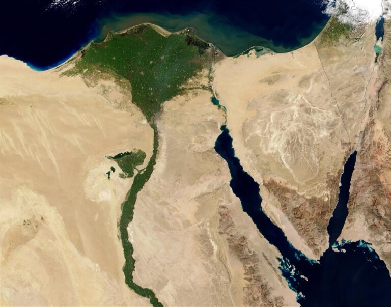
Commercial Satellite Imagery Providers
Private satellite companies offer cartographers access to imagery that surpasses government datasets in resolution, frequency, and specialized capabilities. These commercial providers deliver data streams that traditional sources simply can’t match for detailed mapping projects.
Beyond Traditional Government Sources
Commercial providers deliver imagery at resolutions exceeding government datasets by significant margins. Companies like Maxar Technologies and Planet Labs capture imagery at 30-50 centimeter resolution compared to Landsat’s 30-meter pixels. You’ll access near real-time acquisitions within hours of capture rather than waiting weeks for government processing cycles. Private providers offer flexible licensing agreements that accommodate specific project needs, unlike restrictive government terms that limit commercial applications.
High-Frequency Earth Observation Data
Daily revisit capabilities from commercial constellations transform temporal mapping approaches. Planet’s fleet of 200+ satellites captures every location on Earth daily, enabling you to track rapid changes in urban development, deforestation, or disaster response. High-frequency data streams support time-series analysis for monitoring seasonal vegetation patterns, construction progress, or environmental changes. You can detect and map changes within 24-48 hours rather than waiting for monthly or seasonal updates from traditional sources.
Specialized Imagery for Niche Applications
Commercial providers offer specialized sensors tailored for specific cartographic applications. Hyperspectral imagery from companies like Airbus enables detailed mineral mapping and vegetation analysis beyond standard RGB or multispectral capabilities. Synthetic Aperture Radar (SAR) data penetrates cloud cover and provides all-weather mapping capabilities essential for tropical or frequently clouded regions. You’ll access thermal infrared imagery for urban heat mapping, agricultural monitoring, and infrastructure assessment that government sources rarely provide at commercial resolutions.
Open Government Data Portals
Government agencies worldwide maintain extensive geographic databases that often surpass commercial alternatives in both detail and accuracy. These portals offer cartographers direct access to authoritative datasets ranging from administrative boundaries to infrastructure networks.
Municipal and Regional Data Repositories
City and county data portals provide street-level geographic information unavailable through federal sources. Major metropolitan areas like New York City, Chicago, and Los Angeles maintain comprehensive GIS databases containing building footprints, zoning boundaries, and land use classifications. You’ll find datasets covering property parcels, transportation networks, and demographic boundaries with quarterly updates reflecting local changes. Regional planning organizations supplement municipal data with watershed boundaries, transportation corridors, and environmental monitoring stations across multi-county areas.
Administrative Boundary Information
Government boundary datasets offer precision-verified geographic limits for all jurisdictional levels. The U.S. Census Bureau’s TIGER/Line files provide congressional districts, school districts, and municipal boundaries with annual updates reflecting redistricting changes. State geographic information offices maintain detailed county subdivisions, voting precincts, and special district boundaries often unavailable elsewhere. International boundary data through agencies like Natural Resources Canada and Ordnance Survey delivers similar precision for cross-border cartographic projects requiring jurisdictional accuracy.
Infrastructure and Planning Dataset Access
Planning departments release infrastructure datasets essential for transportation and utility mapping projects. State departments of transportation provide highway networks, bridge locations, and traffic monitoring stations with maintenance schedules and condition assessments. Utility commissions maintain electric transmission lines, natural gas pipelines, and telecommunications infrastructure through public safety mapping requirements. You’ll access zoning maps, future land use plans, and development project locations through local planning portals, enabling comprehensive infrastructure analysis for cartographic visualization.
Conclusion
These seven alternative data sources open new possibilities for your cartographic projects beyond traditional mapping resources. You’ll discover that combining multiple sources creates richer more accurate visualizations that tell compelling geographic stories.
The key to success lies in matching your data source to your project’s specific requirements. Whether you need real-time updates from IoT sensors or historical context from archived maps each source offers unique advantages for different mapping challenges.
Remember to consider data quality privacy requirements and integration complexity when selecting your sources. Start with one or two alternative datasets and gradually expand your toolkit as you gain experience with these innovative approaches to modern cartography.
Frequently Asked Questions
What are the main limitations of traditional cartographic datasets?
Traditional datasets like government databases and commercial mapping services often lack necessary detail and real-time updates. They may not capture current geographic changes or provide the granular information needed for specific mapping projects. This has led cartographers to seek alternative data sources for more accurate and timely visualizations.
How does OpenStreetMap compare to commercial mapping alternatives?
OpenStreetMap is the world’s largest collaborative mapping initiative that rivals commercial alternatives in detail and accuracy. It offers real-time updates through community-driven contributions, with volunteers adding millions of geographic features daily. The platform provides local knowledge and immediate updates, making it particularly valuable for emergency response and urban planning.
Can social media data be used effectively for cartographic projects?
Yes, social media platforms generate millions of geotagged posts daily, providing real-time geographic patterns that traditional sources miss. Cartographers can mine location data from platforms like Instagram and Twitter using APIs to extract coordinates and metadata for spatial analysis, helping identify activity hotspots and human movement patterns.
What privacy considerations apply when using social media data for mapping?
When using social media data, cartographers must anonymize user information, respect platform terms of service, and maintain transparency in data collection methods. It’s important to acknowledge representational bias in social media data and ensure ethical practices throughout the mapping process to protect user privacy.
How do IoT sensor networks enhance modern cartography?
IoT sensor networks provide continuous environmental and infrastructure data streams that transform static maps into dynamic visualizations. Environmental sensors capture air quality, temperature, and precipitation data, while urban infrastructure sensors monitor transportation networks and public facilities, enabling real-time mapping applications that reflect current conditions.
What advantages do drones offer for cartographic data collection?
Drones provide on-demand aerial perspectives with centimeter-level accuracy, surpassing traditional satellite imagery resolution. They enable cost-effective data collection through autonomous flight planning and are particularly valuable for emergency response teams and urban planners conducting rapid damage assessments and construction monitoring.
How can historical maps contribute to modern cartographic projects?
Historical archives and digitized maps provide centuries of geographic documentation, revealing temporal changes in landscapes and settlements. These maps serve as geographic baselines for change detection analysis and enable quantifiable comparisons between historical and modern features, helping cartographers understand long-term geographic evolution.
What benefits do commercial satellite imagery providers offer?
Commercial satellite providers like Maxar Technologies and Planet Labs offer high-resolution imagery with near real-time data acquisition capabilities. They provide high-frequency earth observation data for time-series analysis and specialized sensors like hyperspectral and SAR imagery, enabling rapid mapping updates and specialized applications.
How do Open Government Data Portals support cartographic work?
Open Government Data Portals provide access to extensive geographic databases maintained by government agencies, offering authoritative datasets including administrative boundaries and infrastructure networks. These portals often surpass commercial alternatives in detail and accuracy, providing essential data for comprehensive transportation and utility mapping projects.
What integration methods work best for incorporating diverse data sources?
Successful integration involves using GIS workflows and software applications that can handle multiple data formats and sources. Cartographers should focus on targeted data extraction methods, ensure data compatibility across platforms, and implement real-time streaming capabilities for dynamic visualizations that combine traditional and unconventional data sources effectively.