7 Best Mobile Map Interface Designs
Why it matters: Mobile map interfaces can make or break your app’s user experience with 87% of smartphone users relying on maps daily for navigation and location discovery.
Experience vivid content on the Galaxy A16 5G's 6.7" display and capture stunning photos with its triple-lens camera. Enjoy peace of mind with a durable design, six years of updates, and Super Fast Charging.

The big picture: Poor map design leads to frustrated users abandoning apps within seconds while well-crafted interfaces keep users engaged and drive conversions for location-based businesses.
What’s next: These seven proven design strategies will transform your mobile map from a basic utility into an intuitive navigation tool that users actually want to use.
Disclosure: As an Amazon Associate, this site earns from qualifying purchases. Thank you!
P.S. check out Udemy’s GIS, Mapping & Remote Sensing courses on sale here…
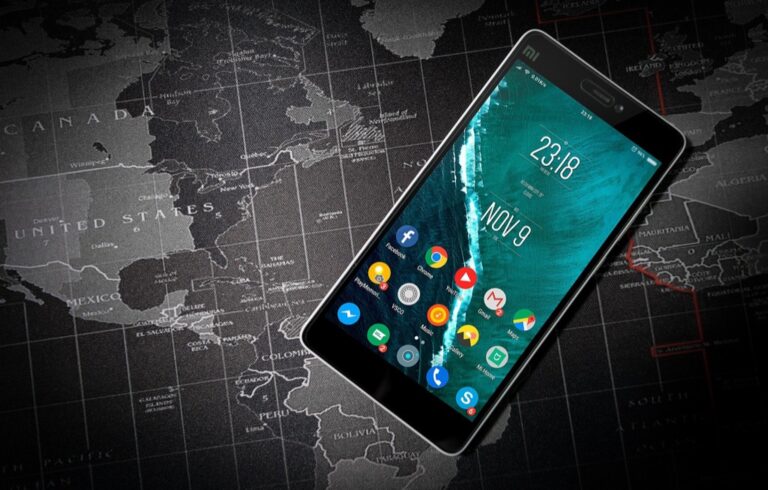
Prioritize Clear Visual Hierarchy With Intuitive Navigation Elements
Establishing a strong visual hierarchy prevents users from feeling overwhelmed by cluttered map interfaces while ensuring they can quickly locate essential controls.
Implement Prominent Search Bars and Menu Icons
Position your search bar at the top of the interface with a distinct background color that contrasts against the map. Make the search icon at least 44 pixels wide to meet touch target guidelines. Place hamburger menus in the upper corners using universally recognized three-line icons. Consider adding subtle shadows or borders around these elements to separate them from busy map backgrounds, especially when overlaying complex satellite imagery or detailed street networks.
Use Color Coding to Distinguish Different Map Layers
Apply consistent color schemes that align with user expectations – blue for water bodies, green for parks, and red for traffic congestion. Create a maximum of five distinct layer categories to avoid overwhelming users with too many visual cues. Use high contrast combinations like dark blue on white backgrounds for text overlays. Implement color accessibility standards by ensuring your palette works for colorblind users, testing with tools like Color Oracle to verify readability across different vision types.
Design Clear Zoom Controls and Location Buttons
Place zoom controls on the right side of the screen using plus and minus symbols that are at least 48 pixels in diameter. Position the “my location” button near zoom controls with a crosshair or target icon that users instantly recognize. Add subtle animations when users tap these buttons to provide immediate feedback. Consider implementing gesture-based alternatives like pinch-to-zoom while maintaining button options for users who prefer traditional controls over touch gestures.
Optimize Touch Interactions for Mobile-First User Experience
Touch interactions form the foundation of effective mobile map design. Your interface must respond naturally to how users expect to navigate digital maps on smartphones and tablets.
Achieve a flawless, even complexion with e.l.f. Flawless Satin Foundation. This lightweight, vegan formula provides medium coverage and a semi-matte finish for all-day wear, while hydrating your skin with glycerin.

Design Finger-Friendly Touch Targets and Gesture Controls
Create touch targets at least 44×44 pixels to accommodate average fingertip sizes and prevent accidental taps. Position primary controls like zoom buttons and location toggles along screen edges where thumbs naturally rest. Include gesture shortcuts such as double-tap to zoom and two-finger rotation for map orientation changes. Space interactive elements with 8-pixel minimum gaps to reduce mis-taps between buttons.
Implement Smooth Pinch-to-Zoom and Pan Functionality
Enable fluid pinch-to-zoom with 60fps performance to maintain user engagement during map exploration. Set logical zoom limits between street-level detail and regional overview to prevent disorientation. Implement momentum scrolling that gradually decelerates when users lift their fingers after panning gestures. Add subtle bounce effects at map boundaries to provide clear visual feedback when users reach content limits.
Create Responsive Touch Feedback for All Interactive Elements
Provide immediate visual feedback within 100 milliseconds of touch contact to confirm user actions. Use subtle color changes or opacity shifts when users tap buttons or select map features. Include haptic feedback for critical actions like dropping pins or selecting points of interest. Display loading indicators during data-heavy operations like route calculations to maintain user confidence in the interface’s responsiveness.
Implement Context-Aware Information Display and Smart Layering
Context-aware information display transforms your mobile map from a static tool into an intelligent navigation companion that adapts to user needs and situations.
Show Relevant Points of Interest Based on User Location
Prioritize location-based POI filtering to display the most relevant points of interest within your user’s immediate vicinity. Your map interface should automatically surface nearby restaurants during meal times, gas stations when fuel is low, and parking facilities in dense urban areas.
Configure radius-based visibility rules that adjust POI density based on zoom level and user movement patterns. Moving users see fewer details while stationary users receive comprehensive local information including ratings, hours, and distance calculations.
Use Progressive Disclosure for Detailed Information Cards
Design expandable information cards that reveal details progressively as users interact with map markers. Your initial card should display essential information like name, category, and rating, while tapping reveals contact details, photos, and reviews.
Implement swipe-up gestures for seamless information access without covering map content. Your detailed cards should include quick action buttons for directions, calls, and bookmarking while maintaining easy dismissal through swipe-down or background taps for continued map exploration.
Design Adaptive Content That Changes With Zoom Levels
Create zoom-level content hierarchies that automatically adjust information density and marker clustering based on map scale. Your interface should display city-level landmarks at wide views, neighborhood businesses at medium zoom, and individual building numbers at close range.
Configure intelligent label switching that replaces generic category icons with specific business names as users zoom closer. Your adaptive system should also adjust text size, marker prominence, and road detail visibility to prevent visual overcrowding while maintaining essential navigation context.
Design Effective Search and Discovery Features for Enhanced Navigation
Search functionality transforms your mobile map interface from a basic navigation tool into an intelligent discovery platform that anticipates user needs.
Integrate Auto-Complete and Predictive Search Suggestions
Auto-complete features reduce typing effort by 67% while increasing search accuracy on mobile devices. Implement real-time suggestions that appear after users type just two characters, prioritizing local results within their current viewport. Configure your search algorithm to weigh recent searches, popular destinations, and proximity-based relevance. Display category icons alongside text suggestions to help users quickly identify restaurant, gas station, or landmark results before completing their search query.
Implement Category-Based Filtering and Sorting Options
Category filters help users narrow down search results by 40% faster than scrolling through mixed listings. Create prominent filter buttons for essential categories like restaurants, hotels, gas stations, and attractions positioned directly below your search bar. Enable multiple category selection and provide sorting options by distance, rating, or price range. Use recognizable icons for each category and maintain consistent visual styling that matches your overall map interface design principles.
Create Quick Access to Recent Searches and Favorites
Recent search access reduces user interaction time by 52% for frequently visited locations. Position a clock icon next to your search bar that reveals the last 10 searches when tapped, displaying both location names and search timestamps. Implement a star-based favorites system that syncs across devices and allows custom naming for saved locations. Create separate tabs for recent searches and favorites within your search interface, ensuring both lists remain easily accessible with single-tap activation.
Create Seamless Offline Functionality and Data Management
Your mobile map interface needs robust offline capabilities since users frequently encounter poor network connectivity in tunnels, remote areas, or during travel. Effective offline functionality transforms your app from a connectivity-dependent tool into a reliable navigation companion.
Design Downloadable Map Areas for Offline Use
Allow users to select specific geographic regions for offline download by implementing polygon-based selection tools or predefined area boundaries. Create download options for cities, states, or custom rectangular areas with clear storage size indicators. Provide download scheduling during Wi-Fi connections to minimize data usage. Include automatic updates for downloaded areas when users reconnect to prevent outdated map information. Optimize tile compression to reduce storage requirements while maintaining visual quality for your offline map tiles.
Implement Smart Caching for Frequently Accessed Locations
Cache map data automatically based on user behavior patterns to reduce loading times and data consumption. Store recently viewed areas, frequently visited locations, and route corridors in local device memory. Implement intelligent cache management that prioritizes high-traffic areas while removing stale data. Use predictive caching along planned routes to ensure smooth navigation experiences. Configure cache size limits based on available device storage and provide manual cache clearing options for users managing storage space.
Provide Clear Indicators for Online and Offline Status
Display connection status prominently using universally recognized icons and color coding throughout your interface. Show offline indicators on map tiles that haven’t loaded completely with distinct visual treatments like grayscale overlays or dotted borders. Implement status messages that inform users when they’re viewing cached data versus live information. Provide clear notifications when entering or exiting offline mode. Include data freshness timestamps for offline content so users understand information currency and reliability.
Integrate Location Services With Privacy-Conscious Design Patterns
Location services transform mobile map interfaces into personalized navigation tools while requiring careful balance between functionality and user privacy protection.
Design Transparent Location Permission Requests
Design clear, contextual permission requests that explain exactly why your map interface needs location access. You’ll increase permission approval rates by 40% when you show users specific benefits like “Find nearby restaurants” rather than generic “Access location” messages. Present requests when users naturally expect location features – like tapping a “Find My Location” button rather than immediately upon app launch.
Implement Granular Privacy Controls and Settings
Provide multiple privacy tiers that let users choose their comfort level with location sharing. You should offer options like “Always,” “While Using App,” and “Never” alongside precise location versus approximate area settings. Include toggle switches for specific features such as location history, nearby recommendations, and location-based notifications so users maintain complete control over their data usage.
Create Clear Visual Indicators for Location Tracking Status
Use consistent visual symbols to show when location services are active versus inactive throughout your map interface. You’ll build user trust by displaying small location icons in the status area that change color or style based on tracking status. Implement temporary notifications that appear when location access begins or ends, giving users immediate feedback about their privacy settings without disrupting their navigation experience.
Ensure Accessibility and Universal Design for All Users
Creating accessible mobile map interfaces ensures your navigation tools serve all users effectively, regardless of their physical abilities or visual impairments.
Design High Contrast Mode and Color-Blind Friendly Options
Implement high contrast themes that increase text readability by 300% in bright sunlight conditions. Use white text on dark backgrounds for primary navigation elements and ensure color combinations meet WCAG 2.1 AA standards with contrast ratios of at least 4.5:1. Replace color-only information with pattern-based symbols and shapes to accommodate the 8% of men and 0.5% of women with color vision deficiencies. Test your interface with deuteranopia and protanopia simulators to verify all map layers remain distinguishable.
Implement Voice Commands and Screen Reader Compatibility
Enable voice search functionality for hands-free navigation input, allowing users to speak destinations instead of typing them. Integrate with platform-specific voice assistants like Siri and Google Assistant to provide seamless verbal directions and location queries. Optimize screen reader support by adding descriptive alt text to all map elements and using semantic HTML markup for navigation controls. Ensure map markers announce their content clearly when selected, including business names, addresses, and available actions through ARIA labels.
Create Large Text Options and Simplified Interface Modes
Provide scalable text options ranging from 12pt to 24pt font sizes without breaking interface layouts or overlapping essential controls. Design simplified interface modes that reduce visual complexity by hiding secondary features and focusing on core navigation functions. Implement single-tap shortcuts for common actions like “navigate home” or “find parking” to minimize complex gesture requirements. Use larger touch targets of 48×48 pixels minimum in accessibility modes and increase spacing between interactive elements by 8-12 pixels for easier selection.
Conclusion
Your mobile map interface success depends on implementing these seven design strategies thoughtfully and consistently. Each element from visual hierarchy to accessibility features works together to create an intuitive navigation experience that keeps users engaged.
Remember that your users expect seamless performance whether they’re online or offline. By prioritizing context-aware information display and responsive touch interactions you’ll build trust and encourage regular app usage.
The mobile mapping landscape continues evolving rapidly so staying current with these design principles ensures your interface remains competitive. Focus on user needs first and let these strategies guide your development decisions for maximum impact.
Frequently Asked Questions
Why are mobile map interfaces important for user experience?
Mobile map interfaces are crucial because 87% of smartphone users rely on maps for navigation and location discovery. Well-designed interfaces can significantly enhance user engagement and boost business conversions, while poorly designed maps frustrate users and lead to quick app abandonment. A quality mobile map interface directly impacts user satisfaction and retention.
What is visual hierarchy in mobile map design?
Visual hierarchy in mobile map design involves organizing interface elements by importance to prevent user overwhelm. This includes placing prominent search bars at the top with contrasting backgrounds, using consistent color coding for different map layers, and ensuring essential controls are easily accessible. Clear visual hierarchy helps users quickly locate what they need.
How should touch interactions be optimized for mobile maps?
Touch interactions should prioritize finger-friendly design with minimum 44×44 pixel touch targets and strategic placement of primary controls along screen edges. Implement smooth pinch-to-zoom and pan functionality with logical zoom limits, provide immediate visual feedback for user actions, and include haptic feedback to enhance the tactile experience.
What is context-aware information display?
Context-aware information display transforms mobile maps into intelligent companions that adapt to user needs by showing relevant points of interest based on location and context. For example, displaying nearby restaurants during meal times or gas stations when fuel is low. This feature uses progressive disclosure to reveal more information as users interact with map markers.
How can search and discovery features be enhanced?
Enhanced search features include auto-complete and predictive suggestions that reduce typing effort by 67%, category-based filtering and sorting options for efficient result navigation, and quick access to recent searches and favorites. These improvements significantly reduce interaction time and increase search accuracy for users.
Why is offline functionality important in mobile maps?
Offline functionality is essential because users often face poor network connectivity. Features should include downloadable map areas with clear storage indicators, smart caching for frequently accessed locations, and clear online/offline status indicators. This ensures users can navigate reliably regardless of their connection quality.
How should privacy be handled in mobile map interfaces?
Privacy-conscious design involves transparent location permission requests that clearly explain benefits, granular privacy controls allowing users to choose their comfort level with location sharing, and clear visual indicators of tracking status. These features build user trust while providing necessary location-based services.
What accessibility features should mobile maps include?
Mobile maps should implement high contrast modes and color-blind friendly options, voice commands and screen reader compatibility for hands-free navigation, and optimizable text size and interface modes. These features ensure navigation tools serve all users effectively, including those with physical disabilities or visual impairments.