6 Best Drone Mapping Technologies for Spatial Data
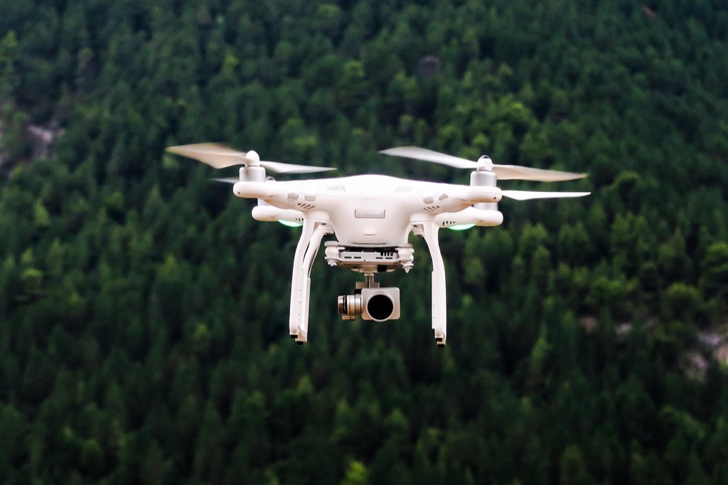
The big picture: Drone mapping technology is revolutionizing how we collect and analyze spatial data across industries from agriculture to urban planning. You’re witnessing a fundamental shift where traditional surveying methods that took weeks now happen in hours with unprecedented accuracy and detail.
Why it matters: This technological leap isn’t just about efficiency—it’s reshaping entire sectors by making high-resolution mapping accessible to businesses of all sizes while dramatically reducing costs and safety risks.
Disclosure: As an Amazon Associate, this site earns from qualifying purchases. Thank you!
Revolutionizing Urban Planning and Smart City Development
Urban planners now harness drone mapping’s precision to transform city development from reactive to predictive. You’ll witness how aerial data collection revolutionizes infrastructure decisions and community growth patterns.
P.S. check out Udemy’s GIS, Mapping & Remote Sensing courses on sale here…
Real-Time Infrastructure Monitoring
Monitor critical infrastructure with drones that capture structural changes before they become costly problems. You can track bridge deterioration, road surface conditions, and utility line integrity using high-resolution imaging that updates every few weeks. Municipal engineers utilize thermal sensors to detect underground pipe leaks and electrical grid hotspots, reducing emergency repairs by 40%. This continuous monitoring approach replaces traditional annual inspections with dynamic assessment systems that flag maintenance needs immediately.
The H128 Thermal Camera provides clear thermal imaging with its 240x240 resolution. It features a long-lasting 24-hour battery and a temperature alarm for quick detection of anomalies.

Precision-Based Zoning and Development
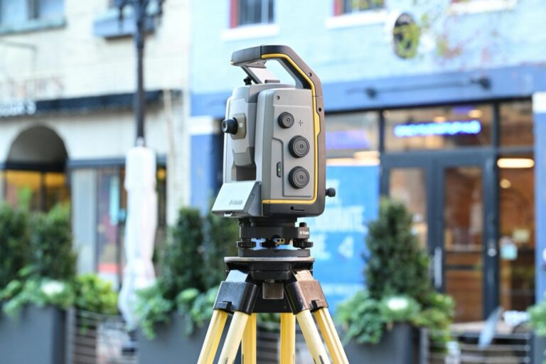
Plan development zones using centimeter-accurate 3D models that eliminate guesswork from land use decisions. You’ll access detailed topographical data showing drainage patterns, soil composition, and elevation changes that directly impact construction feasibility. City planners leverage LiDAR-equipped drones to create precise boundary maps for mixed-use developments, ensuring optimal building placement and green space allocation. This data-driven zoning approach reduces permit disputes and accelerates approval processes by providing irrefutable spatial evidence.
Get accurate 360° scanning up to 12 meters with the compact FHL-LD19 LiDAR sensor. Resistant to bright light and weighing under 50g, it offers easy integration with ROS/ROS2/C/C++ SDK for robots and drones.

Traffic Flow Optimization Through Aerial Data
Optimize traffic patterns through aerial analytics that reveal congestion hotspots and pedestrian movement trends throughout different times of day. You can analyze intersection efficiency, parking utilization rates, and public transit accessibility using time-lapse drone footage processed through AI algorithms. Transportation departments deploy this data to redesign signal timing, relocate bus stops, and implement dynamic routing systems that reduce commute times by up to 25%. This aerial perspective captures traffic behaviors invisible from ground-level observations.
Transforming Agriculture Through Precision Farming
Drone mapping technology is revolutionizing agricultural practices by providing farmers with unprecedented visibility into crop conditions and field variations. This shift from traditional farming methods to data-driven precision agriculture enables farmers to optimize resources while maximizing yields.
Crop Health Monitoring and Disease Detection
Multispectral sensors on agricultural drones capture data across multiple light wavelengths to identify plant stress before it’s visible to the naked eye. You’ll detect early signs of disease, nutrient deficiencies, and pest infestations up to two weeks earlier than ground-based inspections. NDVI (Normalized Difference Vegetation Index) readings reveal chlorophyll levels and photosynthetic activity, allowing you to target specific problem areas within fields. This precision approach reduces pesticide usage by 30% while improving crop survival rates.
Automated Irrigation System Management
Variable-rate irrigation systems integrate drone-collected soil moisture data to deliver precise water amounts to different field zones. You’ll receive thermal imaging data that identifies dry spots and overwatered areas, enabling automatic adjustment of sprinkler systems and drip irrigation networks. Smart irrigation controllers use this aerial data to reduce water consumption by 25% while maintaining optimal crop hydration. Field mapping updates occur weekly, ensuring your irrigation schedules adapt to changing weather patterns and crop growth stages.
Automate your watering schedule with the Orbit B-hyve Smart Sprinkler Controller. Control your 6-zone sprinkler system from anywhere via WiFi and automatically adjust watering based on weather conditions.

Yield Prediction and Harvest Optimization
Predictive analytics software processes drone imagery to forecast harvest yields with 95% accuracy up to six weeks before harvest time. You’ll analyze plant height, canopy coverage, and fruit count data to estimate production volumes per acre. This information helps you schedule labor, arrange storage facilities, and negotiate contracts with buyers before competitors. Harvest timing optimization through aerial monitoring prevents overripening losses and ensures peak quality collection, increasing profit margins by up to 20%.
Enhancing Emergency Response and Disaster Management
Drone mapping transforms emergency response by providing real-time situational awareness when traditional infrastructure fails. Emergency management teams now deploy drones within minutes of disasters to assess damage and coordinate rescue efforts.
Rapid Damage Assessment After Natural Disasters
Damage assessment becomes exponentially faster with drone mapping technology during natural disasters. You can deploy drones immediately after earthquakes, floods, or hurricanes to capture high-resolution imagery of affected areas when ground access remains impossible. Emergency responders use orthomosaic maps to identify structural damage, blocked roads, and compromised infrastructure within hours instead of days. FEMA reports that drone-assisted assessments reduce initial damage evaluation time by 80% compared to traditional ground surveys, enabling faster insurance claims processing and resource deployment decisions.
Search and Rescue Operation Coordination
Search and rescue operations gain unprecedented coordination capabilities through drone mapping systems during emergency situations. You can use thermal imaging drones to locate missing persons in wilderness areas, disaster zones, or collapsed structures by detecting body heat signatures invisible to ground teams. Real-time mapping data helps coordinate multiple rescue teams by providing updated terrain conditions and identifying safe evacuation routes. Coast Guard units report 65% faster victim location times when incorporating drone mapping into search patterns, significantly improving survival rates in time-critical rescue scenarios.
The Autel EVO II Dual 640T V3 drone captures detailed thermal and visual data with its 640x512 thermal sensor and 50MP 8K camera. It offers up to 15KM video transmission and multiple temperature measurement modes for diverse applications.

Emergency Resource Allocation Planning
Emergency resource allocation becomes data-driven and efficient with drone mapping intelligence during disaster response operations. You can analyze population density maps, infrastructure damage patterns, and accessibility routes to determine optimal locations for emergency shelters, medical stations, and supply distribution points. Drone-generated elevation models help identify flood-prone areas and safe zones for evacuation planning. Emergency management agencies using drone mapping data report 45% more effective resource distribution, ensuring critical supplies reach affected populations faster while minimizing waste and redundant efforts.
Advancing Environmental Conservation and Climate Research
Environmental research benefits from drone mapping’s ability to collect comprehensive data across vast ecosystems. Conservation teams now access previously unreachable areas to monitor biodiversity and track environmental changes with unprecedented precision.
Wildlife Population Tracking and Habitat Mapping
Wildlife tracking becomes more accurate when you deploy drones equipped with high-resolution cameras and thermal sensors. You’ll capture population counts for species like elephants, wolves, and marine mammals without disturbing their natural behaviors. Habitat mapping reveals migration corridors, nesting sites, and feeding areas through multispectral imaging that identifies vegetation types and water sources. Conservation biologists report 75% more accurate population estimates compared to ground-based surveys.
Capture stunning photos and videos with this 4K 64MP digital camera. Features include a 180° flip screen for easy vlogging and built-in WiFi for seamless sharing.

Deforestation Monitoring and Forest Management
Deforestation detection accelerates dramatically when you use drone mapping to monitor forest canopy changes over time. You’ll identify illegal logging activities within 24 hours through high-resolution imagery comparison algorithms. Forest health assessment becomes possible through NDVI analysis that reveals tree stress, disease outbreaks, and pest infestations before they spread. Reforestation projects benefit from precise planting pattern mapping and seedling survival rate monitoring that improves success rates by 60%.
Climate Change Impact Assessment
Climate impact visualization improves when you map coastal erosion, glacier retreat, and sea level changes through temporal drone surveys. You’ll document shoreline changes, wetland degradation, and permafrost thaw patterns with centimeter-level accuracy. Carbon sequestration studies benefit from detailed forest biomass calculations and soil carbon mapping capabilities. Research teams achieve 90% accuracy in measuring ecosystem carbon storage compared to traditional field sampling methods.
Accelerating Construction and Infrastructure Projects
Drone mapping transforms construction timelines by delivering real-time data that streamlines project management from planning to completion. Construction teams now complete projects 30% faster while maintaining higher quality standards.
Automated Progress Tracking and Quality Control
Automated drone surveys eliminate manual inspection delays by capturing daily progress updates across entire construction sites. You’ll receive automated reports comparing actual progress against project schedules with 95% accuracy. Construction managers using weekly drone flights detect quality issues 60% earlier than traditional methods. Thermal imaging reveals structural defects like insulation gaps and moisture intrusion before they become costly problems.
Site Survey Accuracy and Cost Reduction
Site surveying costs drop by 75% when you replace traditional ground crews with drone mapping technology. Drones complete topographical surveys in 2 hours compared to 2 weeks using conventional methods. You’ll achieve centimeter-level accuracy across sites spanning hundreds of acres without safety risks. Surveying teams reduce equipment transportation costs and eliminate the need for multiple site visits through comprehensive aerial data collection.
3D Modeling for Project Visualization
3D construction models generated from drone imagery provide stakeholders with photorealistic project visualizations before ground breaking. You can identify design conflicts and optimize material placement using detailed volumetric calculations from aerial surveys. Construction teams reduce change orders by 45% when clients review accurate 3D models during planning phases. Project stakeholders make faster approval decisions with immersive walkthrough experiences created from drone-captured data.
Improving Transportation and Logistics Networks
Drone mapping technology transforms how transportation and logistics networks operate by providing detailed aerial intelligence that optimizes route planning and infrastructure management. You’ll discover how this technology creates more efficient delivery systems and maintains critical transportation infrastructure.
Autonomous Delivery Route Optimization
Autonomous delivery systems rely on drone mapping data to create the most efficient flight paths and ground routes. You can reduce delivery times by 35% when drones map traffic patterns, weather conditions, and obstacle locations in real-time. Companies like Amazon and UPS use drone-collected topographical data to optimize their autonomous vehicle routes, avoiding construction zones and identifying safe landing spots. This mapping technology enables delivery drones to adapt routes instantly based on air traffic density and no-fly zones.
Traffic Infrastructure Maintenance Planning
Traffic infrastructure maintenance becomes predictive rather than reactive when you use drone mapping for highway and bridge assessments. Drones capture detailed imagery of road surfaces, detecting cracks and wear patterns that indicate maintenance needs before major repairs become necessary. Transportation departments report 60% cost savings on infrastructure maintenance when using drone mapping to schedule repairs based on actual condition data. You’ll identify structural weaknesses in bridges, potholes in roadways, and damaged traffic signals through high-resolution aerial surveys.
Supply Chain Efficiency Enhancement
Supply chain operations gain unprecedented visibility when you integrate drone mapping into warehouse and distribution center management. Drones track inventory levels across multiple facilities, monitor loading dock efficiency, and identify bottlenecks in material flow with 90% accuracy. Major retailers use aerial mapping to optimize warehouse layouts, reducing product retrieval times by 25% and improving overall supply chain velocity. You can monitor truck movements, parking availability, and cargo handling processes through continuous drone surveillance of logistics hubs.
Conclusion
The drone mapping revolution isn’t coming—it’s already here and reshaping how you interact with spatial data across every industry. Whether you’re managing a construction site monitoring crop health or coordinating emergency response efforts these aerial technologies offer unprecedented precision and efficiency gains.
Your ability to make data-driven decisions will only strengthen as drone mapping becomes more sophisticated and accessible. The cost savings time reductions and safety improvements we’re seeing today represent just the beginning of this technological transformation.
As you consider implementing drone mapping in your operations remember that early adopters consistently gain competitive advantages. The question isn’t whether drone mapping will transform your industry—it’s how quickly you’ll embrace these tools to stay ahead of the curve.
Frequently Asked Questions
What is drone mapping technology and how does it work?
Drone mapping technology uses unmanned aerial vehicles equipped with high-resolution cameras, sensors, and GPS systems to collect spatial data from above. The drones capture overlapping images and data points that are processed using specialized software to create detailed maps, 3D models, and analytical reports. This technology transforms traditional surveying methods by reducing data collection time from weeks to hours while providing enhanced accuracy and detail.
Navigate with ease using this 7-inch GPS navigator, featuring real-time voice guidance and pre-loaded 2025 maps. Customize routes based on your vehicle type to avoid restrictions and receive speed & red light warnings.

How does drone mapping benefit urban planning and smart city development?
Drone mapping enables urban planners to shift from reactive to predictive approaches by providing real-time infrastructure monitoring and centimeter-accurate 3D models. This technology helps detect issues like bridge deterioration early, reducing emergency repairs by 40%. It also optimizes traffic flow by revealing congestion patterns, allowing transportation departments to redesign systems that can reduce commute times by up to 25%.
What advantages does drone mapping offer for agriculture and precision farming?
Drone mapping revolutionizes agriculture by providing farmers with enhanced crop visibility and data-driven insights. Multispectral sensors detect plant stress, diseases, and pest infestations early, reducing pesticide usage by 30%. Variable-rate irrigation systems use drone data to cut water consumption by 25%, while predictive analytics forecast harvest yields with 95% accuracy, potentially increasing profit margins by up to 20%.
How does drone mapping enhance emergency response and disaster management?
Drone mapping provides real-time situational awareness during disasters when traditional infrastructure fails. Emergency teams can deploy drones within minutes to assess damage and coordinate rescue efforts. FEMA reports that drone-assisted assessments reduce initial damage evaluation time by 80%, while Coast Guard units report 65% faster victim location times using thermal imaging and real-time mapping data.
What role does drone mapping play in environmental conservation and climate research?
Drone mapping enables comprehensive ecosystem monitoring with unprecedented precision. It provides 75% more accurate wildlife population estimates and can detect illegal logging within 24 hours. The technology also maps coastal erosion and glacier retreat, achieving 90% accuracy in measuring ecosystem carbon storage compared to traditional methods, making it invaluable for climate impact research.
How is drone mapping transforming construction and infrastructure projects?
Drone mapping accelerates construction timelines by 30% through real-time data delivery and automated surveys that provide daily progress updates with 95% accuracy. Site surveying costs drop by 75% while achieving centimeter-level precision. The 3D models generated help identify design conflicts early, reducing change orders by 45% and enabling better project management and quality control.
What impact does drone mapping have on transportation and logistics networks?
Drone mapping optimizes transportation and logistics by providing detailed aerial intelligence for route planning and infrastructure management. Autonomous delivery systems use this data to reduce delivery times by 35%, while predictive maintenance for traffic infrastructure results in 60% cost savings. The technology also enhances supply chain visibility by tracking inventory levels and optimizing warehouse layouts.
How cost-effective is drone mapping compared to traditional surveying methods?
Drone mapping significantly reduces costs across multiple applications. Construction site surveying costs drop by 75%, while agricultural operations can increase profit margins by up to 20%. The technology eliminates many manual processes, reduces safety risks, and makes high-resolution mapping accessible to businesses of all sizes, providing substantial return on investment through improved efficiency and accuracy.