7 Effective Ways to Update Geographic Data That Transform Digital Maps
Why it matters: Your business decisions depend on accurate geographic data — but outdated information can cost you customers and revenue.
The big picture: From mapping software to delivery routes geographic data powers everything from urban planning to e-commerce logistics. When this information becomes stale your operations suffer and your competitive edge dulls.
What’s next: We’ll walk you through seven proven methods to keep your geographic datasets current and reliable so you can make smarter location-based decisions.
Disclosure: As an Amazon Associate, this site earns from qualifying purchases. Thank you!
P.S. check out Udemy’s GIS, Mapping & Remote Sensing courses on sale here…
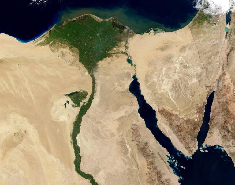
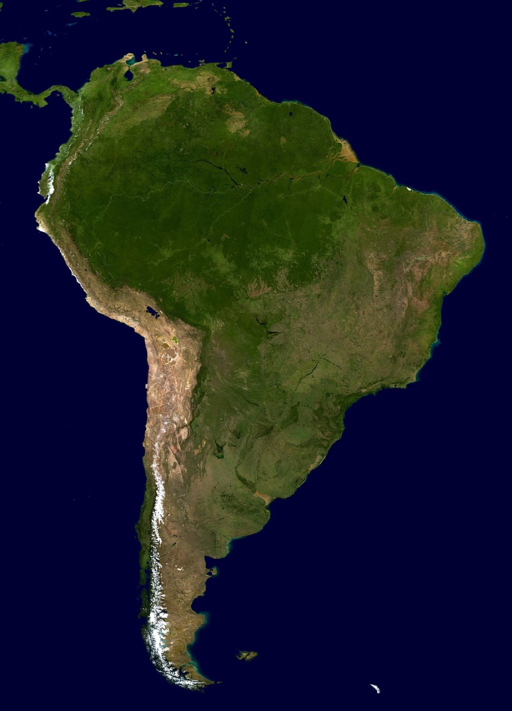
Automated Data Collection Through Satellite Imagery and Remote Sensing
Satellite-based data collection transforms geographic information management by providing continuous, comprehensive coverage of Earth’s surface changes. This approach eliminates manual field surveys while delivering consistent data quality across vast territories.
Real-Time Satellite Data Updates
Modern satellite constellations deliver geographic updates within hours of capture, enabling you to track infrastructure changes, natural disasters, and urban development as they occur. Commercial providers like Planet Labs and Maxar offer daily imagery with resolution down to 30 centimeters, while government satellites like Landsat provide free data every 16 days. You’ll receive automated alerts when significant changes appear in your areas of interest, streamlining your data maintenance workflow.
Integration With GIS Software Systems
Leading GIS platforms now feature direct satellite data feeds that automatically update your geographic layers without manual intervention. ArcGIS Online connects seamlessly with Esri’s Living Atlas, while QGIS integrates with multiple satellite providers through standardized web services. You can configure automated workflows that download, process, and incorporate new imagery into your existing datasets, maintaining data currency while reducing processing time from days to minutes.
Cost-Effective Large-Scale Monitoring
Satellite monitoring costs significantly less than traditional ground surveys when covering large areas, with pricing as low as $2 per square kilometer for medium-resolution imagery. You’ll achieve better cost efficiency by subscribing to area-based monitoring services rather than purchasing individual images, especially for regions exceeding 1,000 square kilometers. Open-source satellite data from Sentinel-2 and Landsat eliminates licensing costs entirely, making continuous monitoring accessible for budget-conscious projects while maintaining professional-grade accuracy standards.
Crowdsourcing Geographic Information From Local Communities
Local communities provide invaluable geographic data through their firsthand knowledge of neighborhood changes and emerging patterns. You’ll discover that residents often spot new developments, road closures, and infrastructure updates weeks before official databases reflect these changes.
Leveraging Mobile Apps for Citizen Reporting
Deploy location-based mobile applications like Waze, iNaturalist, or custom-built platforms to collect real-time geographic updates from community members. Configure push notifications to encourage users to report new businesses, construction projects, and accessibility changes in their immediate vicinity. Implement GPS-enabled photo submission features that automatically geotag images with precise coordinates, creating a comprehensive database of ground-truth observations that complement your existing datasets.
Implementing Quality Control Measures
Establish verification protocols that cross-reference citizen submissions with authoritative data sources before incorporating them into your geographic database. Set up automated flagging systems that identify suspicious reports based on location accuracy, submission frequency, and user credibility scores. Require multiple confirmations for significant changes like road closures or new landmarks, and implement review cycles where experienced volunteers validate submissions from newer contributors through field verification or satellite imagery comparison.
Building Community Engagement Programs
Create structured volunteer programs that train local residents in basic geographic data collection techniques and GPS usage protocols. Organize neighborhood mapping events where participants use standardized forms to document local changes, business openings, and infrastructure improvements. Develop recognition systems that reward consistent contributors with badges or certificates, while establishing clear communication channels through community forums where volunteers can discuss mapping challenges and share location-specific insights.
Utilizing Government and Municipal Data Sources
Government agencies maintain the most authoritative geographic datasets available, making them essential sources for your data update strategies. These official repositories provide legally verified boundaries, infrastructure records, and demographic information that forms the foundation of accurate mapping projects.
Achieve a flawless, even complexion with e.l.f. Flawless Satin Foundation. This lightweight, vegan formula provides medium coverage and a semi-matte finish for all-day wear, while hydrating your skin with glycerin.

Accessing Open Data Portals
Navigate federal portals like Data.gov and state-specific platforms to access comprehensive geographic datasets. These portals offer standardized formats including shapefiles, GeoJSON, and KML files that integrate seamlessly with your existing GIS workflows.
Download census boundaries, transportation networks, and land use classifications directly from TIGER/Line databases maintained by the U.S. Census Bureau. Most portals provide API access for automated downloads, enabling you to schedule regular data refreshes without manual intervention.
Verify update frequencies before incorporating portal data into your projects, as some datasets refresh monthly while others update annually.
Establishing Partnerships With Local Agencies
Contact planning departments, public works offices, and GIS coordinators to establish formal data-sharing agreements. Local agencies often maintain more current information than federal sources, particularly for infrastructure projects and zoning changes.
Negotiate reciprocal arrangements where you provide specialized mapping services in exchange for early access to updated datasets. Many municipalities welcome partnerships that enhance their own mapping capabilities while providing you with timely data updates.
Attend local GIS user group meetings to build relationships with agency staff and learn about upcoming data releases or format changes.
Regular Data Synchronization Protocols
Implement automated ETL processes using tools like FME or custom Python scripts to synchronize government datasets with your local databases. Schedule these updates during off-peak hours to minimize system impact.
Create change detection workflows that compare new government releases against your existing data, flagging discrepancies for manual review. This approach prevents wholesale data replacement while ensuring accuracy.
Establish version control systems that track data lineage and enable rollback capabilities when government updates contain errors or formatting issues.
Implementing GPS Technology and Field Surveys
GPS technology and field surveys provide the most accurate method for capturing real-time geographic data changes. This approach combines precision equipment with on-site verification to ensure your geographic datasets maintain survey-grade accuracy.
Professional Survey Equipment Integration
Professional GPS receivers offer centimeter-level accuracy through Real-Time Kinematic (RTK) positioning systems. You’ll achieve precise coordinates by connecting handheld units like Trimble GeoExplorer or Leica Zeno series to base stations that broadcast correction signals. These systems integrate seamlessly with GIS software through standardized data formats, allowing immediate upload of field measurements to your geographic databases. Survey-grade equipment also supports multiple coordinate systems and datum transformations, ensuring compatibility with existing datasets while maintaining spatial accuracy throughout your data collection workflow.
Get fast, accurate GPS positioning for your laptop, PC, car, or boat with this USB receiver. It features a high-performance chip for multi-GNSS support and a magnetic base for easy installation.

Mobile GPS Data Collection Tools
Mobile applications transform smartphones into powerful geographic data collection devices for updating location information. Apps like Collector for ArcGIS and QField enable field teams to capture attributes, photos, and GPS coordinates simultaneously using built-in receivers. You can design custom forms that standardize data entry while reducing errors through dropdown menus and validation rules. These tools work offline in remote areas, synchronizing updates when cellular coverage returns. Cloud-based platforms automatically distribute collected data to team members, creating real-time updates that keep your geographic databases current without manual processing delays.
Experience vivid content on the Galaxy A16 5G's 6.7" display and capture stunning photos with its triple-lens camera. Enjoy peace of mind with a durable design, six years of updates, and Super Fast Charging.

Accuracy Verification Techniques
Accuracy verification ensures your GPS-collected data meets project specifications through systematic quality control procedures. You’ll establish ground control points using known coordinates from survey benchmarks or previously verified locations to test equipment calibration. Cross-referencing GPS measurements with aerial imagery or existing maps reveals discrepancies that require investigation before database integration. Post-processing techniques like differential correction improve accuracy by comparing field measurements to reference station data. Document precision levels for each data collection session, creating metadata that informs future users about spatial reliability and appropriate applications for your updated geographic information.
Improve drone mapping accuracy with this 10-pack of numbered (0-9) 24"x24" GCP targets. Durable, waterproof Oxford cloth with high-contrast black and white design ensures clear visibility and reliable performance in various conditions.

Leveraging Internet of Things (IoT) Sensors for Real-Time Updates
IoT sensors revolutionize geographic data collection by providing continuous monitoring capabilities that capture changes as they occur. You’ll discover how sensor networks transform traditional surveying into dynamic real-time systems.
Environmental Monitoring Sensors
Environmental sensors automatically track weather patterns, air quality levels, and natural resource changes across your study areas. You can deploy temperature sensors that measure microclimates in urban heat islands, humidity monitors that track moisture levels in wetlands, and water quality sensors that detect chemical changes in rivers. These devices typically transmit data every 15-30 minutes, enabling you to identify environmental trends and sudden changes like pollution spikes or drought conditions. Modern environmental sensor networks integrate seamlessly with GIS platforms through APIs and cloud-based data feeds.
Measure temperature, humidity, pressure, and VOC gases with the BME680 environmental sensor. It supports I2C and SPI communication and is compatible with 3.3V/5V systems, including Raspberry Pi, Arduino, and ESP32.

Traffic and Infrastructure Sensors
Traffic sensors monitor vehicle flow patterns, pedestrian movement, and infrastructure usage to update transportation geographic datasets. You’ll find magnetic loop detectors embedded in roadways that count vehicles, Bluetooth beacons that track travel times between intersections, and camera-based systems that analyze traffic density. Smart city initiatives deploy sensors on bridges to monitor structural integrity, in tunnels to detect maintenance needs, and at transit stops to track usage patterns. These sensors update your geographic databases with real-time traffic volumes, road condition changes, and infrastructure status modifications.
Data Transmission and Storage Solutions
Data transmission systems ensure your IoT sensor information reaches geographic databases through reliable communication networks. You can utilize cellular connections for remote sensors, Wi-Fi networks for urban deployments, and satellite links for isolated locations. Cloud storage platforms like AWS IoT Core and Microsoft Azure handle massive sensor data volumes while providing automatic backup and scalability. Edge computing devices process sensor data locally before transmission, reducing bandwidth requirements and enabling real-time decision making for critical geographic updates.
Integrating Social Media and User-Generated Content
Social media platforms and location-based services generate massive amounts of geotagged content that can supplement traditional geographic datasets. This approach taps into real-time user observations and location check-ins to identify changes in the landscape.
Geotagged Social Media Posts
Extract location data from platforms like Instagram, Twitter, and Facebook to identify new points of interest and infrastructure changes. Social media posts often reveal construction projects, road closures, and business openings before official databases reflect these updates. Monitor hashtags and location tags for specific areas you’re mapping to capture emerging trends. Filter posts by proximity to known landmarks and cross-reference timestamps to track temporal changes in your target regions.
Location-Based Service Data
Leverage check-in data from Foursquare, Google Places, and similar services to identify popular destinations and venue changes. These platforms maintain extensive databases of business locations, hours, and user reviews that reflect real-world conditions. Access APIs from ride-sharing services like Uber and Lyft to understand traffic patterns and route preferences. Integrate delivery service data to map accessible addresses and identify new residential developments that traditional sources might miss.
Content Verification and Filtering
Implement automated validation systems that cross-check social media coordinates against authoritative basemaps to identify outliers and potential errors. Machine learning algorithms can detect spam posts and filter irrelevant content based on image recognition and text analysis. Establish confidence thresholds for user-generated data based on source credibility, temporal consistency, and spatial clustering patterns. Create manual review workflows for high-value updates like new infrastructure or significant landmark changes before incorporating them into your official datasets.
Establishing Automated Web Scraping and API Integration
Modern geographic data management relies heavily on automated systems that continuously pull information from digital sources. You’ll find that combining web scraping techniques with API integration creates a robust framework for maintaining current geographic datasets without constant manual intervention.
Real Estate and Business Directory APIs
Real estate platforms like Zillow, Realtor.com, and commercial databases provide structured APIs that deliver property boundaries, zoning classifications, and development timelines. Your automated systems can query these endpoints daily to capture new construction permits, property sales, and boundary changes that affect geographic accuracy.
Business directory APIs from Google Places, Yelp, and industry-specific platforms offer location updates for commercial establishments, including opening dates, closures, and address changes. You’ll want to configure your scraping protocols to monitor these sources every 24-48 hours for optimal data freshness.
Transportation and Infrastructure Databases
Transportation agencies maintain APIs for real-time road conditions, construction zones, and traffic pattern changes that directly impact geographic routing accuracy. You can access Department of Transportation feeds, transit authority databases, and municipal traffic management systems to capture infrastructure modifications as they occur.
Railway networks, airport authorities, and port facilities offer specialized APIs containing geometric updates for transportation corridors and facility expansions. Your integration systems should prioritize these authoritative sources since they provide the most accurate coordinate data for critical infrastructure elements.
Scheduled Update Automation Systems
Automated scheduling frameworks like Apache Airflow or custom cron jobs enable you to orchestrate multiple data collection processes across different time intervals. You’ll configure daily scrapes for high-change data sources while setting weekly or monthly schedules for more stable geographic features.
Your automation systems should include error handling protocols that log failed API calls, retry mechanisms for temporary connection issues, and data validation checks that flag suspicious coordinate changes. This ensures your geographic datasets maintain integrity even when automated processes encounter technical difficulties.
Conclusion
Keeping your geographic data current isn’t just a technical necessity—it’s a competitive advantage that directly impacts your bottom line. These seven methods provide you with a comprehensive toolkit to maintain accurate and reliable geographic datasets without breaking your budget.
The key to success lies in combining multiple approaches rather than relying on a single method. By integrating automated satellite monitoring with community crowdsourcing and IoT sensors you’ll create a robust data ecosystem that catches changes as they happen.
Remember that geographic data management is an ongoing process not a one-time project. Start with the methods that align best with your current resources and gradually expand your capabilities as you see results. Your investment in accurate geographic data will pay dividends through better decision-making and improved operational efficiency.
Frequently Asked Questions
What is the main purpose of maintaining accurate geographic data for businesses?
Accurate geographic data is crucial for making informed business decisions and avoiding lost customers and revenue. Outdated information can negatively impact operations across various sectors, including urban planning and e-commerce logistics. Reliable geographic datasets enable businesses to maintain competitiveness and make better location-based decisions that drive success.
How does satellite imagery help in maintaining current geographic data?
Satellite imagery provides continuous coverage of Earth’s surface changes through automated data collection and remote sensing. Modern satellite constellations offer real-time updates, allowing businesses to track infrastructure changes and natural disasters as they happen. This technology eliminates the need for manual field surveys while integrating seamlessly with GIS software systems.
What role does crowdsourcing play in geographic data collection?
Crowdsourcing leverages local communities to provide real-time updates on geographic changes like new developments and road closures. Residents often notice changes before official databases are updated. Mobile apps enable citizen reporting through location-based platforms, while verification protocols ensure data quality by cross-referencing submissions with authoritative sources.
Why are government and municipal data sources important for geographic updates?
Government and municipal data sources provide authoritative, standardized geographic datasets through open data portals like Data.gov. These sources offer comprehensive information that integrates well with existing GIS workflows. Establishing partnerships with local agencies provides access to current information about infrastructure projects and zoning changes.
How accurate is GPS technology for geographic data collection?
GPS technology, particularly Real-Time Kinematic (RTK) positioning systems, provides centimeter-level accuracy for capturing real-time geographic data changes. Modern mobile GPS tools transform smartphones into powerful data collection devices. Post-processing techniques like differential correction further improve accuracy, while systematic quality control procedures ensure data meets project specifications.
What are IoT sensors and how do they update geographic data?
Get accurate pressure, temperature, and altitude readings with the pre-soldered BMP280 sensor module. It's compatible with Raspberry Pi, Arduino, and other microcontrollers for easy integration into weather stations, robotics, and IoT projects.

IoT sensors provide continuous monitoring capabilities for real-time geographic data updates. Environmental sensors track weather patterns and resource changes, while traffic sensors monitor vehicle flow and infrastructure integrity. These sensors transmit data through reliable communication networks to cloud storage platforms, enhancing the accuracy and timeliness of geographic datasets.
How can social media contribute to geographic data accuracy?
Geotagged social media posts from platforms like Instagram, Twitter, and Facebook reveal real-time landscape changes such as construction projects and road closures. Location-based service data from platforms like Foursquare helps identify popular destinations and venue changes. Automated validation systems and machine learning algorithms ensure the reliability of this user-generated content.
What is web scraping and how does it help with geographic data management?
Web scraping combined with API integration creates automated systems for maintaining current geographic datasets without manual intervention. Real estate and business directory APIs capture updates on property boundaries and commercial establishments. Transportation databases provide real-time road conditions, while scheduled automation systems orchestrate efficient data collection processes.